English
Language
English
Nederlands
Submit
Language
English
English
Nederlands
Netherlands (EUR €)
Country
Afghanistan (AF ؋)
Åland Islands (AX €)
Albania (AL L)
Algeria (DZ د.ج)
Andorra (AD €)
Angola (AO €)
Anguilla (AI $)
Antigua & Barbuda (AG $)
Argentina (AR €)
Armenia (AM դր.)
Aruba (AW ƒ)
Ascension Island (AC £)
Australia (AU $)
Austria (AT €)
Azerbaijan (AZ ₼)
Bahamas (BS $)
Bahrain (BH €)
Bangladesh (BD ৳)
Barbados (BB $)
Belarus (BY €)
Belgium (BE €)
Belize (BZ $)
Benin (BJ Fr)
Bermuda (BM $)
Bhutan (BT €)
Bolivia (BO Bs.)
Bosnia & Herzegovina (BA КМ)
Botswana (BW P)
Brazil (BR €)
British Indian Ocean Territory (IO $)
British Virgin Islands (VG $)
Brunei (BN $)
Bulgaria (BG €)
Burkina Faso (BF Fr)
Burundi (BI Fr)
Cambodia (KH ៛)
Cameroon (CM CFA)
Canada (CA $)
Cape Verde (CV $)
Caribbean Netherlands (BQ $)
Cayman Islands (KY $)
Central African Republic (CF CFA)
Chad (TD CFA)
Chile (CL €)
China (CN ¥)
Christmas Island (CX $)
Cocos (Keeling) Islands (CC $)
Colombia (CO €)
Comoros (KM Fr)
Congo - Brazzaville (CG CFA)
Congo - Kinshasa (CD Fr)
Cook Islands (CK $)
Costa Rica (CR ₡)
Côte d’Ivoire (CI Fr)
Croatia (HR €)
Curaçao (CW ƒ)
Cyprus (CY €)
Czechia (CZ Kč)
Denmark (DK kr.)
Djibouti (DJ Fdj)
Dominica (DM $)
Dominican Republic (DO $)
Ecuador (EC $)
Egypt (EG ج.م)
El Salvador (SV $)
Equatorial Guinea (GQ CFA)
Eritrea (ER €)
Estonia (EE €)
Eswatini (SZ €)
Ethiopia (ET Br)
Falkland Islands (FK £)
Faroe Islands (FO kr.)
Fiji (FJ $)
Finland (FI €)
France (FR €)
French Guiana (GF €)
French Polynesia (PF Fr)
French Southern Territories (TF €)
Gabon (GA Fr)
Gambia (GM D)
Georgia (GE €)
Germany (DE €)
Ghana (GH €)
Gibraltar (GI £)
Greece (GR €)
Greenland (GL kr.)
Grenada (GD $)
Guadeloupe (GP €)
Guatemala (GT Q)
Guernsey (GG £)
Guinea (GN Fr)
Guinea-Bissau (GW Fr)
Guyana (GY $)
Haiti (HT €)
Honduras (HN L)
Hong Kong SAR (HK $)
Hungary (HU Ft)
Iceland (IS kr)
India (IN ₹)
Indonesia (ID Rp)
Iraq (IQ €)
Ireland (IE €)
Isle of Man (IM £)
Israel (IL ₪)
Italy (IT €)
Jamaica (JM $)
Japan (JP ¥)
Jersey (JE €)
Jordan (JO €)
Kazakhstan (KZ ₸)
Kenya (KE KSh)
Kiribati (KI €)
Kosovo (XK €)
Kuwait (KW €)
Kyrgyzstan (KG som)
Laos (LA ₭)
Latvia (LV €)
Lebanon (LB ل.ل)
Lesotho (LS €)
Liberia (LR €)
Libya (LY €)
Liechtenstein (LI CHF)
Lithuania (LT €)
Luxembourg (LU €)
Macao SAR (MO P)
Madagascar (MG €)
Malawi (MW MK)
Malaysia (MY RM)
Maldives (MV MVR)
Mali (ML Fr)
Malta (MT €)
Martinique (MQ €)
Mauritania (MR €)
Mauritius (MU ₨)
Mayotte (YT €)
Mexico (MX €)
Moldova (MD L)
Monaco (MC €)
Mongolia (MN ₮)
Montenegro (ME €)
Montserrat (MS $)
Morocco (MA د.م.)
Mozambique (MZ €)
Myanmar (Burma) (MM K)
Namibia (NA €)
Nauru (NR $)
Nepal (NP Rs.)
Netherlands (NL €)
New Caledonia (NC Fr)
New Zealand (NZ $)
Nicaragua (NI C$)
Niger (NE Fr)
Nigeria (NG ₦)
Niue (NU $)
Norfolk Island (NF $)
North Macedonia (MK ден)
Norway (NO €)
Oman (OM €)
Pakistan (PK ₨)
Palestinian Territories (PS ₪)
Panama (PA $)
Papua New Guinea (PG K)
Paraguay (PY ₲)
Peru (PE S/)
Philippines (PH ₱)
Pitcairn Islands (PN $)
Poland (PL zł)
Portugal (PT €)
Qatar (QA ر.ق)
Réunion (RE €)
Romania (RO Lei)
Russia (RU €)
Rwanda (RW FRw)
Samoa (WS T)
San Marino (SM €)
São Tomé & Príncipe (ST Db)
Saudi Arabia (SA ر.س)
Senegal (SN Fr)
Serbia (RS РСД)
Seychelles (SC €)
Sierra Leone (SL Le)
Singapore (SG $)
Sint Maarten (SX ƒ)
Slovakia (SK €)
Slovenia (SI €)
Solomon Islands (SB $)
Somalia (SO €)
South Africa (ZA €)
South Georgia & South Sandwich Islands (GS £)
South Korea (KR ₩)
South Sudan (SS €)
Spain (ES €)
Sri Lanka (LK ₨)
St. Barthélemy (BL €)
St. Helena (SH £)
St. Kitts & Nevis (KN $)
St. Lucia (LC $)
St. Martin (MF €)
St. Pierre & Miquelon (PM €)
St. Vincent & Grenadines (VC $)
Sudan (SD €)
Suriname (SR €)
Svalbard & Jan Mayen (SJ €)
Sweden (SE kr)
Switzerland (CH CHF)
Taiwan (TW $)
Tajikistan (TJ ЅМ)
Tanzania (TZ Sh)
Thailand (TH ฿)
Timor-Leste (TL $)
Togo (TG Fr)
Tokelau (TK $)
Tonga (TO T$)
Trinidad & Tobago (TT $)
Tristan da Cunha (TA £)
Tunisia (TN €)
Türkiye (TR €)
Turkmenistan (TM €)
Turks & Caicos Islands (TC $)
Tuvalu (TV $)
U.S. Outlying Islands (UM $)
Uganda (UG USh)
Ukraine (UA ₴)
United Arab Emirates (AE د.إ)
United Kingdom (GB £)
United States (US $)
Uruguay (UY $U)
Uzbekistan (UZ so'm)
Vanuatu (VU Vt)
Vatican City (VA €)
Venezuela (VE $)
Vietnam (VN ₫)
Wallis & Futuna (WF Fr)
Western Sahara (EH د.م.)
Yemen (YE ﷼)
Zambia (ZM €)
Zimbabwe (ZW $)
Submit
Country
Netherlands (EUR €)
Afghanistan (AFN ؋)
Åland Islands (EUR €)
Albania (ALL L)
Algeria (DZD د.ج)
Andorra (EUR €)
Angola (EUR €)
Anguilla (XCD $)
Antigua & Barbuda (XCD $)
Argentina (EUR €)
Armenia (AMD դր.)
Aruba (AWG ƒ)
Ascension Island (SHP £)
Australia (AUD $)
Austria (EUR €)
Azerbaijan (AZN ₼)
Bahamas (BSD $)
Bahrain (EUR €)
Bangladesh (BDT ৳)
Barbados (BBD $)
Belarus (EUR €)
Belgium (EUR €)
Belize (BZD $)
Benin (XOF Fr)
Bermuda (USD $)
Bhutan (EUR €)
Bolivia (BOB Bs.)
Bosnia & Herzegovina (BAM КМ)
Botswana (BWP P)
Brazil (EUR €)
British Indian Ocean Territory (USD $)
British Virgin Islands (USD $)
Brunei (BND $)
Bulgaria (EUR €)
Burkina Faso (XOF Fr)
Burundi (BIF Fr)
Cambodia (KHR ៛)
Cameroon (XAF CFA)
Canada (CAD $)
Cape Verde (CVE $)
Caribbean Netherlands (USD $)
Cayman Islands (KYD $)
Central African Republic (XAF CFA)
Chad (XAF CFA)
Chile (EUR €)
China (CNY ¥)
Christmas Island (AUD $)
Cocos (Keeling) Islands (AUD $)
Colombia (EUR €)
Comoros (KMF Fr)
Congo - Brazzaville (XAF CFA)
Congo - Kinshasa (CDF Fr)
Cook Islands (NZD $)
Costa Rica (CRC ₡)
Côte d’Ivoire (XOF Fr)
Croatia (EUR €)
Curaçao (ANG ƒ)
Cyprus (EUR €)
Czechia (CZK Kč)
Denmark (DKK kr.)
Djibouti (DJF Fdj)
Dominica (XCD $)
Dominican Republic (DOP $)
Ecuador (USD $)
Egypt (EGP ج.م)
El Salvador (USD $)
Equatorial Guinea (XAF CFA)
Eritrea (EUR €)
Estonia (EUR €)
Eswatini (EUR €)
Ethiopia (ETB Br)
Falkland Islands (FKP £)
Faroe Islands (DKK kr.)
Fiji (FJD $)
Finland (EUR €)
France (EUR €)
French Guiana (EUR €)
French Polynesia (XPF Fr)
French Southern Territories (EUR €)
Gabon (XOF Fr)
Gambia (GMD D)
Georgia (EUR €)
Germany (EUR €)
Ghana (EUR €)
Gibraltar (GBP £)
Greece (EUR €)
Greenland (DKK kr.)
Grenada (XCD $)
Guadeloupe (EUR €)
Guatemala (GTQ Q)
Guernsey (GBP £)
Guinea (GNF Fr)
Guinea-Bissau (XOF Fr)
Guyana (GYD $)
Haiti (EUR €)
Honduras (HNL L)
Hong Kong SAR (HKD $)
Hungary (HUF Ft)
Iceland (ISK kr)
India (INR ₹)
Indonesia (IDR Rp)
Iraq (EUR €)
Ireland (EUR €)
Isle of Man (GBP £)
Israel (ILS ₪)
Italy (EUR €)
Jamaica (JMD $)
Japan (JPY ¥)
Jersey (EUR €)
Jordan (EUR €)
Kazakhstan (KZT ₸)
Kenya (KES KSh)
Kiribati (EUR €)
Kosovo (EUR €)
Kuwait (EUR €)
Kyrgyzstan (KGS som)
Laos (LAK ₭)
Latvia (EUR €)
Lebanon (LBP ل.ل)
Lesotho (EUR €)
Liberia (EUR €)
Libya (EUR €)
Liechtenstein (CHF CHF)
Lithuania (EUR €)
Luxembourg (EUR €)
Macao SAR (MOP P)
Madagascar (EUR €)
Malawi (MWK MK)
Malaysia (MYR RM)
Maldives (MVR MVR)
Mali (XOF Fr)
Malta (EUR €)
Martinique (EUR €)
Mauritania (EUR €)
Mauritius (MUR ₨)
Mayotte (EUR €)
Mexico (EUR €)
Moldova (MDL L)
Monaco (EUR €)
Mongolia (MNT ₮)
Montenegro (EUR €)
Montserrat (XCD $)
Morocco (MAD د.م.)
Mozambique (EUR €)
Myanmar (Burma) (MMK K)
Namibia (EUR €)
Nauru (AUD $)
Nepal (NPR Rs.)
Netherlands (EUR €)
New Caledonia (XPF Fr)
New Zealand (NZD $)
Nicaragua (NIO C$)
Niger (XOF Fr)
Nigeria (NGN ₦)
Niue (NZD $)
Norfolk Island (AUD $)
North Macedonia (MKD ден)
Norway (EUR €)
Oman (EUR €)
Pakistan (PKR ₨)
Palestinian Territories (ILS ₪)
Panama (USD $)
Papua New Guinea (PGK K)
Paraguay (PYG ₲)
Peru (PEN S/)
Philippines (PHP ₱)
Pitcairn Islands (NZD $)
Poland (PLN zł)
Portugal (EUR €)
Qatar (QAR ر.ق)
Réunion (EUR €)
Romania (RON Lei)
Russia (EUR €)
Rwanda (RWF FRw)
Samoa (WST T)
San Marino (EUR €)
São Tomé & Príncipe (STD Db)
Saudi Arabia (SAR ر.س)
Senegal (XOF Fr)
Serbia (RSD РСД)
Seychelles (EUR €)
Sierra Leone (SLL Le)
Singapore (SGD $)
Sint Maarten (ANG ƒ)
Slovakia (EUR €)
Slovenia (EUR €)
Solomon Islands (SBD $)
Somalia (EUR €)
South Africa (EUR €)
South Georgia & South Sandwich Islands (GBP £)
South Korea (KRW ₩)
South Sudan (EUR €)
Spain (EUR €)
Sri Lanka (LKR ₨)
St. Barthélemy (EUR €)
St. Helena (SHP £)
St. Kitts & Nevis (XCD $)
St. Lucia (XCD $)
St. Martin (EUR €)
St. Pierre & Miquelon (EUR €)
St. Vincent & Grenadines (XCD $)
Sudan (EUR €)
Suriname (EUR €)
Svalbard & Jan Mayen (EUR €)
Sweden (SEK kr)
Switzerland (CHF CHF)
Taiwan (TWD $)
Tajikistan (TJS ЅМ)
Tanzania (TZS Sh)
Thailand (THB ฿)
Timor-Leste (USD $)
Togo (XOF Fr)
Tokelau (NZD $)
Tonga (TOP T$)
Trinidad & Tobago (TTD $)
Tristan da Cunha (GBP £)
Tunisia (EUR €)
Türkiye (EUR €)
Turkmenistan (EUR €)
Turks & Caicos Islands (USD $)
Tuvalu (AUD $)
U.S. Outlying Islands (USD $)
Uganda (UGX USh)
Ukraine (UAH ₴)
United Arab Emirates (AED د.إ)
United Kingdom (GBP £)
United States (USD $)
Uruguay (UYU $U)
Uzbekistan (UZS so'm)
Vanuatu (VUV Vt)
Vatican City (EUR €)
Venezuela (USD $)
Vietnam (VND ₫)
Wallis & Futuna (XPF Fr)
Western Sahara (MAD د.م.)
Yemen (YER ﷼)
Zambia (EUR €)
Zimbabwe (USD $)
+ 31 6 15 82 10 92
Log in
Cart (
0
)
Checkout
Antiquariaat De Vries & De Vries
Maps & townplans
Dutch
Groningen
Friesland
Drenthe
Overijssel
Gelderland
Utrecht
Noord-Holland
Zuid-Holland
Zeeland
Brabant
Limburg
Europe
Belgium
France
Germany
Italy
Spain
United Kingdom
Rest of Europe
Rest of the world
Africa
America
Asia
Australia
Latin America
City views
Haarlem
Amsterdam
Rotterdam
Den Haag
Dutch
Groningen
Friesland
Drenthe
Overijssel
Gelderland
Utrecht
Noord-Holland
Zuid-Holland
Zeeland
Brabant
Limburg
Europe
Rest of the world
Miscellaneous
Botanical Prints
Bird Prints
Maritime Prints
Varia
Winter Scenes
About us
Contact
Framing & Delivery
FAQ
English
Language
English
Nederlands
Submit
Language
English
English
Nederlands
Netherlands (EUR €)
Country
Afghanistan (AF ؋)
Åland Islands (AX €)
Albania (AL L)
Algeria (DZ د.ج)
Andorra (AD €)
Angola (AO €)
Anguilla (AI $)
Antigua & Barbuda (AG $)
Argentina (AR €)
Armenia (AM դր.)
Aruba (AW ƒ)
Ascension Island (AC £)
Australia (AU $)
Austria (AT €)
Azerbaijan (AZ ₼)
Bahamas (BS $)
Bahrain (BH €)
Bangladesh (BD ৳)
Barbados (BB $)
Belarus (BY €)
Belgium (BE €)
Belize (BZ $)
Benin (BJ Fr)
Bermuda (BM $)
Bhutan (BT €)
Bolivia (BO Bs.)
Bosnia & Herzegovina (BA КМ)
Botswana (BW P)
Brazil (BR €)
British Indian Ocean Territory (IO $)
British Virgin Islands (VG $)
Brunei (BN $)
Bulgaria (BG €)
Burkina Faso (BF Fr)
Burundi (BI Fr)
Cambodia (KH ៛)
Cameroon (CM CFA)
Canada (CA $)
Cape Verde (CV $)
Caribbean Netherlands (BQ $)
Cayman Islands (KY $)
Central African Republic (CF CFA)
Chad (TD CFA)
Chile (CL €)
China (CN ¥)
Christmas Island (CX $)
Cocos (Keeling) Islands (CC $)
Colombia (CO €)
Comoros (KM Fr)
Congo - Brazzaville (CG CFA)
Congo - Kinshasa (CD Fr)
Cook Islands (CK $)
Costa Rica (CR ₡)
Côte d’Ivoire (CI Fr)
Croatia (HR €)
Curaçao (CW ƒ)
Cyprus (CY €)
Czechia (CZ Kč)
Denmark (DK kr.)
Djibouti (DJ Fdj)
Dominica (DM $)
Dominican Republic (DO $)
Ecuador (EC $)
Egypt (EG ج.م)
El Salvador (SV $)
Equatorial Guinea (GQ CFA)
Eritrea (ER €)
Estonia (EE €)
Eswatini (SZ €)
Ethiopia (ET Br)
Falkland Islands (FK £)
Faroe Islands (FO kr.)
Fiji (FJ $)
Finland (FI €)
France (FR €)
French Guiana (GF €)
French Polynesia (PF Fr)
French Southern Territories (TF €)
Gabon (GA Fr)
Gambia (GM D)
Georgia (GE €)
Germany (DE €)
Ghana (GH €)
Gibraltar (GI £)
Greece (GR €)
Greenland (GL kr.)
Grenada (GD $)
Guadeloupe (GP €)
Guatemala (GT Q)
Guernsey (GG £)
Guinea (GN Fr)
Guinea-Bissau (GW Fr)
Guyana (GY $)
Haiti (HT €)
Honduras (HN L)
Hong Kong SAR (HK $)
Hungary (HU Ft)
Iceland (IS kr)
India (IN ₹)
Indonesia (ID Rp)
Iraq (IQ €)
Ireland (IE €)
Isle of Man (IM £)
Israel (IL ₪)
Italy (IT €)
Jamaica (JM $)
Japan (JP ¥)
Jersey (JE €)
Jordan (JO €)
Kazakhstan (KZ ₸)
Kenya (KE KSh)
Kiribati (KI €)
Kosovo (XK €)
Kuwait (KW €)
Kyrgyzstan (KG som)
Laos (LA ₭)
Latvia (LV €)
Lebanon (LB ل.ل)
Lesotho (LS €)
Liberia (LR €)
Libya (LY €)
Liechtenstein (LI CHF)
Lithuania (LT €)
Luxembourg (LU €)
Macao SAR (MO P)
Madagascar (MG €)
Malawi (MW MK)
Malaysia (MY RM)
Maldives (MV MVR)
Mali (ML Fr)
Malta (MT €)
Martinique (MQ €)
Mauritania (MR €)
Mauritius (MU ₨)
Mayotte (YT €)
Mexico (MX €)
Moldova (MD L)
Monaco (MC €)
Mongolia (MN ₮)
Montenegro (ME €)
Montserrat (MS $)
Morocco (MA د.م.)
Mozambique (MZ €)
Myanmar (Burma) (MM K)
Namibia (NA €)
Nauru (NR $)
Nepal (NP Rs.)
Netherlands (NL €)
New Caledonia (NC Fr)
New Zealand (NZ $)
Nicaragua (NI C$)
Niger (NE Fr)
Nigeria (NG ₦)
Niue (NU $)
Norfolk Island (NF $)
North Macedonia (MK ден)
Norway (NO €)
Oman (OM €)
Pakistan (PK ₨)
Palestinian Territories (PS ₪)
Panama (PA $)
Papua New Guinea (PG K)
Paraguay (PY ₲)
Peru (PE S/)
Philippines (PH ₱)
Pitcairn Islands (PN $)
Poland (PL zł)
Portugal (PT €)
Qatar (QA ر.ق)
Réunion (RE €)
Romania (RO Lei)
Russia (RU €)
Rwanda (RW FRw)
Samoa (WS T)
San Marino (SM €)
São Tomé & Príncipe (ST Db)
Saudi Arabia (SA ر.س)
Senegal (SN Fr)
Serbia (RS РСД)
Seychelles (SC €)
Sierra Leone (SL Le)
Singapore (SG $)
Sint Maarten (SX ƒ)
Slovakia (SK €)
Slovenia (SI €)
Solomon Islands (SB $)
Somalia (SO €)
South Africa (ZA €)
South Georgia & South Sandwich Islands (GS £)
South Korea (KR ₩)
South Sudan (SS €)
Spain (ES €)
Sri Lanka (LK ₨)
St. Barthélemy (BL €)
St. Helena (SH £)
St. Kitts & Nevis (KN $)
St. Lucia (LC $)
St. Martin (MF €)
St. Pierre & Miquelon (PM €)
St. Vincent & Grenadines (VC $)
Sudan (SD €)
Suriname (SR €)
Svalbard & Jan Mayen (SJ €)
Sweden (SE kr)
Switzerland (CH CHF)
Taiwan (TW $)
Tajikistan (TJ ЅМ)
Tanzania (TZ Sh)
Thailand (TH ฿)
Timor-Leste (TL $)
Togo (TG Fr)
Tokelau (TK $)
Tonga (TO T$)
Trinidad & Tobago (TT $)
Tristan da Cunha (TA £)
Tunisia (TN €)
Türkiye (TR €)
Turkmenistan (TM €)
Turks & Caicos Islands (TC $)
Tuvalu (TV $)
U.S. Outlying Islands (UM $)
Uganda (UG USh)
Ukraine (UA ₴)
United Arab Emirates (AE د.إ)
United Kingdom (GB £)
United States (US $)
Uruguay (UY $U)
Uzbekistan (UZ so'm)
Vanuatu (VU Vt)
Vatican City (VA €)
Venezuela (VE $)
Vietnam (VN ₫)
Wallis & Futuna (WF Fr)
Western Sahara (EH د.م.)
Yemen (YE ﷼)
Zambia (ZM €)
Zimbabwe (ZW $)
Submit
Country
Netherlands (EUR €)
Afghanistan (AFN ؋)
Åland Islands (EUR €)
Albania (ALL L)
Algeria (DZD د.ج)
Andorra (EUR €)
Angola (EUR €)
Anguilla (XCD $)
Antigua & Barbuda (XCD $)
Argentina (EUR €)
Armenia (AMD դր.)
Aruba (AWG ƒ)
Ascension Island (SHP £)
Australia (AUD $)
Austria (EUR €)
Azerbaijan (AZN ₼)
Bahamas (BSD $)
Bahrain (EUR €)
Bangladesh (BDT ৳)
Barbados (BBD $)
Belarus (EUR €)
Belgium (EUR €)
Belize (BZD $)
Benin (XOF Fr)
Bermuda (USD $)
Bhutan (EUR €)
Bolivia (BOB Bs.)
Bosnia & Herzegovina (BAM КМ)
Botswana (BWP P)
Brazil (EUR €)
British Indian Ocean Territory (USD $)
British Virgin Islands (USD $)
Brunei (BND $)
Bulgaria (EUR €)
Burkina Faso (XOF Fr)
Burundi (BIF Fr)
Cambodia (KHR ៛)
Cameroon (XAF CFA)
Canada (CAD $)
Cape Verde (CVE $)
Caribbean Netherlands (USD $)
Cayman Islands (KYD $)
Central African Republic (XAF CFA)
Chad (XAF CFA)
Chile (EUR €)
China (CNY ¥)
Christmas Island (AUD $)
Cocos (Keeling) Islands (AUD $)
Colombia (EUR €)
Comoros (KMF Fr)
Congo - Brazzaville (XAF CFA)
Congo - Kinshasa (CDF Fr)
Cook Islands (NZD $)
Costa Rica (CRC ₡)
Côte d’Ivoire (XOF Fr)
Croatia (EUR €)
Curaçao (ANG ƒ)
Cyprus (EUR €)
Czechia (CZK Kč)
Denmark (DKK kr.)
Djibouti (DJF Fdj)
Dominica (XCD $)
Dominican Republic (DOP $)
Ecuador (USD $)
Egypt (EGP ج.م)
El Salvador (USD $)
Equatorial Guinea (XAF CFA)
Eritrea (EUR €)
Estonia (EUR €)
Eswatini (EUR €)
Ethiopia (ETB Br)
Falkland Islands (FKP £)
Faroe Islands (DKK kr.)
Fiji (FJD $)
Finland (EUR €)
France (EUR €)
French Guiana (EUR €)
French Polynesia (XPF Fr)
French Southern Territories (EUR €)
Gabon (XOF Fr)
Gambia (GMD D)
Georgia (EUR €)
Germany (EUR €)
Ghana (EUR €)
Gibraltar (GBP £)
Greece (EUR €)
Greenland (DKK kr.)
Grenada (XCD $)
Guadeloupe (EUR €)
Guatemala (GTQ Q)
Guernsey (GBP £)
Guinea (GNF Fr)
Guinea-Bissau (XOF Fr)
Guyana (GYD $)
Haiti (EUR €)
Honduras (HNL L)
Hong Kong SAR (HKD $)
Hungary (HUF Ft)
Iceland (ISK kr)
India (INR ₹)
Indonesia (IDR Rp)
Iraq (EUR €)
Ireland (EUR €)
Isle of Man (GBP £)
Israel (ILS ₪)
Italy (EUR €)
Jamaica (JMD $)
Japan (JPY ¥)
Jersey (EUR €)
Jordan (EUR €)
Kazakhstan (KZT ₸)
Kenya (KES KSh)
Kiribati (EUR €)
Kosovo (EUR €)
Kuwait (EUR €)
Kyrgyzstan (KGS som)
Laos (LAK ₭)
Latvia (EUR €)
Lebanon (LBP ل.ل)
Lesotho (EUR €)
Liberia (EUR €)
Libya (EUR €)
Liechtenstein (CHF CHF)
Lithuania (EUR €)
Luxembourg (EUR €)
Macao SAR (MOP P)
Madagascar (EUR €)
Malawi (MWK MK)
Malaysia (MYR RM)
Maldives (MVR MVR)
Mali (XOF Fr)
Malta (EUR €)
Martinique (EUR €)
Mauritania (EUR €)
Mauritius (MUR ₨)
Mayotte (EUR €)
Mexico (EUR €)
Moldova (MDL L)
Monaco (EUR €)
Mongolia (MNT ₮)
Montenegro (EUR €)
Montserrat (XCD $)
Morocco (MAD د.م.)
Mozambique (EUR €)
Myanmar (Burma) (MMK K)
Namibia (EUR €)
Nauru (AUD $)
Nepal (NPR Rs.)
Netherlands (EUR €)
New Caledonia (XPF Fr)
New Zealand (NZD $)
Nicaragua (NIO C$)
Niger (XOF Fr)
Nigeria (NGN ₦)
Niue (NZD $)
Norfolk Island (AUD $)
North Macedonia (MKD ден)
Norway (EUR €)
Oman (EUR €)
Pakistan (PKR ₨)
Palestinian Territories (ILS ₪)
Panama (USD $)
Papua New Guinea (PGK K)
Paraguay (PYG ₲)
Peru (PEN S/)
Philippines (PHP ₱)
Pitcairn Islands (NZD $)
Poland (PLN zł)
Portugal (EUR €)
Qatar (QAR ر.ق)
Réunion (EUR €)
Romania (RON Lei)
Russia (EUR €)
Rwanda (RWF FRw)
Samoa (WST T)
San Marino (EUR €)
São Tomé & Príncipe (STD Db)
Saudi Arabia (SAR ر.س)
Senegal (XOF Fr)
Serbia (RSD РСД)
Seychelles (EUR €)
Sierra Leone (SLL Le)
Singapore (SGD $)
Sint Maarten (ANG ƒ)
Slovakia (EUR €)
Slovenia (EUR €)
Solomon Islands (SBD $)
Somalia (EUR €)
South Africa (EUR €)
South Georgia & South Sandwich Islands (GBP £)
South Korea (KRW ₩)
South Sudan (EUR €)
Spain (EUR €)
Sri Lanka (LKR ₨)
St. Barthélemy (EUR €)
St. Helena (SHP £)
St. Kitts & Nevis (XCD $)
St. Lucia (XCD $)
St. Martin (EUR €)
St. Pierre & Miquelon (EUR €)
St. Vincent & Grenadines (XCD $)
Sudan (EUR €)
Suriname (EUR €)
Svalbard & Jan Mayen (EUR €)
Sweden (SEK kr)
Switzerland (CHF CHF)
Taiwan (TWD $)
Tajikistan (TJS ЅМ)
Tanzania (TZS Sh)
Thailand (THB ฿)
Timor-Leste (USD $)
Togo (XOF Fr)
Tokelau (NZD $)
Tonga (TOP T$)
Trinidad & Tobago (TTD $)
Tristan da Cunha (GBP £)
Tunisia (EUR €)
Türkiye (EUR €)
Turkmenistan (EUR €)
Turks & Caicos Islands (USD $)
Tuvalu (AUD $)
U.S. Outlying Islands (USD $)
Uganda (UGX USh)
Ukraine (UAH ₴)
United Arab Emirates (AED د.إ)
United Kingdom (GBP £)
United States (USD $)
Uruguay (UYU $U)
Uzbekistan (UZS so'm)
Vanuatu (VUV Vt)
Vatican City (EUR €)
Venezuela (USD $)
Vietnam (VND ₫)
Wallis & Futuna (XPF Fr)
Western Sahara (MAD د.م.)
Yemen (YER ﷼)
Zambia (EUR €)
Zimbabwe (USD $)
Maps & Townplans
Home
Maps & Townplans
Page 1 of 4
Filter by
+
Price
From
€
To
€
Go
Quick Shop
Celestial Map by Homann
Sold Out
|
/
Quick Shop
Enkhuizen
€450.00
|
/
Quick Shop
Arnhem
€750.00
|
/
Quick Shop
Gothia
Sold Out
|
/
Quick Shop
Asia Minor - Anatolia
€450.00
|
/
Quick Shop
Anatolia - Turkey
Sold Out
|
/
Quick Shop
Map of Holland
Sold Out
|
/
Quick Shop
Gibraltar - Spain
€425.00
|
/
Quick Shop
Strait of Gibraltar
€425.00
|
/
Quick Shop
Ancient Rome
€1,600.00
|
/
Quick Shop
Central America, Mexico, Caribean
€350.00
|
/
Quick Shop
America
€275.00
|
/
Quick Shop
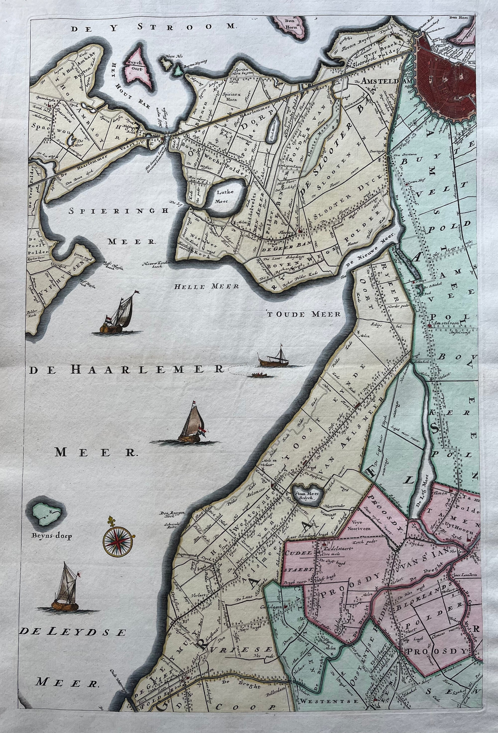
Haarlem region
€600.00
|
/
Quick Shop
Haarlem - Kennemerland
€600.00
|
/
Quick Shop
Leiden
€1,200.00
|
/
Quick Shop
Utrecht Province
€200.00
|
/
Quick Shop
Amsterdam 1482 - 1501
€425.00
|
/
Quick Shop
Amsterdam in 1220
Sold Out
|
/
Quick Shop
Middlesex London Westminster
€950.00
|
/
Quick Shop
Amsterdam in the year 1612
€400.00
|
/
Quick Shop
Amsterdam in 1612
Sold Out
|
/
Quick Shop
Amsterdam in 1585
Sold Out
|
/
Quick Shop
Amsterdam in 1482
Sold Out
|
/
Quick Shop
Overijssel
€450.00
|
/
Quick Shop
North America
€400.00
|
/
Quick Shop
Amsterdam
Sold Out
|
/
Quick Shop
Texel
Sold Out
|
/
Quick Shop
Amsterdam in 1544
€425.00
|
/
Quick Shop
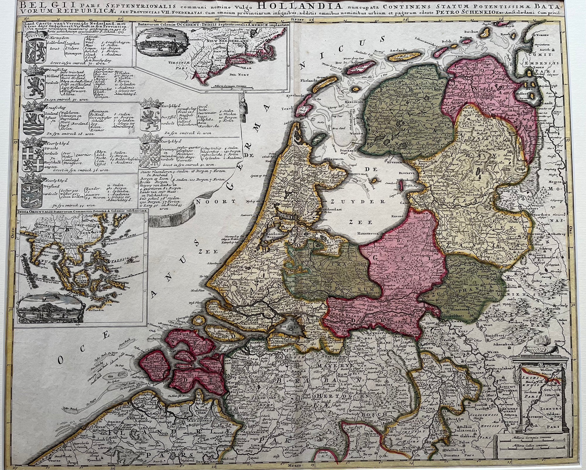
Holland 1680
€750.00
|
/
Quick Shop
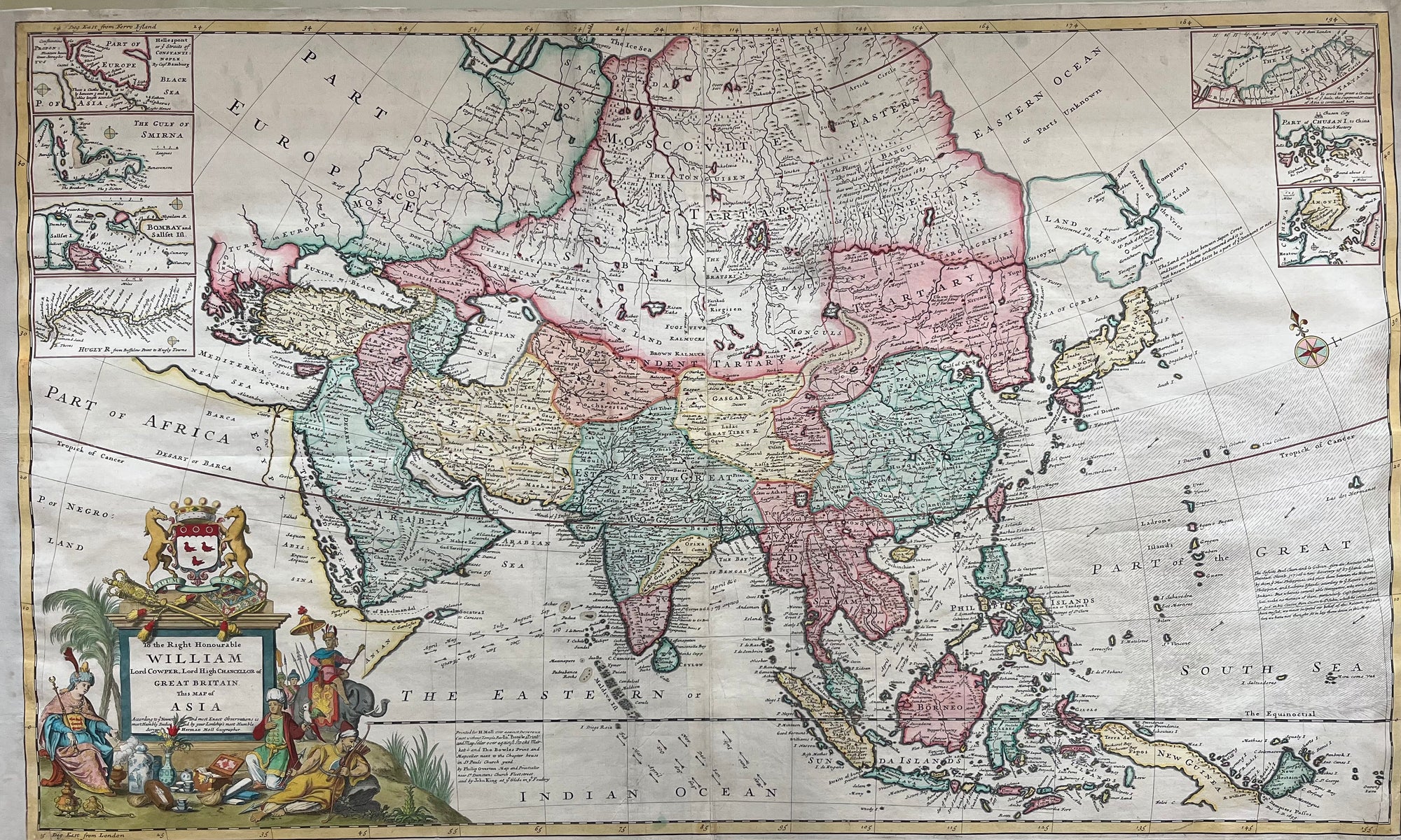
Asia
€2,750.00
|
/
Quick Shop
Friesland
€165.00
|
/
Quick Shop
Republiek der Verenigde Nederlanden
Sold Out
|
/
Quick Shop
Friesland
€450.00
|
/
Quick Shop
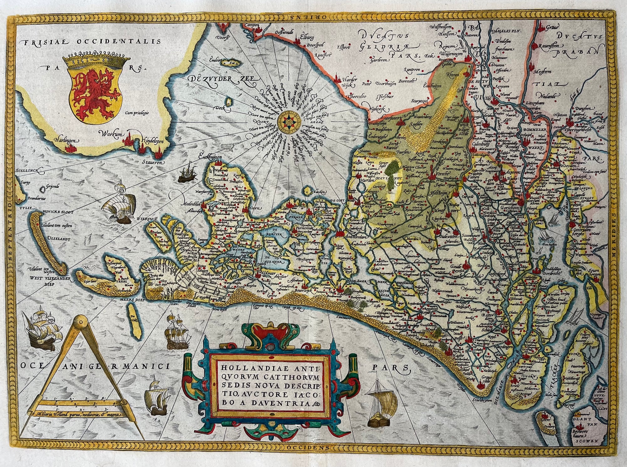
Holland - Ortelius 1570
Sold Out
|
/
Quick Shop
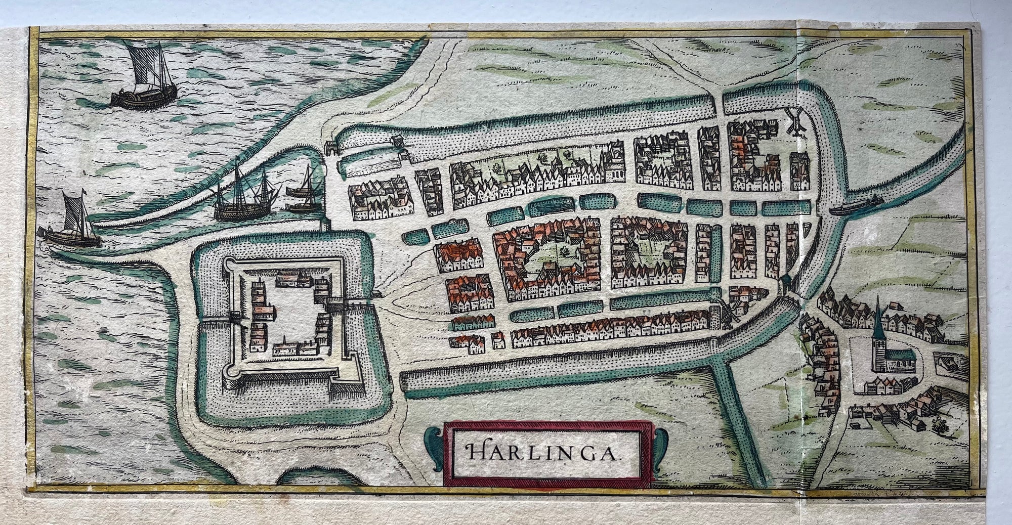
Harlingen
€80.00
|
/
Quick Shop
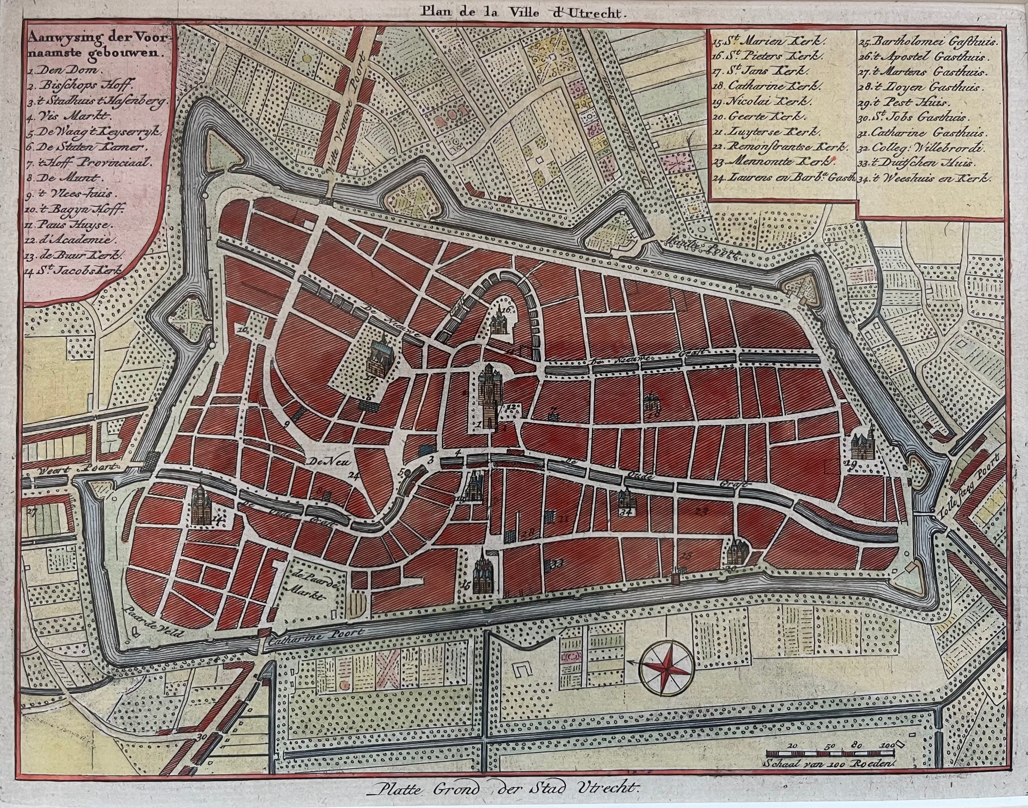
Utrecht
Sold Out
|
/
Quick Shop
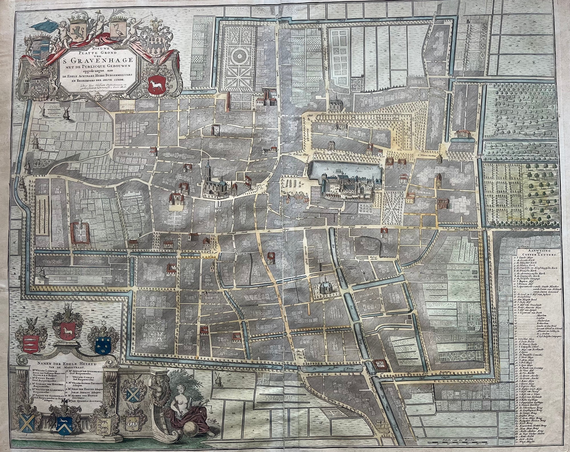
Den Haag
Sold Out
|
/
Quick Shop
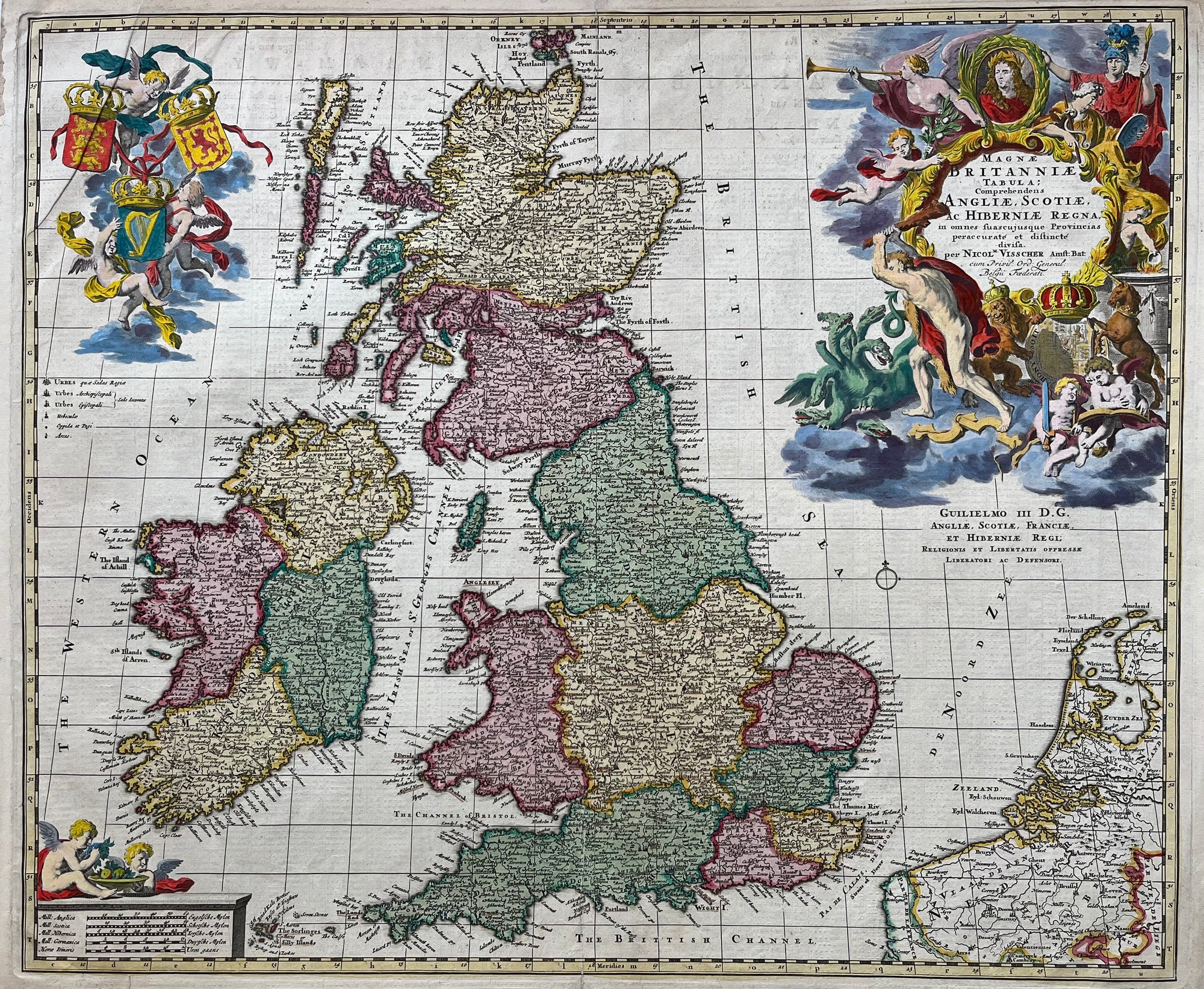
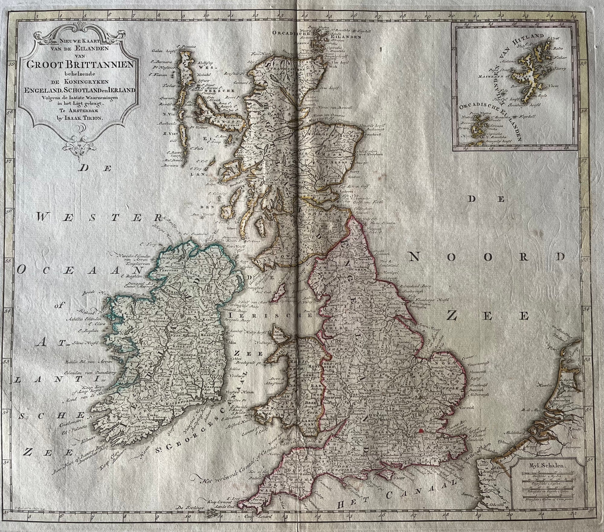
United Kingdom
€500.00
|
/
Quick Shop
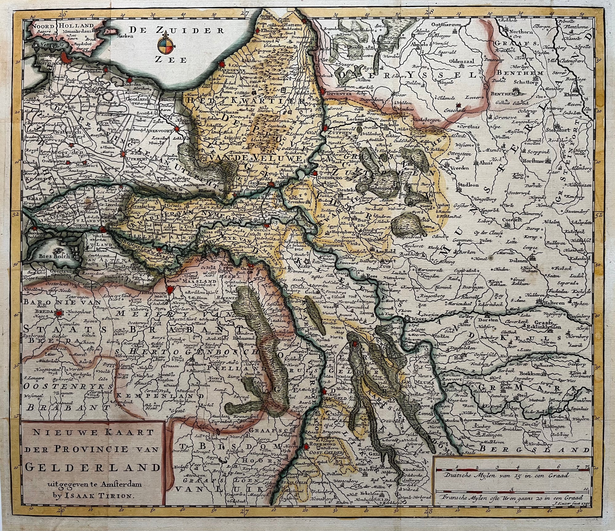
Gelderland
Sold Out
|
/
Quick Shop
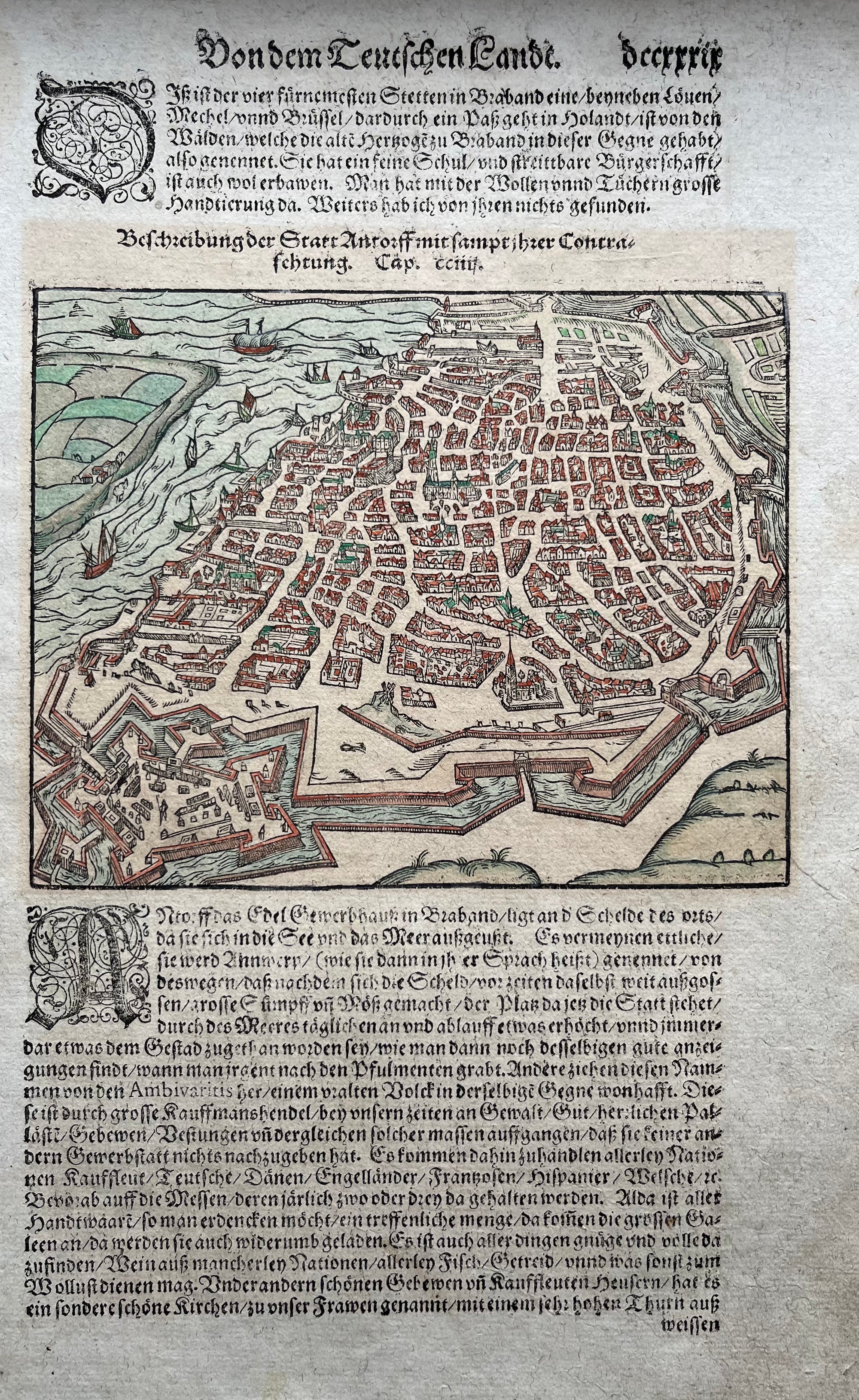
Antwerpen
€125.00
|
/
Quick Shop
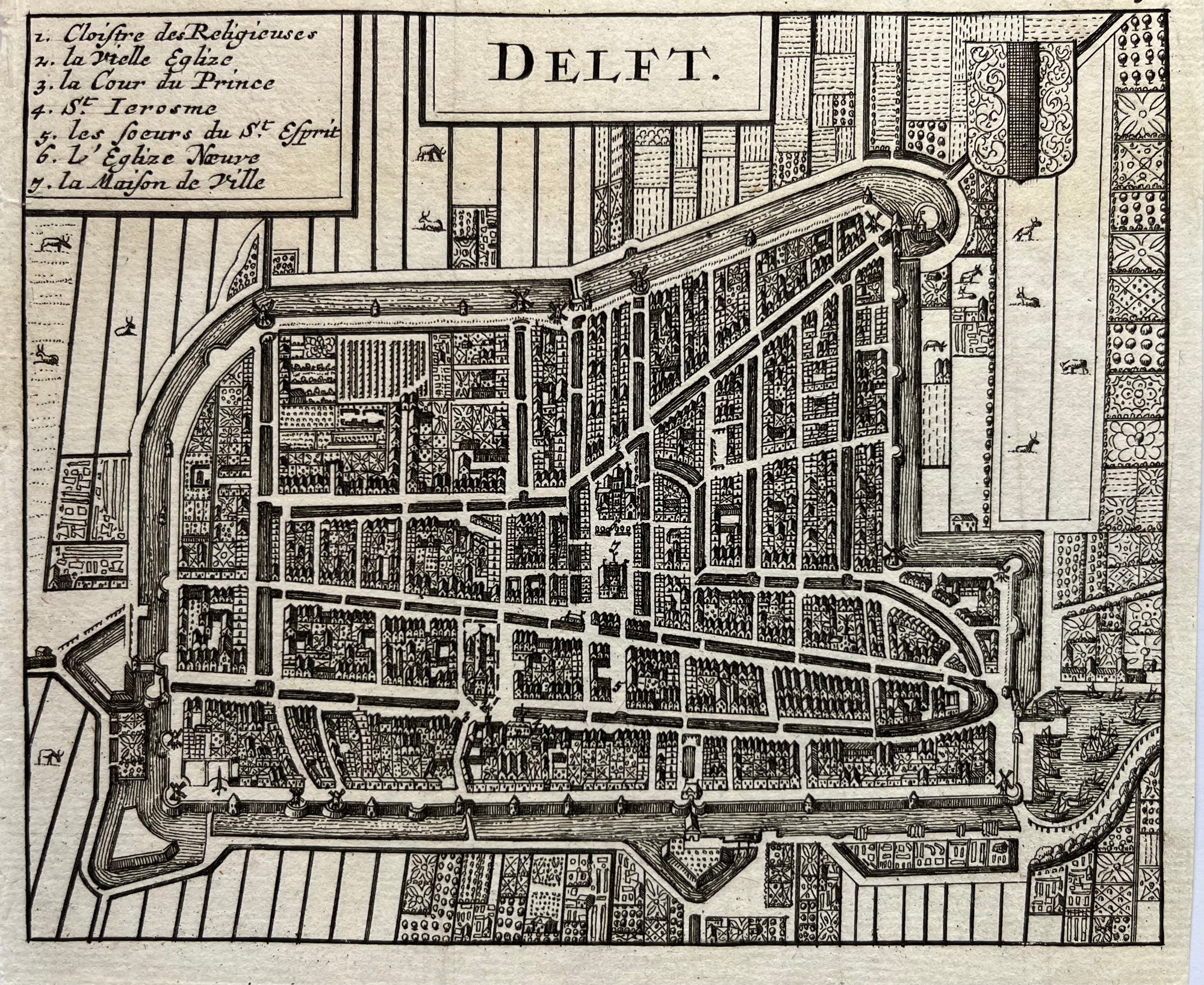
Delft
Sold Out
|
/
Quick Shop
Leiden
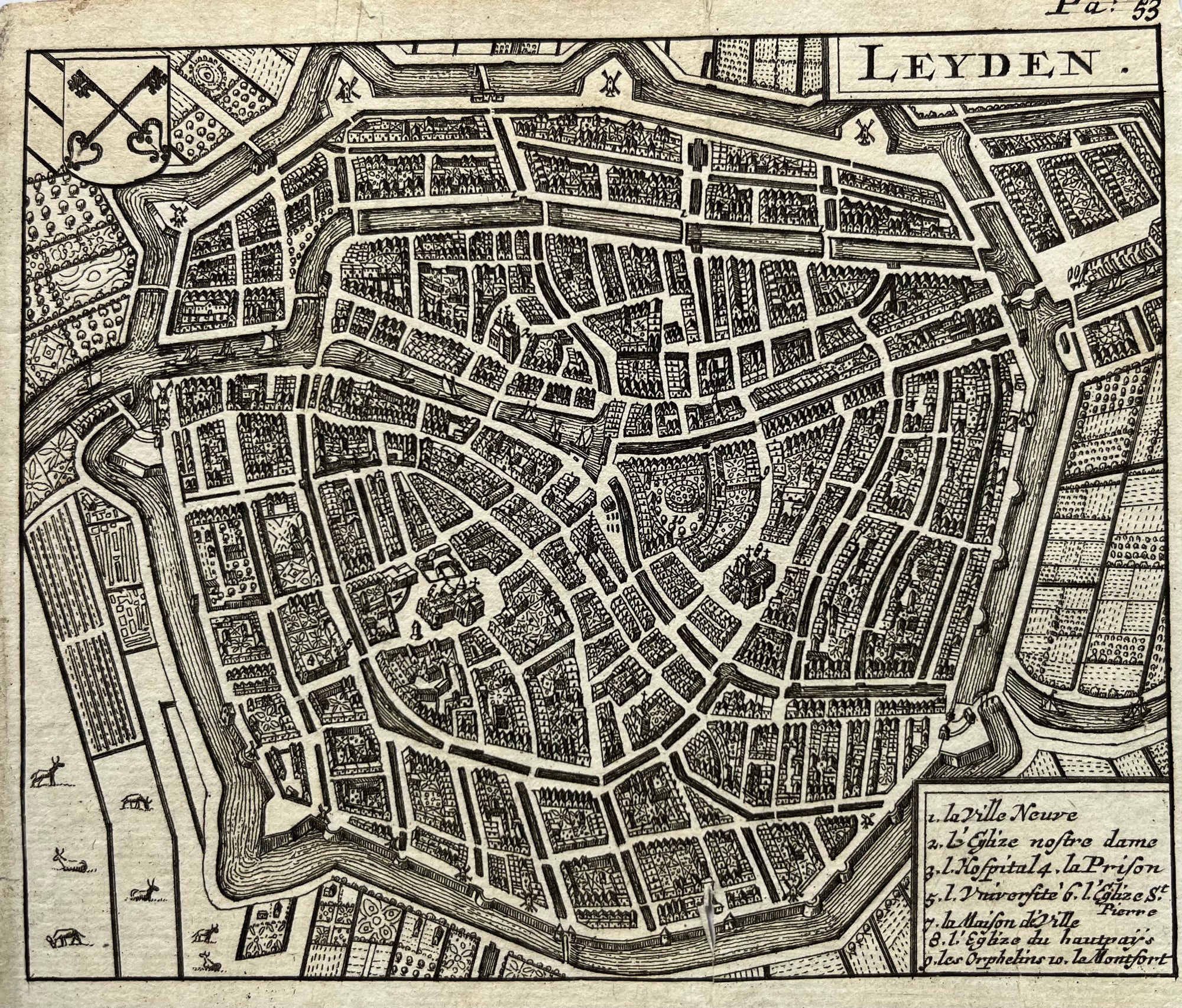
€125.00
|
/
Quick Shop
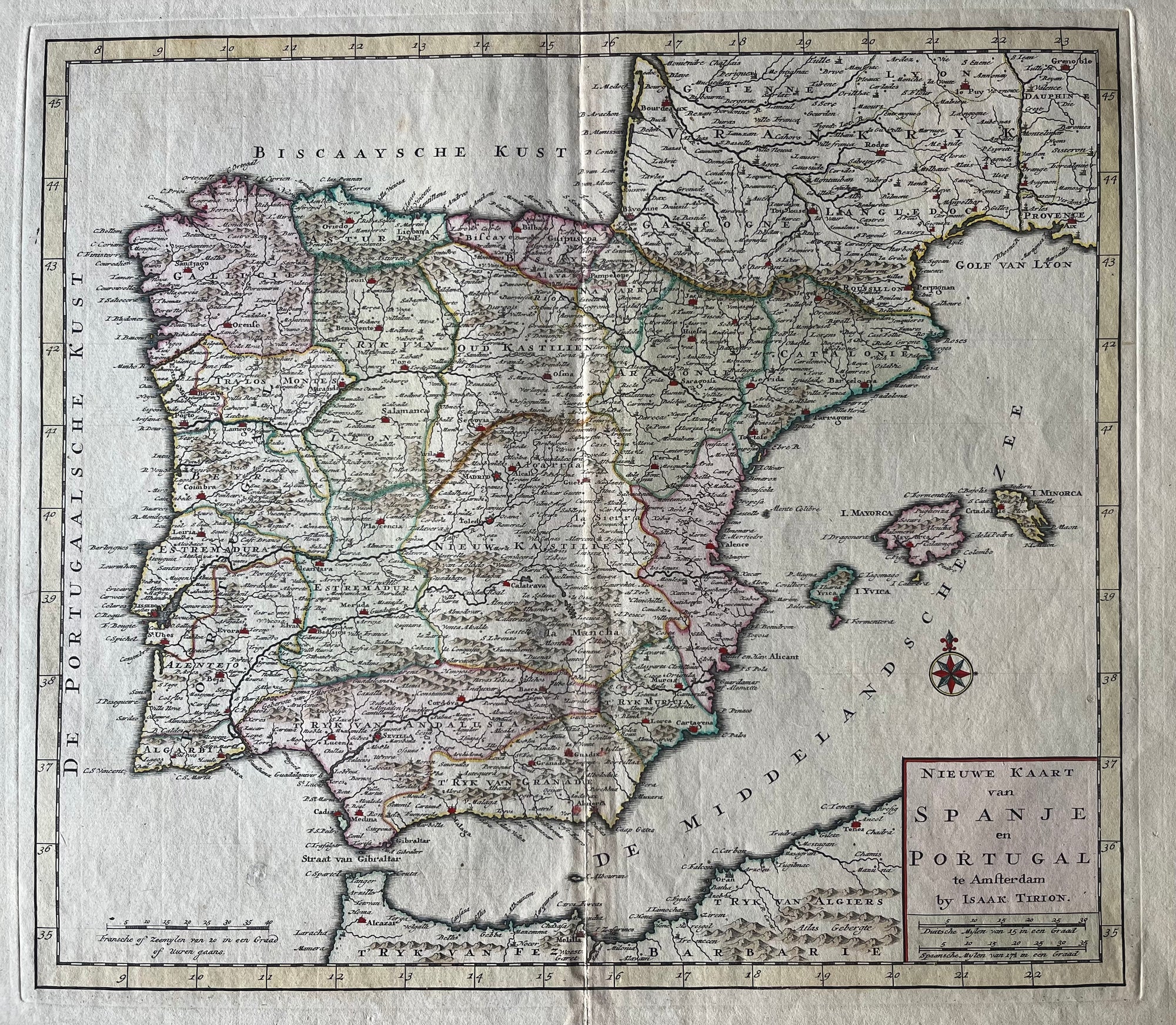
Spain Portugal
€250.00
|
/
Quick Shop
United Kingdom
€200.00
|
/
Quick Shop
Amsterdam area
€450.00
|
/
Quick Shop
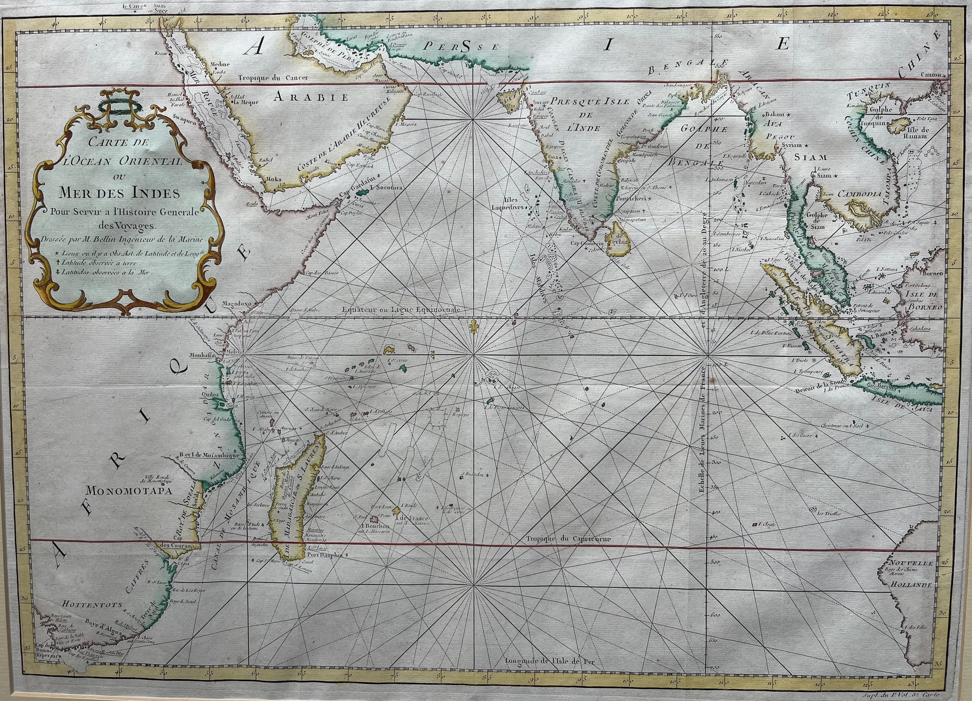
Indian Ocean
€375.00
|
/
Quick Shop
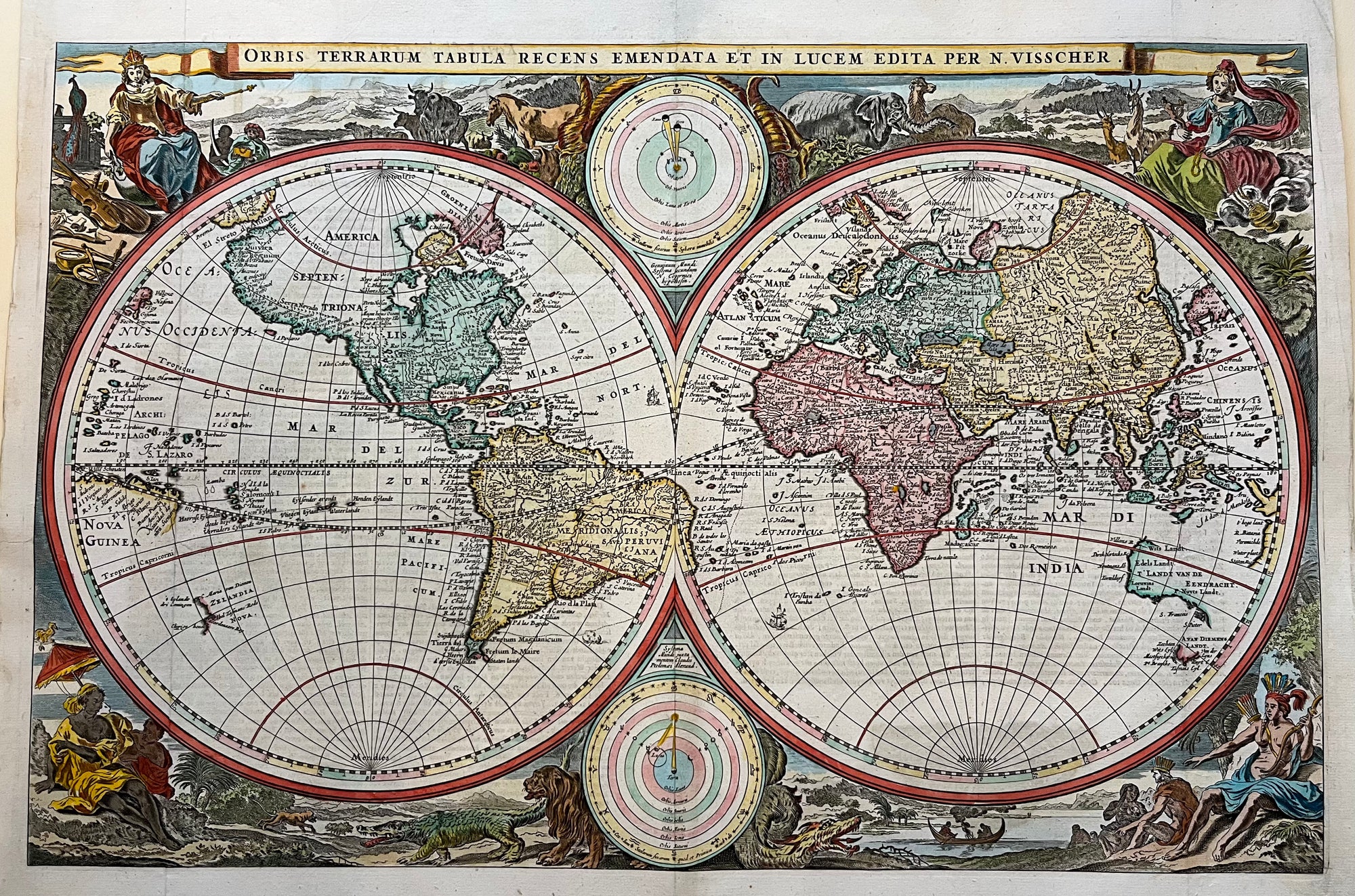
Worldmap by Visscher 1664
Sold Out
|
/
Quick Shop
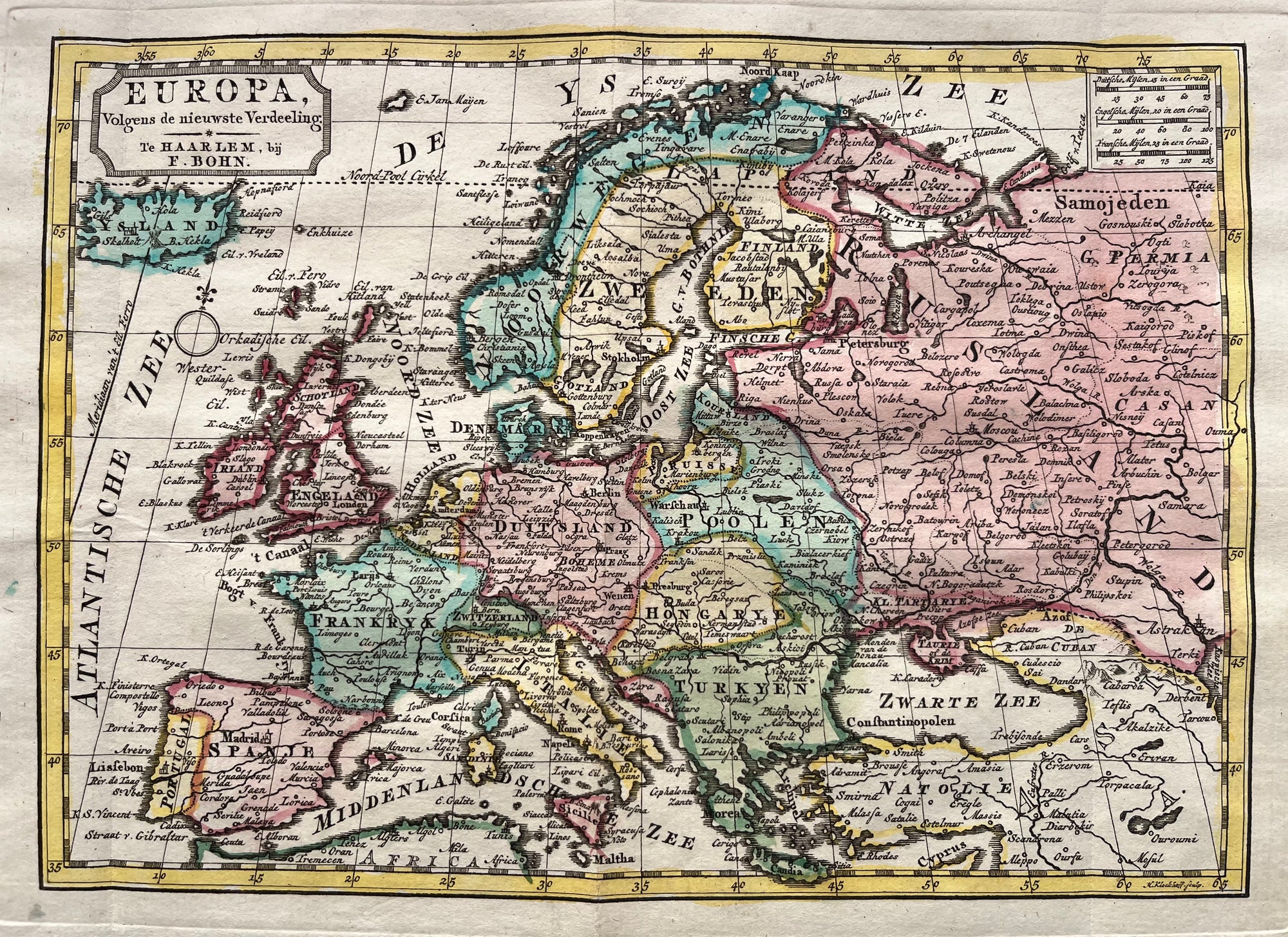
Europe
€150.00
|
/
1
2
3
4
Next