English
Language
English
Nederlands
Submit
Language
English
English
Nederlands
Netherlands (EUR €)
Country
Afghanistan (AF ؋)
Åland Islands (AX €)
Albania (AL L)
Algeria (DZ د.ج)
Andorra (AD €)
Angola (AO €)
Anguilla (AI $)
Antigua & Barbuda (AG $)
Argentina (AR €)
Armenia (AM դր.)
Aruba (AW ƒ)
Ascension Island (AC £)
Australia (AU $)
Austria (AT €)
Azerbaijan (AZ ₼)
Bahamas (BS $)
Bahrain (BH €)
Bangladesh (BD ৳)
Barbados (BB $)
Belarus (BY €)
Belgium (BE €)
Belize (BZ $)
Benin (BJ Fr)
Bermuda (BM $)
Bhutan (BT €)
Bolivia (BO Bs.)
Bosnia & Herzegovina (BA КМ)
Botswana (BW P)
Brazil (BR €)
British Indian Ocean Territory (IO $)
British Virgin Islands (VG $)
Brunei (BN $)
Bulgaria (BG €)
Burkina Faso (BF Fr)
Burundi (BI Fr)
Cambodia (KH ៛)
Cameroon (CM CFA)
Canada (CA $)
Cape Verde (CV $)
Caribbean Netherlands (BQ $)
Cayman Islands (KY $)
Central African Republic (CF CFA)
Chad (TD CFA)
Chile (CL €)
China (CN ¥)
Christmas Island (CX $)
Cocos (Keeling) Islands (CC $)
Colombia (CO €)
Comoros (KM Fr)
Congo - Brazzaville (CG CFA)
Congo - Kinshasa (CD Fr)
Cook Islands (CK $)
Costa Rica (CR ₡)
Côte d’Ivoire (CI Fr)
Croatia (HR €)
Curaçao (CW ƒ)
Cyprus (CY €)
Czechia (CZ Kč)
Denmark (DK kr.)
Djibouti (DJ Fdj)
Dominica (DM $)
Dominican Republic (DO $)
Ecuador (EC $)
Egypt (EG ج.م)
El Salvador (SV $)
Equatorial Guinea (GQ CFA)
Eritrea (ER €)
Estonia (EE €)
Eswatini (SZ €)
Ethiopia (ET Br)
Falkland Islands (FK £)
Faroe Islands (FO kr.)
Fiji (FJ $)
Finland (FI €)
France (FR €)
French Guiana (GF €)
French Polynesia (PF Fr)
French Southern Territories (TF €)
Gabon (GA Fr)
Gambia (GM D)
Georgia (GE €)
Germany (DE €)
Ghana (GH €)
Gibraltar (GI £)
Greece (GR €)
Greenland (GL kr.)
Grenada (GD $)
Guadeloupe (GP €)
Guatemala (GT Q)
Guernsey (GG £)
Guinea (GN Fr)
Guinea-Bissau (GW Fr)
Guyana (GY $)
Haiti (HT €)
Honduras (HN L)
Hong Kong SAR (HK $)
Hungary (HU Ft)
Iceland (IS kr)
India (IN ₹)
Indonesia (ID Rp)
Iraq (IQ €)
Ireland (IE €)
Isle of Man (IM £)
Israel (IL ₪)
Italy (IT €)
Jamaica (JM $)
Japan (JP ¥)
Jersey (JE €)
Jordan (JO €)
Kazakhstan (KZ ₸)
Kenya (KE KSh)
Kiribati (KI €)
Kosovo (XK €)
Kuwait (KW €)
Kyrgyzstan (KG som)
Laos (LA ₭)
Latvia (LV €)
Lebanon (LB ل.ل)
Lesotho (LS €)
Liberia (LR €)
Libya (LY €)
Liechtenstein (LI CHF)
Lithuania (LT €)
Luxembourg (LU €)
Macao SAR (MO P)
Madagascar (MG €)
Malawi (MW MK)
Malaysia (MY RM)
Maldives (MV MVR)
Mali (ML Fr)
Malta (MT €)
Martinique (MQ €)
Mauritania (MR €)
Mauritius (MU ₨)
Mayotte (YT €)
Mexico (MX €)
Moldova (MD L)
Monaco (MC €)
Mongolia (MN ₮)
Montenegro (ME €)
Montserrat (MS $)
Morocco (MA د.م.)
Mozambique (MZ €)
Myanmar (Burma) (MM K)
Namibia (NA €)
Nauru (NR $)
Nepal (NP Rs.)
Netherlands (NL €)
New Caledonia (NC Fr)
New Zealand (NZ $)
Nicaragua (NI C$)
Niger (NE Fr)
Nigeria (NG ₦)
Niue (NU $)
Norfolk Island (NF $)
North Macedonia (MK ден)
Norway (NO €)
Oman (OM €)
Pakistan (PK ₨)
Palestinian Territories (PS ₪)
Panama (PA $)
Papua New Guinea (PG K)
Paraguay (PY ₲)
Peru (PE S/)
Philippines (PH ₱)
Pitcairn Islands (PN $)
Poland (PL zł)
Portugal (PT €)
Qatar (QA ر.ق)
Réunion (RE €)
Romania (RO Lei)
Russia (RU €)
Rwanda (RW FRw)
Samoa (WS T)
San Marino (SM €)
São Tomé & Príncipe (ST Db)
Saudi Arabia (SA ر.س)
Senegal (SN Fr)
Serbia (RS РСД)
Seychelles (SC €)
Sierra Leone (SL Le)
Singapore (SG $)
Sint Maarten (SX ƒ)
Slovakia (SK €)
Slovenia (SI €)
Solomon Islands (SB $)
Somalia (SO €)
South Africa (ZA €)
South Georgia & South Sandwich Islands (GS £)
South Korea (KR ₩)
South Sudan (SS €)
Spain (ES €)
Sri Lanka (LK ₨)
St. Barthélemy (BL €)
St. Helena (SH £)
St. Kitts & Nevis (KN $)
St. Lucia (LC $)
St. Martin (MF €)
St. Pierre & Miquelon (PM €)
St. Vincent & Grenadines (VC $)
Sudan (SD €)
Suriname (SR €)
Svalbard & Jan Mayen (SJ €)
Sweden (SE kr)
Switzerland (CH CHF)
Taiwan (TW $)
Tajikistan (TJ ЅМ)
Tanzania (TZ Sh)
Thailand (TH ฿)
Timor-Leste (TL $)
Togo (TG Fr)
Tokelau (TK $)
Tonga (TO T$)
Trinidad & Tobago (TT $)
Tristan da Cunha (TA £)
Tunisia (TN €)
Türkiye (TR €)
Turkmenistan (TM €)
Turks & Caicos Islands (TC $)
Tuvalu (TV $)
U.S. Outlying Islands (UM $)
Uganda (UG USh)
Ukraine (UA ₴)
United Arab Emirates (AE د.إ)
United Kingdom (GB £)
United States (US $)
Uruguay (UY $U)
Uzbekistan (UZ so'm)
Vanuatu (VU Vt)
Vatican City (VA €)
Venezuela (VE $)
Vietnam (VN ₫)
Wallis & Futuna (WF Fr)
Western Sahara (EH د.م.)
Yemen (YE ﷼)
Zambia (ZM €)
Zimbabwe (ZW $)
Submit
Country
Netherlands (EUR €)
Afghanistan (AFN ؋)
Åland Islands (EUR €)
Albania (ALL L)
Algeria (DZD د.ج)
Andorra (EUR €)
Angola (EUR €)
Anguilla (XCD $)
Antigua & Barbuda (XCD $)
Argentina (EUR €)
Armenia (AMD դր.)
Aruba (AWG ƒ)
Ascension Island (SHP £)
Australia (AUD $)
Austria (EUR €)
Azerbaijan (AZN ₼)
Bahamas (BSD $)
Bahrain (EUR €)
Bangladesh (BDT ৳)
Barbados (BBD $)
Belarus (EUR €)
Belgium (EUR €)
Belize (BZD $)
Benin (XOF Fr)
Bermuda (USD $)
Bhutan (EUR €)
Bolivia (BOB Bs.)
Bosnia & Herzegovina (BAM КМ)
Botswana (BWP P)
Brazil (EUR €)
British Indian Ocean Territory (USD $)
British Virgin Islands (USD $)
Brunei (BND $)
Bulgaria (EUR €)
Burkina Faso (XOF Fr)
Burundi (BIF Fr)
Cambodia (KHR ៛)
Cameroon (XAF CFA)
Canada (CAD $)
Cape Verde (CVE $)
Caribbean Netherlands (USD $)
Cayman Islands (KYD $)
Central African Republic (XAF CFA)
Chad (XAF CFA)
Chile (EUR €)
China (CNY ¥)
Christmas Island (AUD $)
Cocos (Keeling) Islands (AUD $)
Colombia (EUR €)
Comoros (KMF Fr)
Congo - Brazzaville (XAF CFA)
Congo - Kinshasa (CDF Fr)
Cook Islands (NZD $)
Costa Rica (CRC ₡)
Côte d’Ivoire (XOF Fr)
Croatia (EUR €)
Curaçao (ANG ƒ)
Cyprus (EUR €)
Czechia (CZK Kč)
Denmark (DKK kr.)
Djibouti (DJF Fdj)
Dominica (XCD $)
Dominican Republic (DOP $)
Ecuador (USD $)
Egypt (EGP ج.م)
El Salvador (USD $)
Equatorial Guinea (XAF CFA)
Eritrea (EUR €)
Estonia (EUR €)
Eswatini (EUR €)
Ethiopia (ETB Br)
Falkland Islands (FKP £)
Faroe Islands (DKK kr.)
Fiji (FJD $)
Finland (EUR €)
France (EUR €)
French Guiana (EUR €)
French Polynesia (XPF Fr)
French Southern Territories (EUR €)
Gabon (XOF Fr)
Gambia (GMD D)
Georgia (EUR €)
Germany (EUR €)
Ghana (EUR €)
Gibraltar (GBP £)
Greece (EUR €)
Greenland (DKK kr.)
Grenada (XCD $)
Guadeloupe (EUR €)
Guatemala (GTQ Q)
Guernsey (GBP £)
Guinea (GNF Fr)
Guinea-Bissau (XOF Fr)
Guyana (GYD $)
Haiti (EUR €)
Honduras (HNL L)
Hong Kong SAR (HKD $)
Hungary (HUF Ft)
Iceland (ISK kr)
India (INR ₹)
Indonesia (IDR Rp)
Iraq (EUR €)
Ireland (EUR €)
Isle of Man (GBP £)
Israel (ILS ₪)
Italy (EUR €)
Jamaica (JMD $)
Japan (JPY ¥)
Jersey (EUR €)
Jordan (EUR €)
Kazakhstan (KZT ₸)
Kenya (KES KSh)
Kiribati (EUR €)
Kosovo (EUR €)
Kuwait (EUR €)
Kyrgyzstan (KGS som)
Laos (LAK ₭)
Latvia (EUR €)
Lebanon (LBP ل.ل)
Lesotho (EUR €)
Liberia (EUR €)
Libya (EUR €)
Liechtenstein (CHF CHF)
Lithuania (EUR €)
Luxembourg (EUR €)
Macao SAR (MOP P)
Madagascar (EUR €)
Malawi (MWK MK)
Malaysia (MYR RM)
Maldives (MVR MVR)
Mali (XOF Fr)
Malta (EUR €)
Martinique (EUR €)
Mauritania (EUR €)
Mauritius (MUR ₨)
Mayotte (EUR €)
Mexico (EUR €)
Moldova (MDL L)
Monaco (EUR €)
Mongolia (MNT ₮)
Montenegro (EUR €)
Montserrat (XCD $)
Morocco (MAD د.م.)
Mozambique (EUR €)
Myanmar (Burma) (MMK K)
Namibia (EUR €)
Nauru (AUD $)
Nepal (NPR Rs.)
Netherlands (EUR €)
New Caledonia (XPF Fr)
New Zealand (NZD $)
Nicaragua (NIO C$)
Niger (XOF Fr)
Nigeria (NGN ₦)
Niue (NZD $)
Norfolk Island (AUD $)
North Macedonia (MKD ден)
Norway (EUR €)
Oman (EUR €)
Pakistan (PKR ₨)
Palestinian Territories (ILS ₪)
Panama (USD $)
Papua New Guinea (PGK K)
Paraguay (PYG ₲)
Peru (PEN S/)
Philippines (PHP ₱)
Pitcairn Islands (NZD $)
Poland (PLN zł)
Portugal (EUR €)
Qatar (QAR ر.ق)
Réunion (EUR €)
Romania (RON Lei)
Russia (EUR €)
Rwanda (RWF FRw)
Samoa (WST T)
San Marino (EUR €)
São Tomé & Príncipe (STD Db)
Saudi Arabia (SAR ر.س)
Senegal (XOF Fr)
Serbia (RSD РСД)
Seychelles (EUR €)
Sierra Leone (SLL Le)
Singapore (SGD $)
Sint Maarten (ANG ƒ)
Slovakia (EUR €)
Slovenia (EUR €)
Solomon Islands (SBD $)
Somalia (EUR €)
South Africa (EUR €)
South Georgia & South Sandwich Islands (GBP £)
South Korea (KRW ₩)
South Sudan (EUR €)
Spain (EUR €)
Sri Lanka (LKR ₨)
St. Barthélemy (EUR €)
St. Helena (SHP £)
St. Kitts & Nevis (XCD $)
St. Lucia (XCD $)
St. Martin (EUR €)
St. Pierre & Miquelon (EUR €)
St. Vincent & Grenadines (XCD $)
Sudan (EUR €)
Suriname (EUR €)
Svalbard & Jan Mayen (EUR €)
Sweden (SEK kr)
Switzerland (CHF CHF)
Taiwan (TWD $)
Tajikistan (TJS ЅМ)
Tanzania (TZS Sh)
Thailand (THB ฿)
Timor-Leste (USD $)
Togo (XOF Fr)
Tokelau (NZD $)
Tonga (TOP T$)
Trinidad & Tobago (TTD $)
Tristan da Cunha (GBP £)
Tunisia (EUR €)
Türkiye (EUR €)
Turkmenistan (EUR €)
Turks & Caicos Islands (USD $)
Tuvalu (AUD $)
U.S. Outlying Islands (USD $)
Uganda (UGX USh)
Ukraine (UAH ₴)
United Arab Emirates (AED د.إ)
United Kingdom (GBP £)
United States (USD $)
Uruguay (UYU $U)
Uzbekistan (UZS so'm)
Vanuatu (VUV Vt)
Vatican City (EUR €)
Venezuela (USD $)
Vietnam (VND ₫)
Wallis & Futuna (XPF Fr)
Western Sahara (MAD د.م.)
Yemen (YER ﷼)
Zambia (EUR €)
Zimbabwe (USD $)
+ 31 6 15 82 10 92
Log in
Cart (
0
)
Checkout
Antiquariaat De Vries & De Vries
Maps & townplans
Dutch
Groningen
Friesland
Drenthe
Overijssel
Gelderland
Utrecht
Noord-Holland
Zuid-Holland
Zeeland
Brabant
Limburg
Europe
Belgium
France
Germany
Italy
Spain
United Kingdom
Rest of Europe
Rest of the world
Africa
America
Asia
Australia
Latin America
City views
Haarlem
Amsterdam
Rotterdam
Den Haag
Dutch
Groningen
Friesland
Drenthe
Overijssel
Gelderland
Utrecht
Noord-Holland
Zuid-Holland
Zeeland
Brabant
Limburg
Europe
Rest of the world
Miscellaneous
Botanical Prints
Bird Prints
Maritime Prints
Varia
Winter Scenes
About us
Contact
Framing & Delivery
FAQ
English
Language
English
Nederlands
Submit
Language
English
English
Nederlands
Netherlands (EUR €)
Country
Afghanistan (AF ؋)
Åland Islands (AX €)
Albania (AL L)
Algeria (DZ د.ج)
Andorra (AD €)
Angola (AO €)
Anguilla (AI $)
Antigua & Barbuda (AG $)
Argentina (AR €)
Armenia (AM դր.)
Aruba (AW ƒ)
Ascension Island (AC £)
Australia (AU $)
Austria (AT €)
Azerbaijan (AZ ₼)
Bahamas (BS $)
Bahrain (BH €)
Bangladesh (BD ৳)
Barbados (BB $)
Belarus (BY €)
Belgium (BE €)
Belize (BZ $)
Benin (BJ Fr)
Bermuda (BM $)
Bhutan (BT €)
Bolivia (BO Bs.)
Bosnia & Herzegovina (BA КМ)
Botswana (BW P)
Brazil (BR €)
British Indian Ocean Territory (IO $)
British Virgin Islands (VG $)
Brunei (BN $)
Bulgaria (BG €)
Burkina Faso (BF Fr)
Burundi (BI Fr)
Cambodia (KH ៛)
Cameroon (CM CFA)
Canada (CA $)
Cape Verde (CV $)
Caribbean Netherlands (BQ $)
Cayman Islands (KY $)
Central African Republic (CF CFA)
Chad (TD CFA)
Chile (CL €)
China (CN ¥)
Christmas Island (CX $)
Cocos (Keeling) Islands (CC $)
Colombia (CO €)
Comoros (KM Fr)
Congo - Brazzaville (CG CFA)
Congo - Kinshasa (CD Fr)
Cook Islands (CK $)
Costa Rica (CR ₡)
Côte d’Ivoire (CI Fr)
Croatia (HR €)
Curaçao (CW ƒ)
Cyprus (CY €)
Czechia (CZ Kč)
Denmark (DK kr.)
Djibouti (DJ Fdj)
Dominica (DM $)
Dominican Republic (DO $)
Ecuador (EC $)
Egypt (EG ج.م)
El Salvador (SV $)
Equatorial Guinea (GQ CFA)
Eritrea (ER €)
Estonia (EE €)
Eswatini (SZ €)
Ethiopia (ET Br)
Falkland Islands (FK £)
Faroe Islands (FO kr.)
Fiji (FJ $)
Finland (FI €)
France (FR €)
French Guiana (GF €)
French Polynesia (PF Fr)
French Southern Territories (TF €)
Gabon (GA Fr)
Gambia (GM D)
Georgia (GE €)
Germany (DE €)
Ghana (GH €)
Gibraltar (GI £)
Greece (GR €)
Greenland (GL kr.)
Grenada (GD $)
Guadeloupe (GP €)
Guatemala (GT Q)
Guernsey (GG £)
Guinea (GN Fr)
Guinea-Bissau (GW Fr)
Guyana (GY $)
Haiti (HT €)
Honduras (HN L)
Hong Kong SAR (HK $)
Hungary (HU Ft)
Iceland (IS kr)
India (IN ₹)
Indonesia (ID Rp)
Iraq (IQ €)
Ireland (IE €)
Isle of Man (IM £)
Israel (IL ₪)
Italy (IT €)
Jamaica (JM $)
Japan (JP ¥)
Jersey (JE €)
Jordan (JO €)
Kazakhstan (KZ ₸)
Kenya (KE KSh)
Kiribati (KI €)
Kosovo (XK €)
Kuwait (KW €)
Kyrgyzstan (KG som)
Laos (LA ₭)
Latvia (LV €)
Lebanon (LB ل.ل)
Lesotho (LS €)
Liberia (LR €)
Libya (LY €)
Liechtenstein (LI CHF)
Lithuania (LT €)
Luxembourg (LU €)
Macao SAR (MO P)
Madagascar (MG €)
Malawi (MW MK)
Malaysia (MY RM)
Maldives (MV MVR)
Mali (ML Fr)
Malta (MT €)
Martinique (MQ €)
Mauritania (MR €)
Mauritius (MU ₨)
Mayotte (YT €)
Mexico (MX €)
Moldova (MD L)
Monaco (MC €)
Mongolia (MN ₮)
Montenegro (ME €)
Montserrat (MS $)
Morocco (MA د.م.)
Mozambique (MZ €)
Myanmar (Burma) (MM K)
Namibia (NA €)
Nauru (NR $)
Nepal (NP Rs.)
Netherlands (NL €)
New Caledonia (NC Fr)
New Zealand (NZ $)
Nicaragua (NI C$)
Niger (NE Fr)
Nigeria (NG ₦)
Niue (NU $)
Norfolk Island (NF $)
North Macedonia (MK ден)
Norway (NO €)
Oman (OM €)
Pakistan (PK ₨)
Palestinian Territories (PS ₪)
Panama (PA $)
Papua New Guinea (PG K)
Paraguay (PY ₲)
Peru (PE S/)
Philippines (PH ₱)
Pitcairn Islands (PN $)
Poland (PL zł)
Portugal (PT €)
Qatar (QA ر.ق)
Réunion (RE €)
Romania (RO Lei)
Russia (RU €)
Rwanda (RW FRw)
Samoa (WS T)
San Marino (SM €)
São Tomé & Príncipe (ST Db)
Saudi Arabia (SA ر.س)
Senegal (SN Fr)
Serbia (RS РСД)
Seychelles (SC €)
Sierra Leone (SL Le)
Singapore (SG $)
Sint Maarten (SX ƒ)
Slovakia (SK €)
Slovenia (SI €)
Solomon Islands (SB $)
Somalia (SO €)
South Africa (ZA €)
South Georgia & South Sandwich Islands (GS £)
South Korea (KR ₩)
South Sudan (SS €)
Spain (ES €)
Sri Lanka (LK ₨)
St. Barthélemy (BL €)
St. Helena (SH £)
St. Kitts & Nevis (KN $)
St. Lucia (LC $)
St. Martin (MF €)
St. Pierre & Miquelon (PM €)
St. Vincent & Grenadines (VC $)
Sudan (SD €)
Suriname (SR €)
Svalbard & Jan Mayen (SJ €)
Sweden (SE kr)
Switzerland (CH CHF)
Taiwan (TW $)
Tajikistan (TJ ЅМ)
Tanzania (TZ Sh)
Thailand (TH ฿)
Timor-Leste (TL $)
Togo (TG Fr)
Tokelau (TK $)
Tonga (TO T$)
Trinidad & Tobago (TT $)
Tristan da Cunha (TA £)
Tunisia (TN €)
Türkiye (TR €)
Turkmenistan (TM €)
Turks & Caicos Islands (TC $)
Tuvalu (TV $)
U.S. Outlying Islands (UM $)
Uganda (UG USh)
Ukraine (UA ₴)
United Arab Emirates (AE د.إ)
United Kingdom (GB £)
United States (US $)
Uruguay (UY $U)
Uzbekistan (UZ so'm)
Vanuatu (VU Vt)
Vatican City (VA €)
Venezuela (VE $)
Vietnam (VN ₫)
Wallis & Futuna (WF Fr)
Western Sahara (EH د.م.)
Yemen (YE ﷼)
Zambia (ZM €)
Zimbabwe (ZW $)
Submit
Country
Netherlands (EUR €)
Afghanistan (AFN ؋)
Åland Islands (EUR €)
Albania (ALL L)
Algeria (DZD د.ج)
Andorra (EUR €)
Angola (EUR €)
Anguilla (XCD $)
Antigua & Barbuda (XCD $)
Argentina (EUR €)
Armenia (AMD դր.)
Aruba (AWG ƒ)
Ascension Island (SHP £)
Australia (AUD $)
Austria (EUR €)
Azerbaijan (AZN ₼)
Bahamas (BSD $)
Bahrain (EUR €)
Bangladesh (BDT ৳)
Barbados (BBD $)
Belarus (EUR €)
Belgium (EUR €)
Belize (BZD $)
Benin (XOF Fr)
Bermuda (USD $)
Bhutan (EUR €)
Bolivia (BOB Bs.)
Bosnia & Herzegovina (BAM КМ)
Botswana (BWP P)
Brazil (EUR €)
British Indian Ocean Territory (USD $)
British Virgin Islands (USD $)
Brunei (BND $)
Bulgaria (EUR €)
Burkina Faso (XOF Fr)
Burundi (BIF Fr)
Cambodia (KHR ៛)
Cameroon (XAF CFA)
Canada (CAD $)
Cape Verde (CVE $)
Caribbean Netherlands (USD $)
Cayman Islands (KYD $)
Central African Republic (XAF CFA)
Chad (XAF CFA)
Chile (EUR €)
China (CNY ¥)
Christmas Island (AUD $)
Cocos (Keeling) Islands (AUD $)
Colombia (EUR €)
Comoros (KMF Fr)
Congo - Brazzaville (XAF CFA)
Congo - Kinshasa (CDF Fr)
Cook Islands (NZD $)
Costa Rica (CRC ₡)
Côte d’Ivoire (XOF Fr)
Croatia (EUR €)
Curaçao (ANG ƒ)
Cyprus (EUR €)
Czechia (CZK Kč)
Denmark (DKK kr.)
Djibouti (DJF Fdj)
Dominica (XCD $)
Dominican Republic (DOP $)
Ecuador (USD $)
Egypt (EGP ج.م)
El Salvador (USD $)
Equatorial Guinea (XAF CFA)
Eritrea (EUR €)
Estonia (EUR €)
Eswatini (EUR €)
Ethiopia (ETB Br)
Falkland Islands (FKP £)
Faroe Islands (DKK kr.)
Fiji (FJD $)
Finland (EUR €)
France (EUR €)
French Guiana (EUR €)
French Polynesia (XPF Fr)
French Southern Territories (EUR €)
Gabon (XOF Fr)
Gambia (GMD D)
Georgia (EUR €)
Germany (EUR €)
Ghana (EUR €)
Gibraltar (GBP £)
Greece (EUR €)
Greenland (DKK kr.)
Grenada (XCD $)
Guadeloupe (EUR €)
Guatemala (GTQ Q)
Guernsey (GBP £)
Guinea (GNF Fr)
Guinea-Bissau (XOF Fr)
Guyana (GYD $)
Haiti (EUR €)
Honduras (HNL L)
Hong Kong SAR (HKD $)
Hungary (HUF Ft)
Iceland (ISK kr)
India (INR ₹)
Indonesia (IDR Rp)
Iraq (EUR €)
Ireland (EUR €)
Isle of Man (GBP £)
Israel (ILS ₪)
Italy (EUR €)
Jamaica (JMD $)
Japan (JPY ¥)
Jersey (EUR €)
Jordan (EUR €)
Kazakhstan (KZT ₸)
Kenya (KES KSh)
Kiribati (EUR €)
Kosovo (EUR €)
Kuwait (EUR €)
Kyrgyzstan (KGS som)
Laos (LAK ₭)
Latvia (EUR €)
Lebanon (LBP ل.ل)
Lesotho (EUR €)
Liberia (EUR €)
Libya (EUR €)
Liechtenstein (CHF CHF)
Lithuania (EUR €)
Luxembourg (EUR €)
Macao SAR (MOP P)
Madagascar (EUR €)
Malawi (MWK MK)
Malaysia (MYR RM)
Maldives (MVR MVR)
Mali (XOF Fr)
Malta (EUR €)
Martinique (EUR €)
Mauritania (EUR €)
Mauritius (MUR ₨)
Mayotte (EUR €)
Mexico (EUR €)
Moldova (MDL L)
Monaco (EUR €)
Mongolia (MNT ₮)
Montenegro (EUR €)
Montserrat (XCD $)
Morocco (MAD د.م.)
Mozambique (EUR €)
Myanmar (Burma) (MMK K)
Namibia (EUR €)
Nauru (AUD $)
Nepal (NPR Rs.)
Netherlands (EUR €)
New Caledonia (XPF Fr)
New Zealand (NZD $)
Nicaragua (NIO C$)
Niger (XOF Fr)
Nigeria (NGN ₦)
Niue (NZD $)
Norfolk Island (AUD $)
North Macedonia (MKD ден)
Norway (EUR €)
Oman (EUR €)
Pakistan (PKR ₨)
Palestinian Territories (ILS ₪)
Panama (USD $)
Papua New Guinea (PGK K)
Paraguay (PYG ₲)
Peru (PEN S/)
Philippines (PHP ₱)
Pitcairn Islands (NZD $)
Poland (PLN zł)
Portugal (EUR €)
Qatar (QAR ر.ق)
Réunion (EUR €)
Romania (RON Lei)
Russia (EUR €)
Rwanda (RWF FRw)
Samoa (WST T)
San Marino (EUR €)
São Tomé & Príncipe (STD Db)
Saudi Arabia (SAR ر.س)
Senegal (XOF Fr)
Serbia (RSD РСД)
Seychelles (EUR €)
Sierra Leone (SLL Le)
Singapore (SGD $)
Sint Maarten (ANG ƒ)
Slovakia (EUR €)
Slovenia (EUR €)
Solomon Islands (SBD $)
Somalia (EUR €)
South Africa (EUR €)
South Georgia & South Sandwich Islands (GBP £)
South Korea (KRW ₩)
South Sudan (EUR €)
Spain (EUR €)
Sri Lanka (LKR ₨)
St. Barthélemy (EUR €)
St. Helena (SHP £)
St. Kitts & Nevis (XCD $)
St. Lucia (XCD $)
St. Martin (EUR €)
St. Pierre & Miquelon (EUR €)
St. Vincent & Grenadines (XCD $)
Sudan (EUR €)
Suriname (EUR €)
Svalbard & Jan Mayen (EUR €)
Sweden (SEK kr)
Switzerland (CHF CHF)
Taiwan (TWD $)
Tajikistan (TJS ЅМ)
Tanzania (TZS Sh)
Thailand (THB ฿)
Timor-Leste (USD $)
Togo (XOF Fr)
Tokelau (NZD $)
Tonga (TOP T$)
Trinidad & Tobago (TTD $)
Tristan da Cunha (GBP £)
Tunisia (EUR €)
Türkiye (EUR €)
Turkmenistan (EUR €)
Turks & Caicos Islands (USD $)
Tuvalu (AUD $)
U.S. Outlying Islands (USD $)
Uganda (UGX USh)
Ukraine (UAH ₴)
United Arab Emirates (AED د.إ)
United Kingdom (GBP £)
United States (USD $)
Uruguay (UYU $U)
Uzbekistan (UZS so'm)
Vanuatu (VUV Vt)
Vatican City (EUR €)
Venezuela (USD $)
Vietnam (VND ₫)
Wallis & Futuna (XPF Fr)
Western Sahara (MAD د.م.)
Yemen (YER ﷼)
Zambia (EUR €)
Zimbabwe (USD $)
Maps & Townplans
Home
Maps & Townplans
Page 2 of 4
Filter by
+
Price
From
€
To
€
Go
Quick Shop
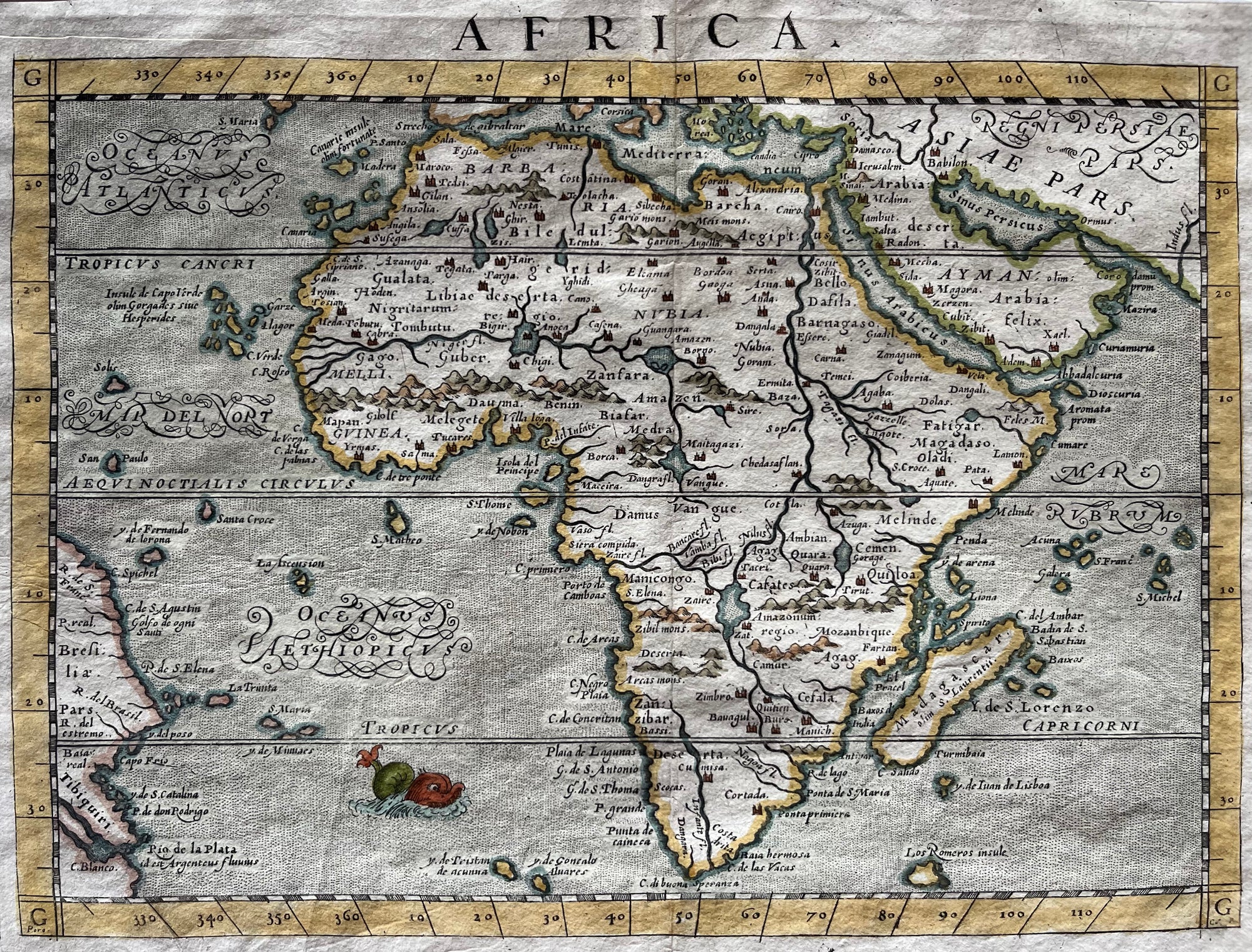
Africa
Sold Out
|
/
Quick Shop
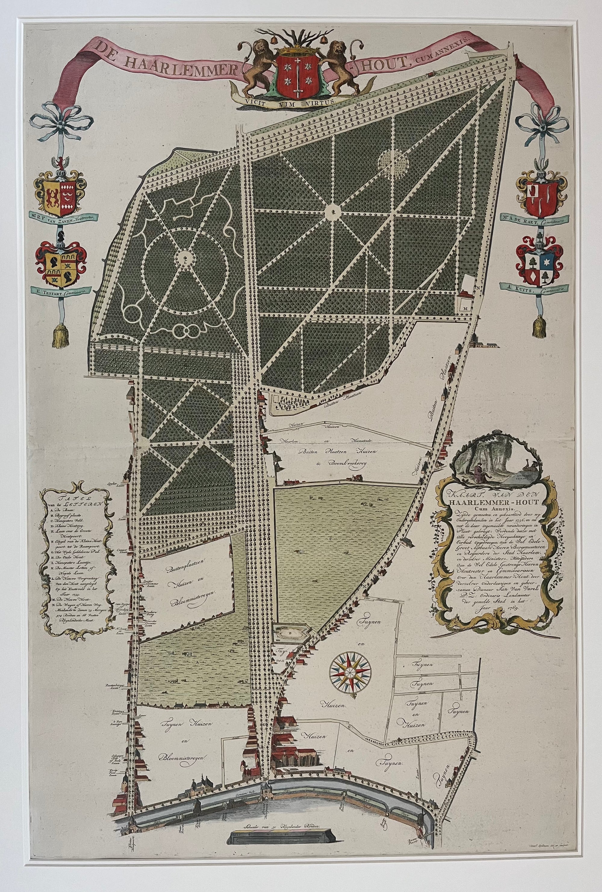
Haarlem - De Hout
€1,750.00
|
/
Quick Shop
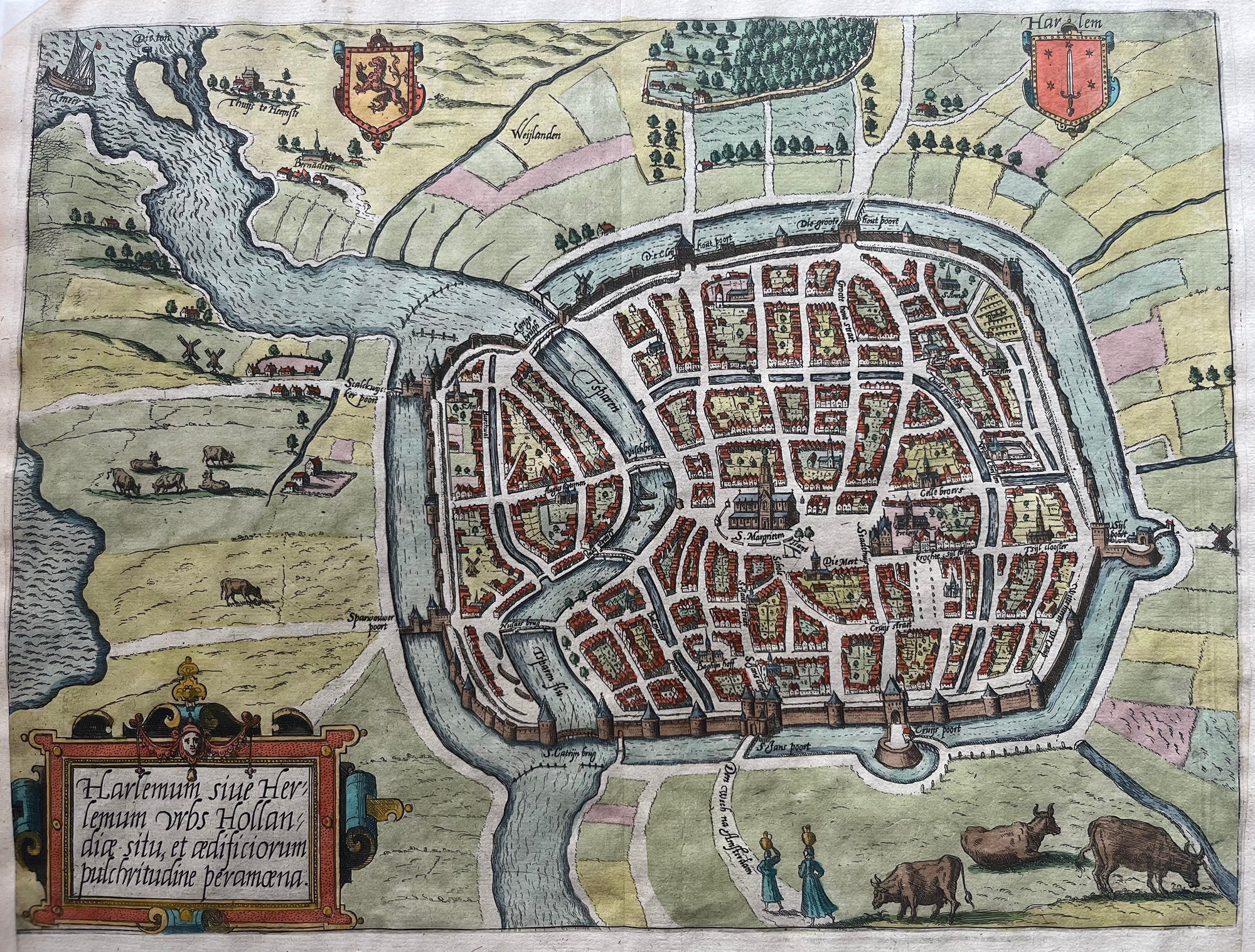
Map of Haarlem
Sold Out
|
/
Quick Shop
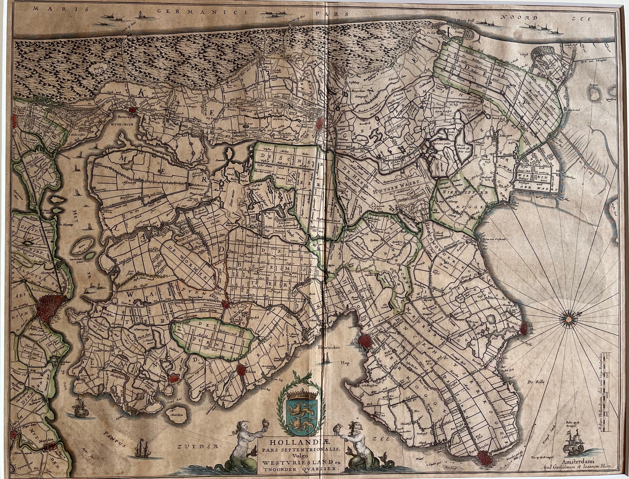
Noord Holland - Westfriesland
Sold Out
|
/
Quick Shop
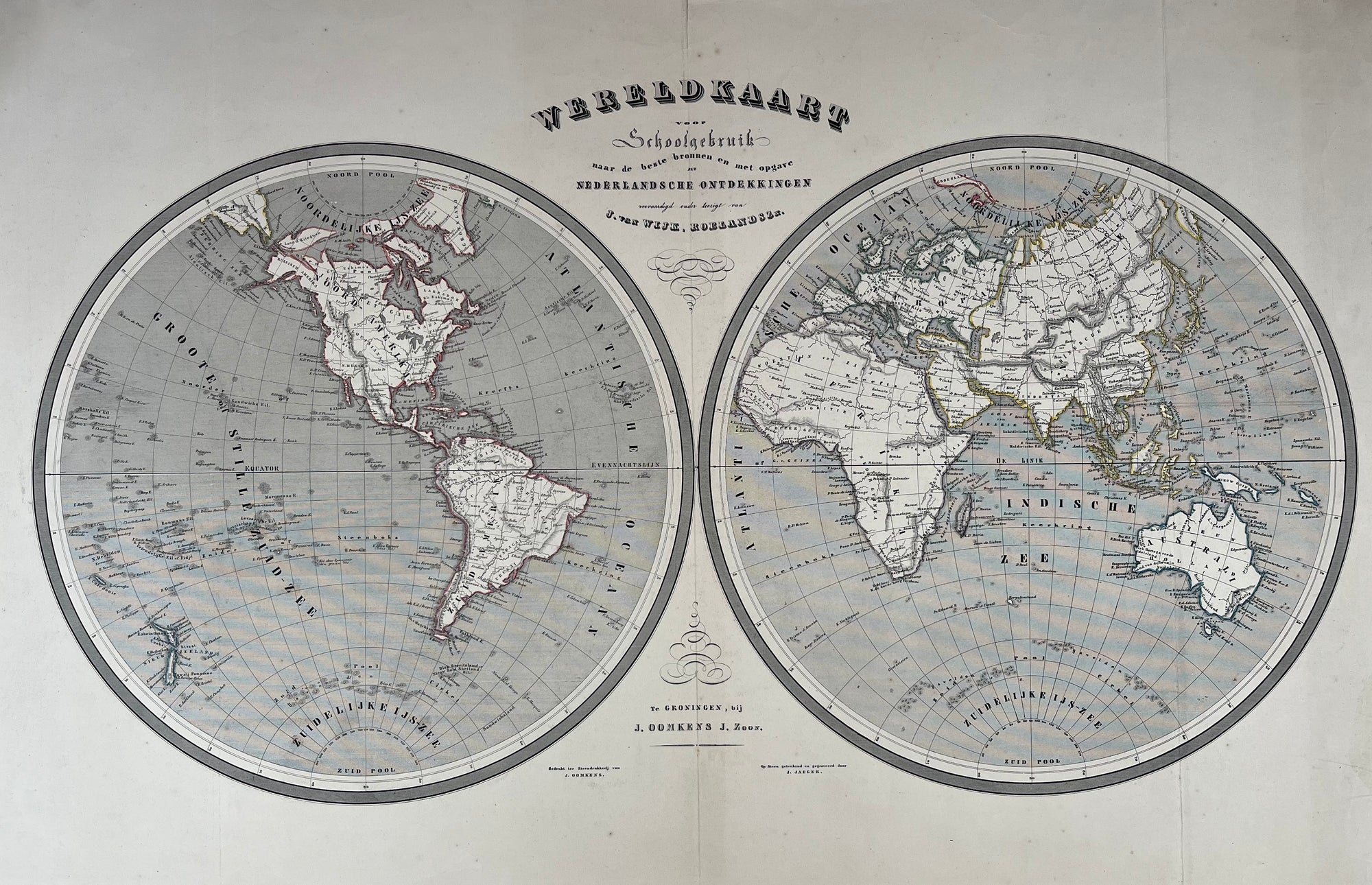
Worldmap
€300.00
|
/
Quick Shop
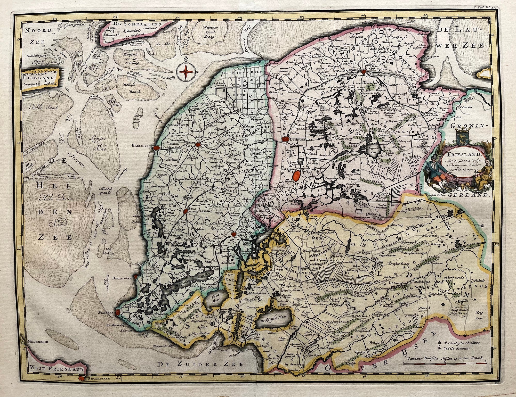
Friesland
Sold Out
|
/
Quick Shop
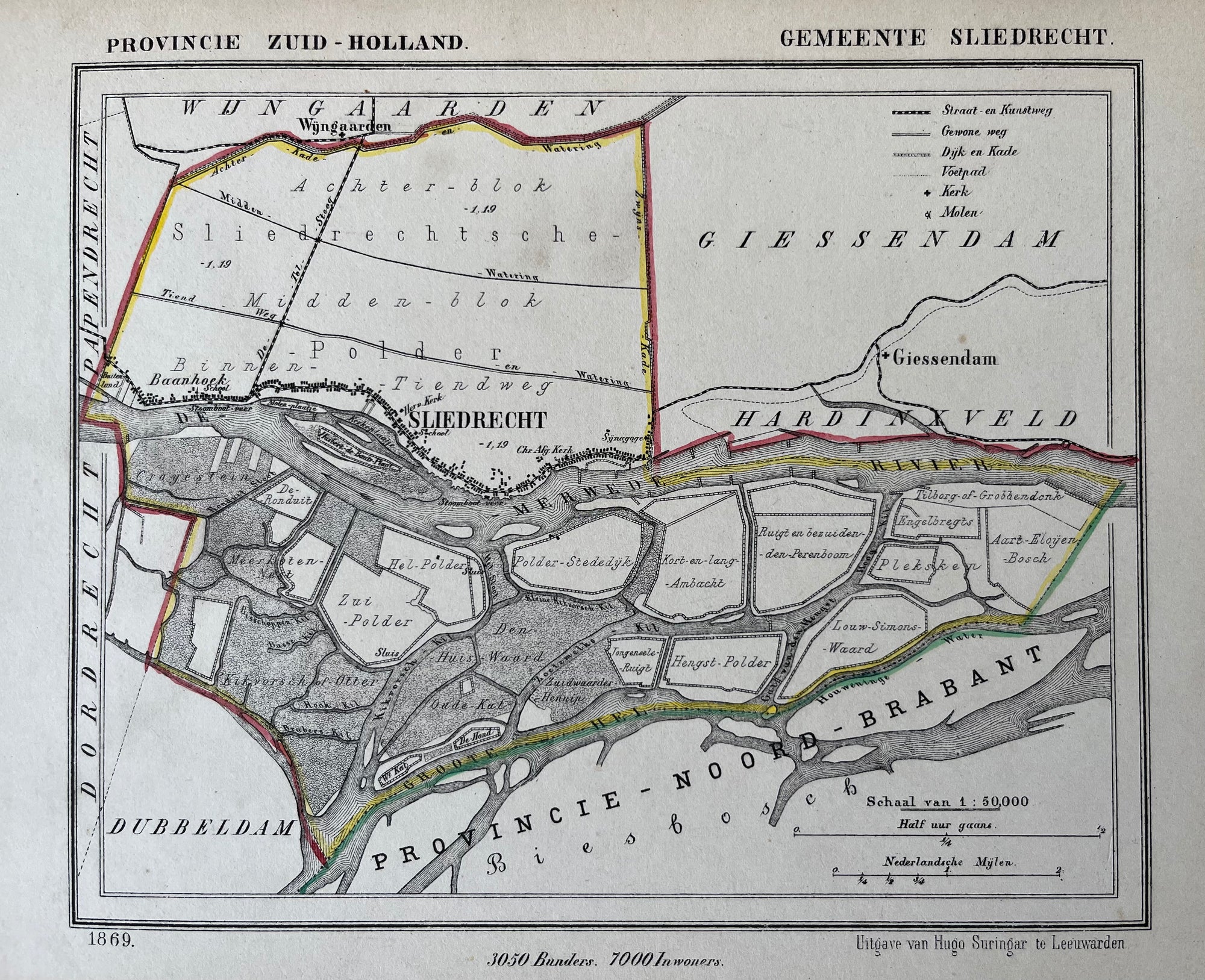
Sliedrecht
€75.00
|
/
Quick Shop
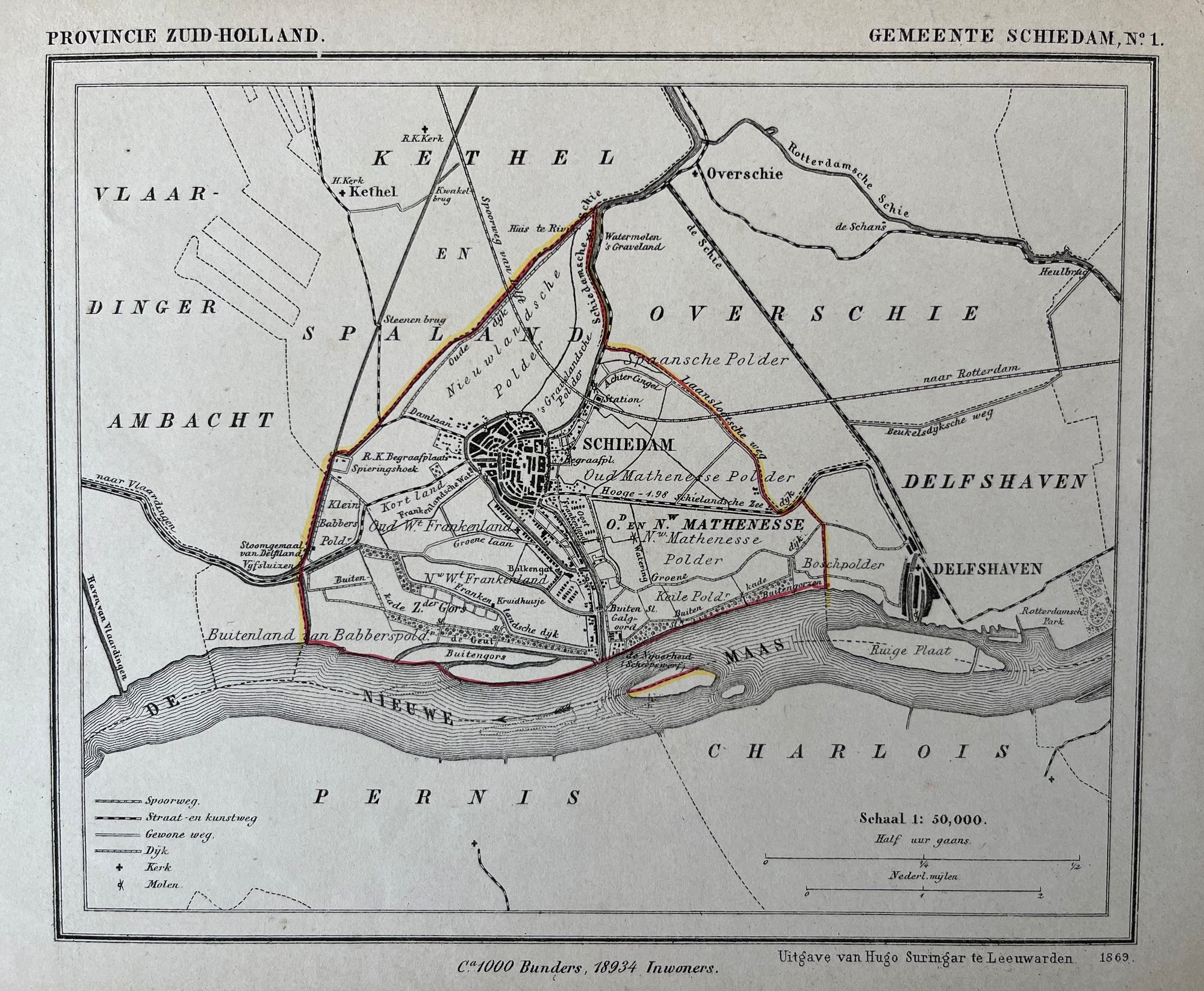
Schiedam
€90.00
|
/
Quick Shop
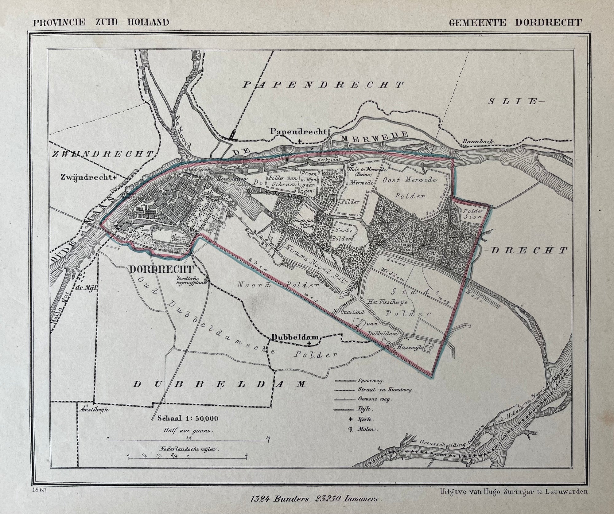
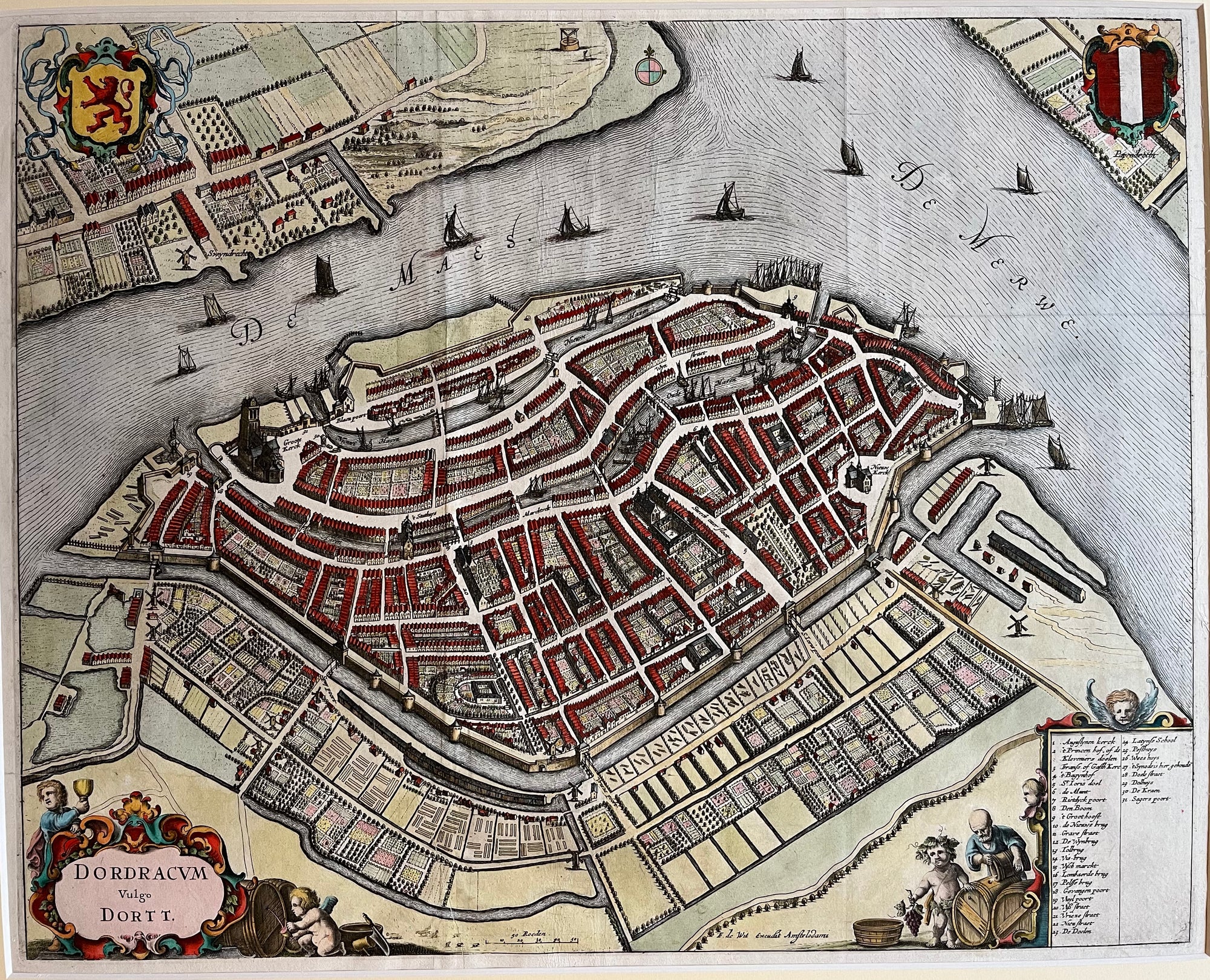
Dordrecht
€90.00
|
/
Quick Shop
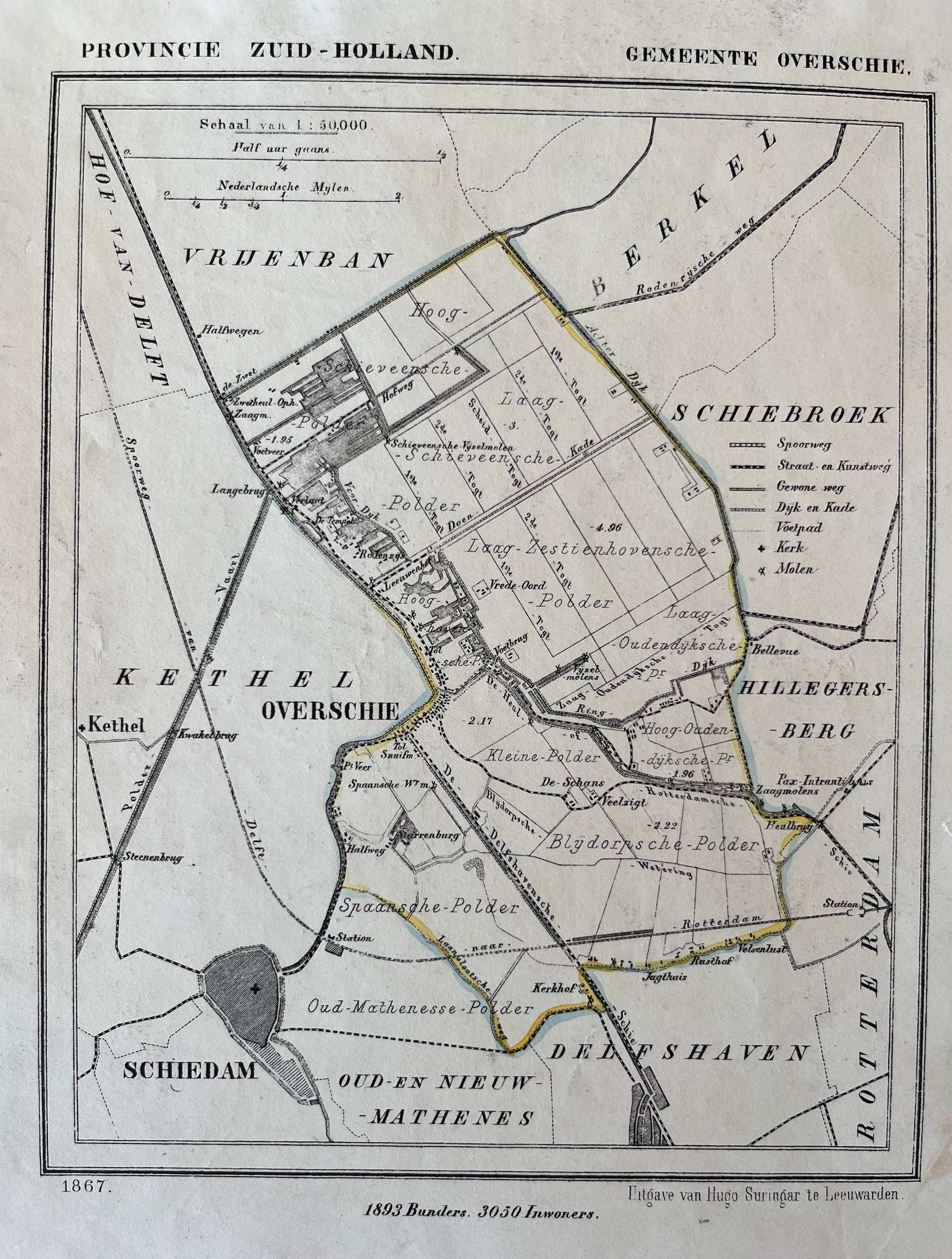
Overschie
Sold Out
|
/
Quick Shop
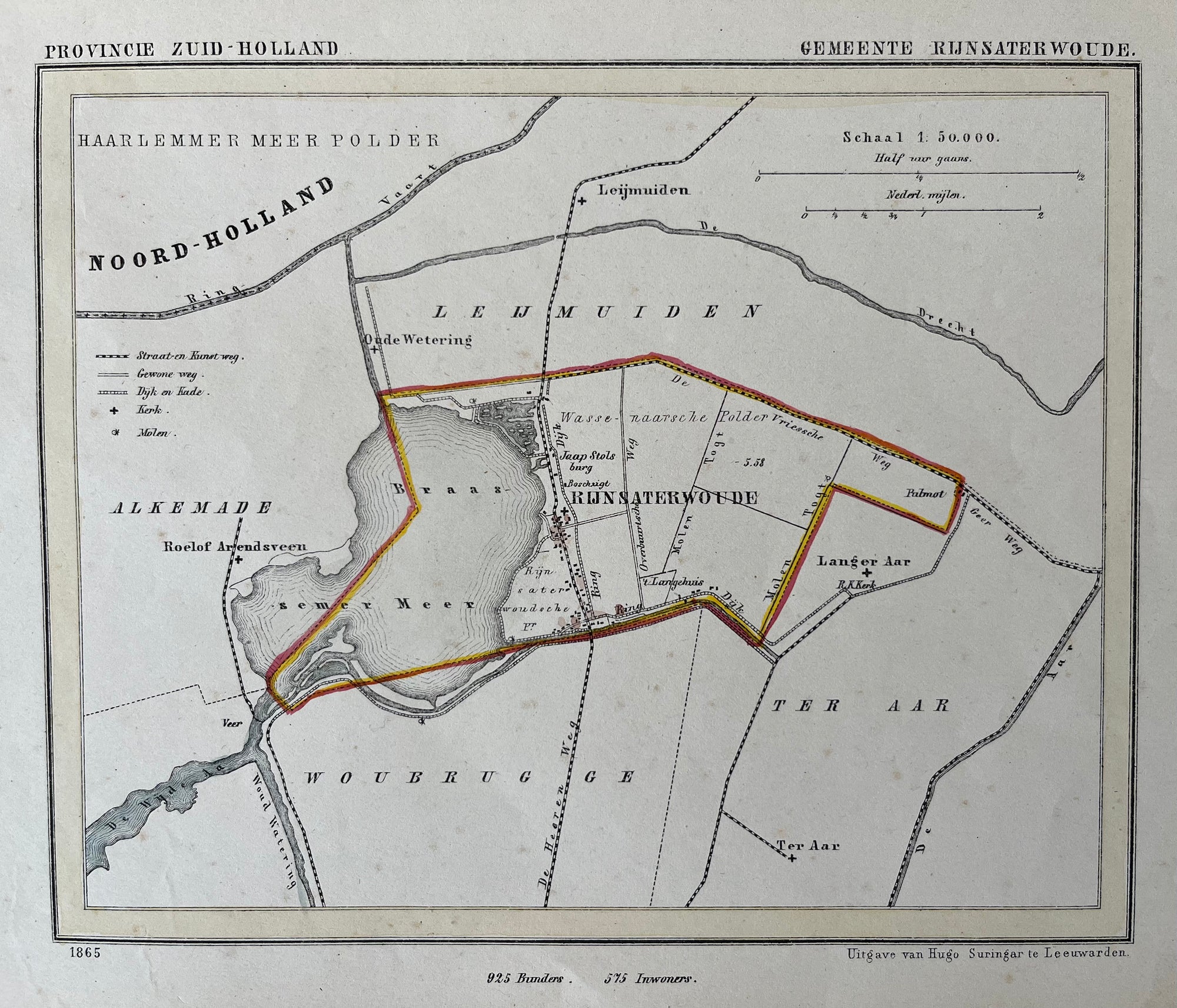
Rijnsaterwoude
Sold Out
|
/
Quick Shop
Voorhout
Sold Out
|
/
Quick Shop
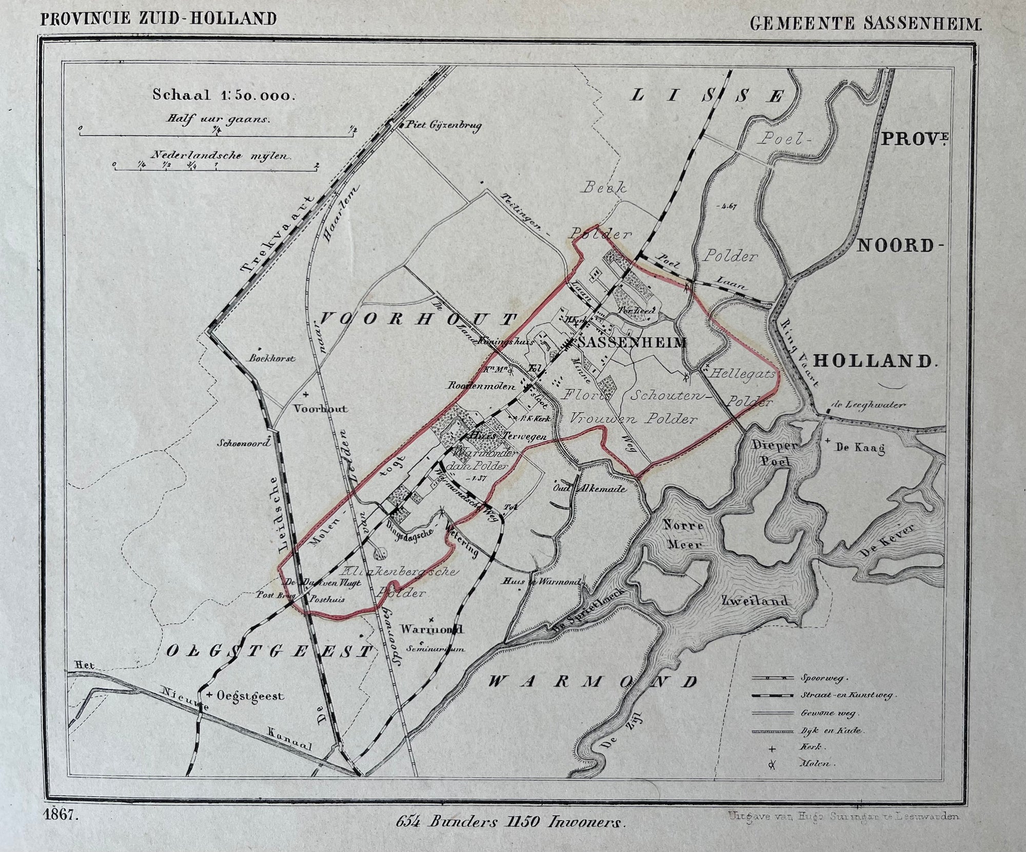
Sassenheim
€90.00
|
/
Quick Shop
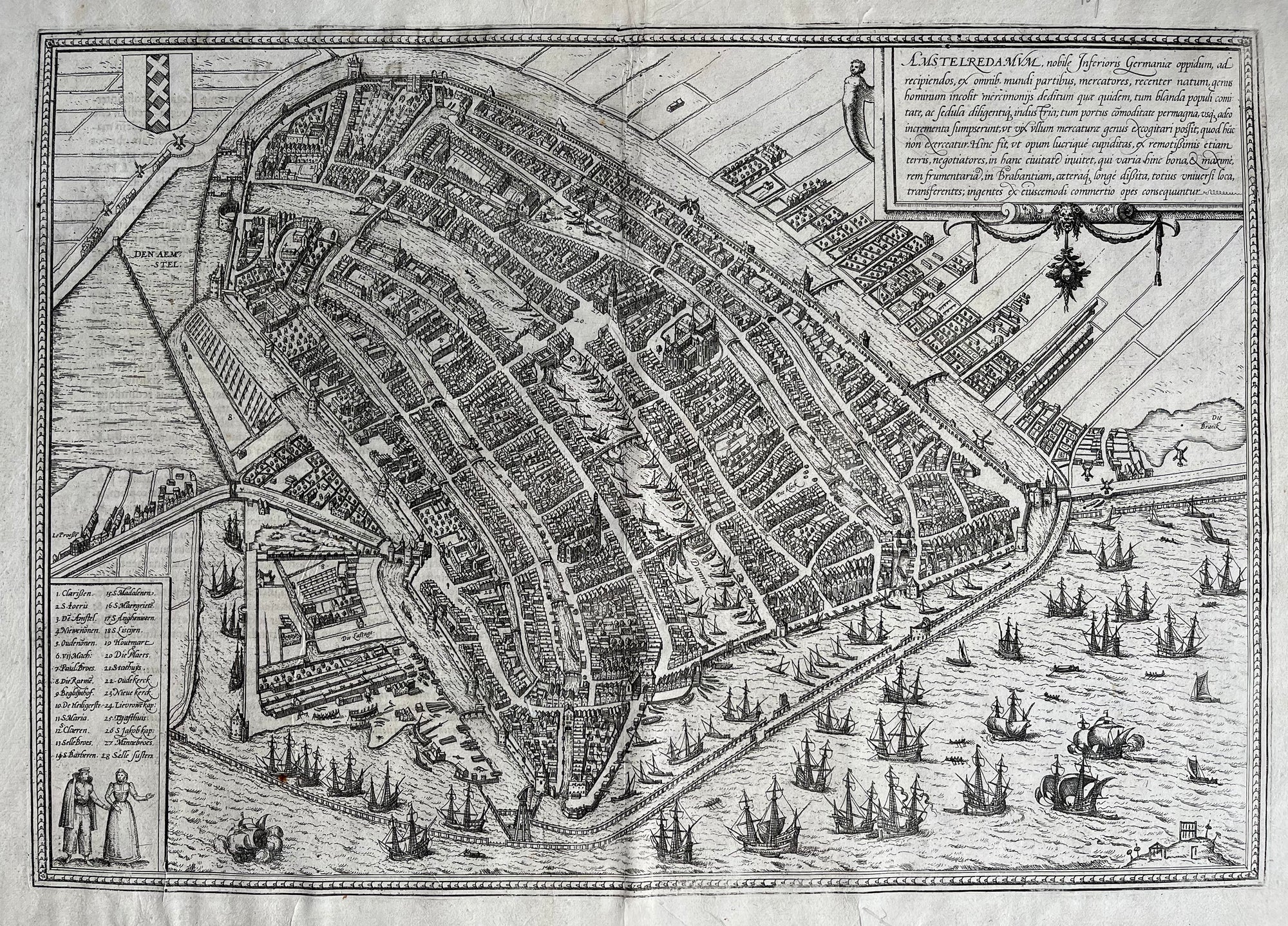
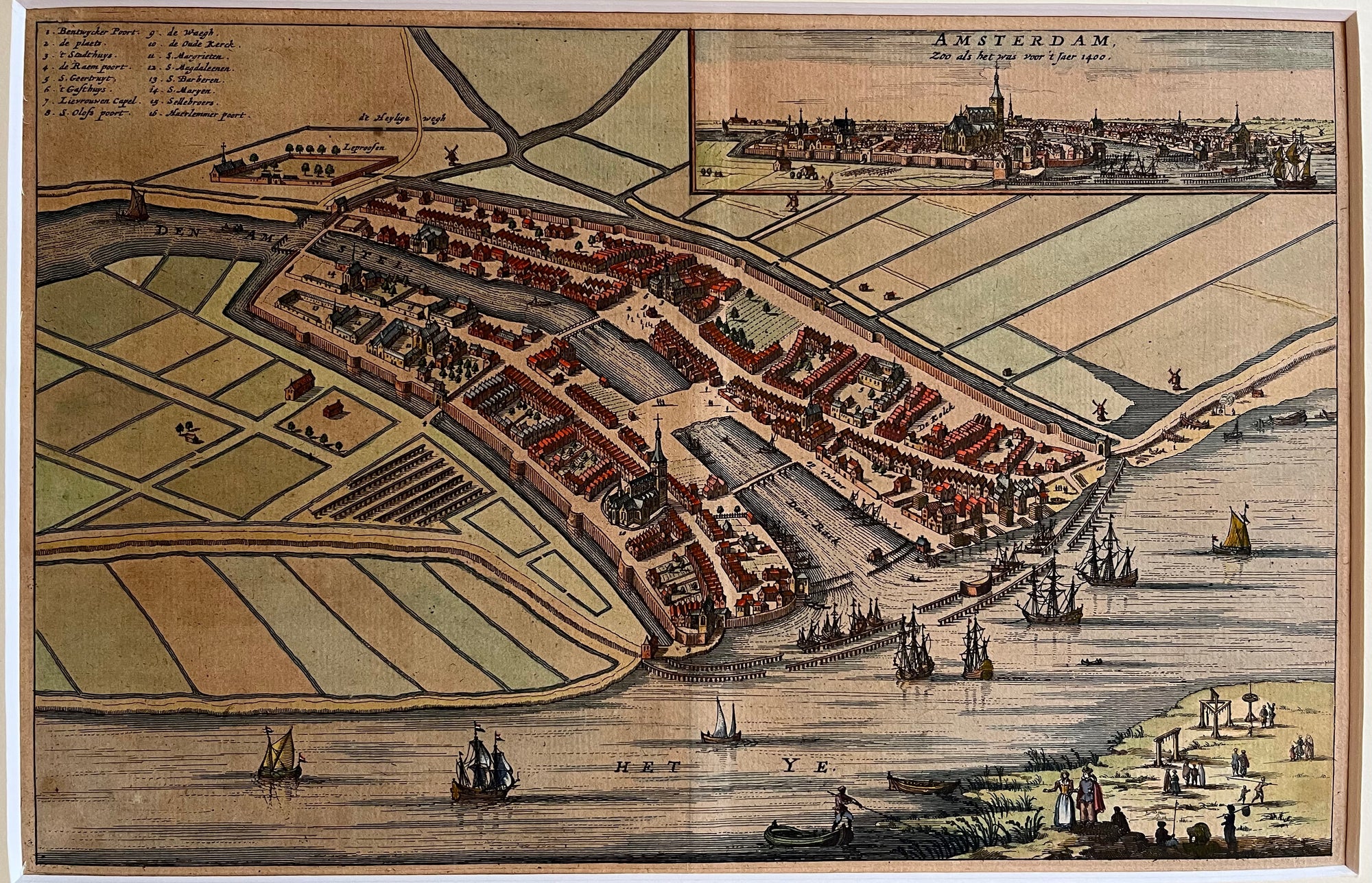
Amsterdam 1572
Sold Out
|
/
Quick Shop
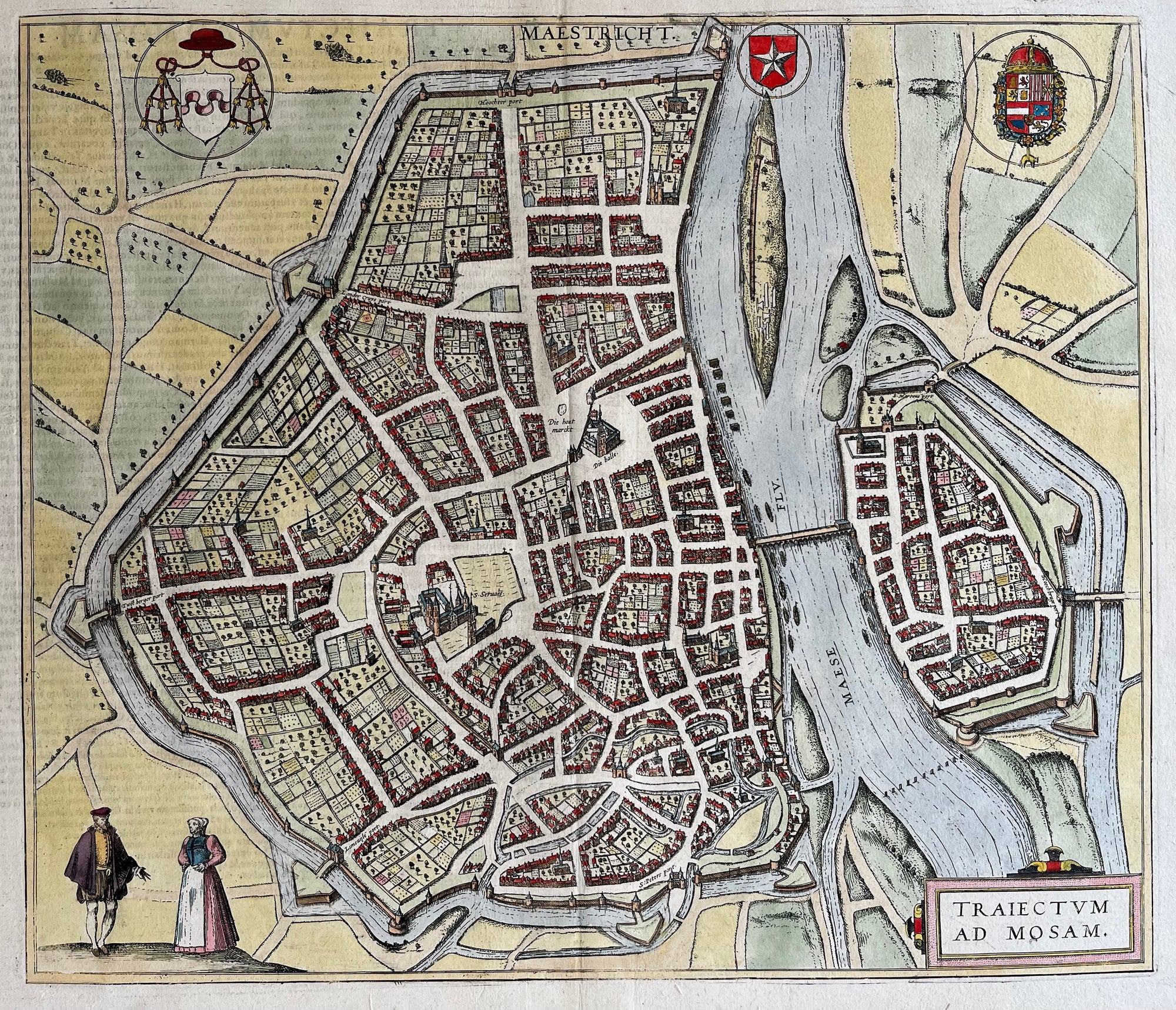
Map of Maastricht by Blaeu
€1,400.00
|
/
Quick Shop
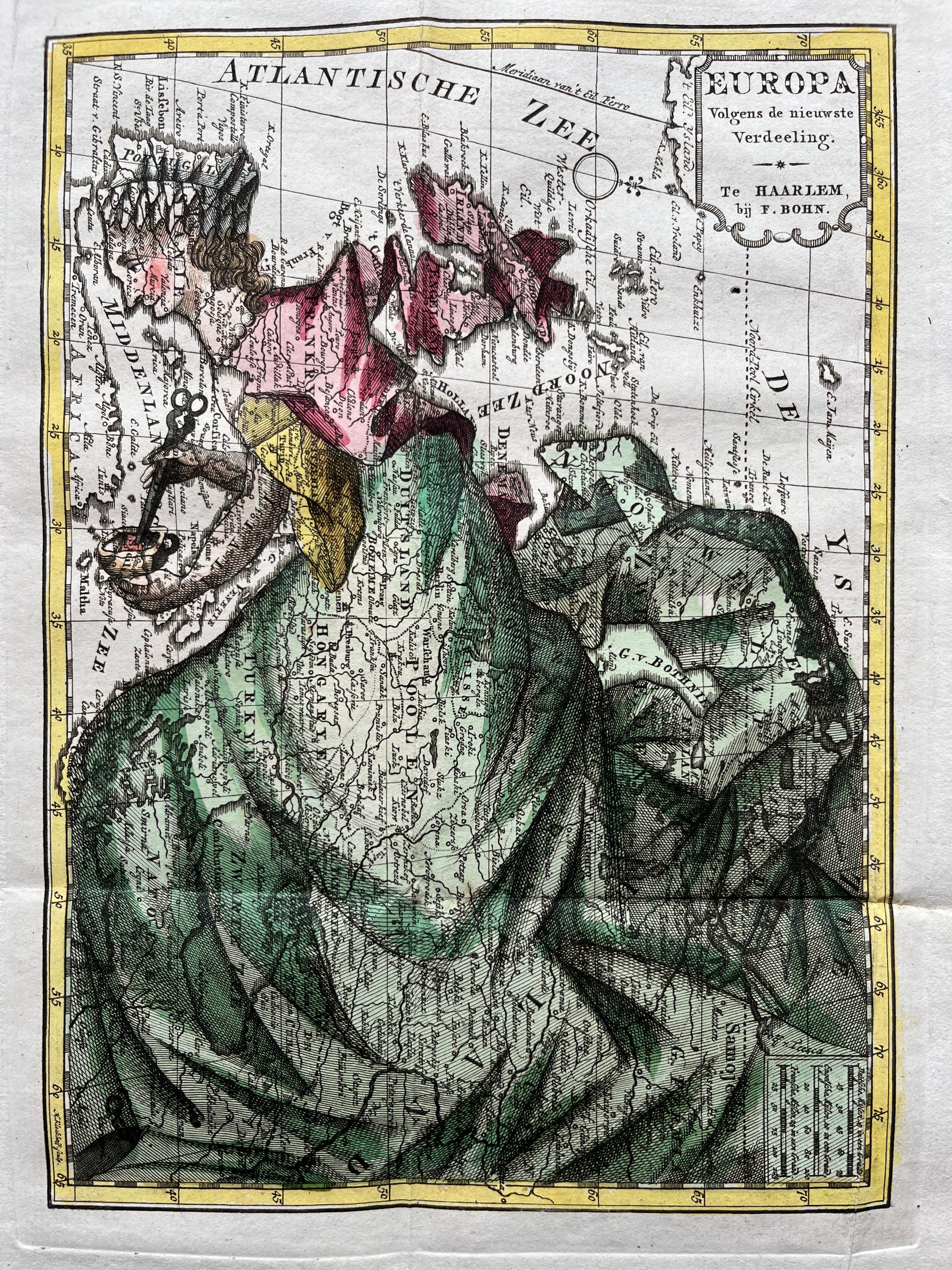
Europe as a queen
Sold Out
|
/
Quick Shop
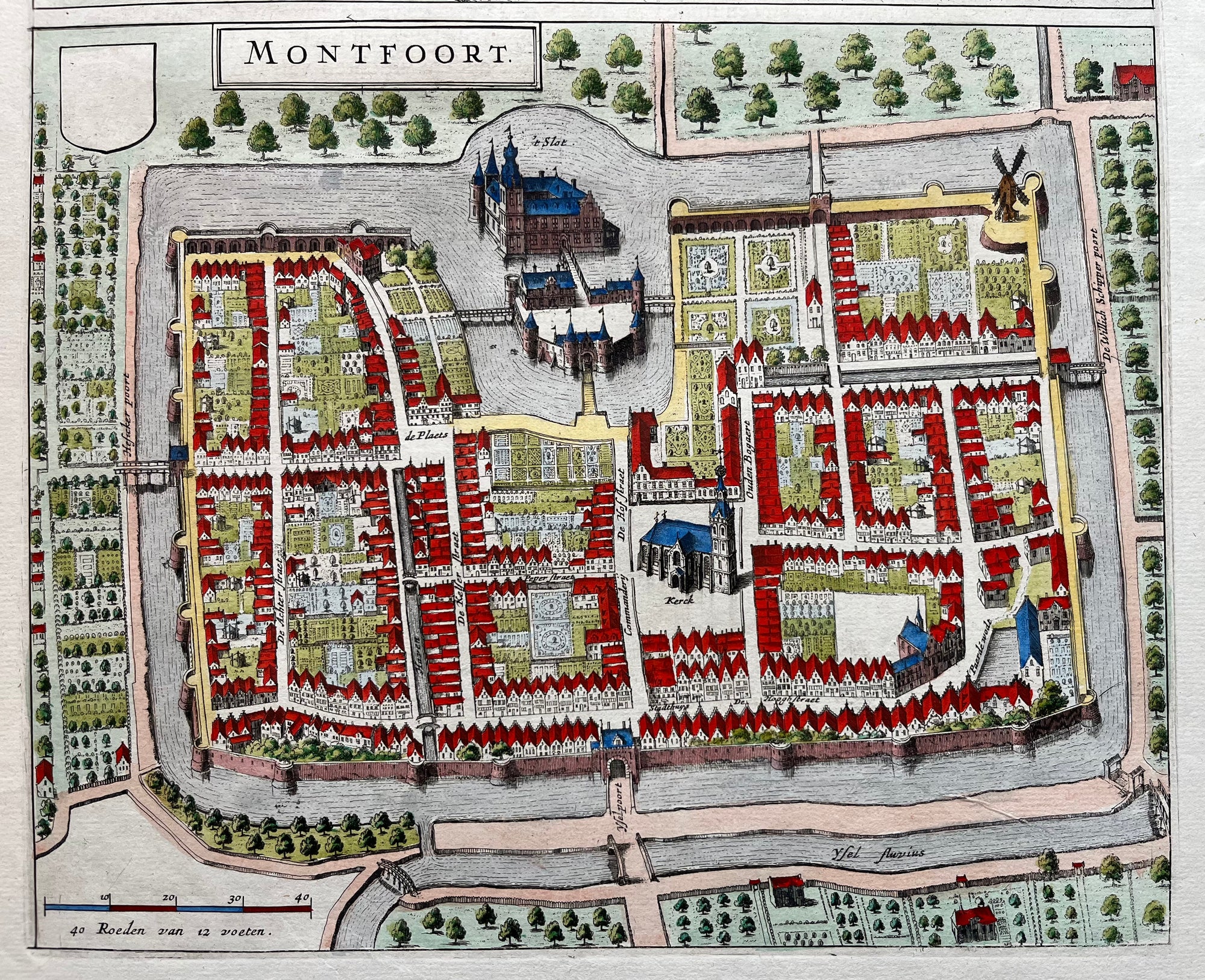
Montfoort
€170.00
|
/
Quick Shop
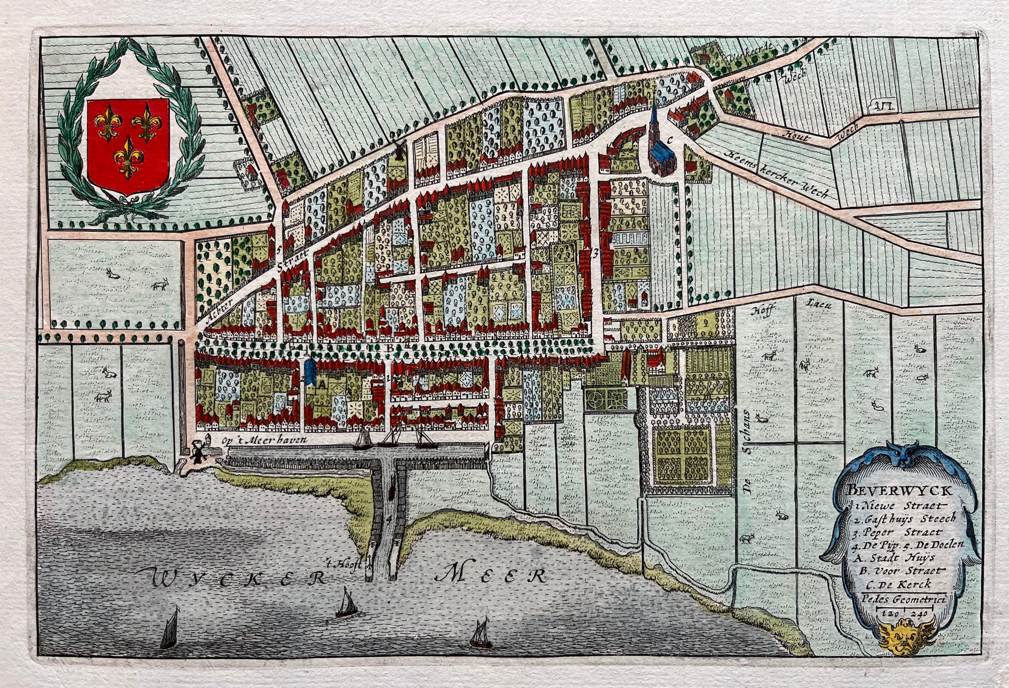
Map of Beverwijk
Sold Out
|
/
Quick Shop
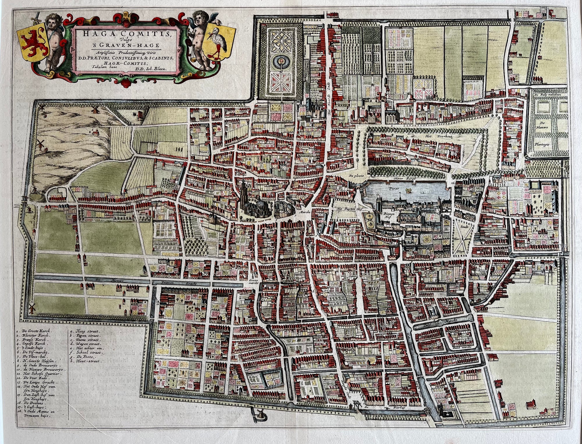
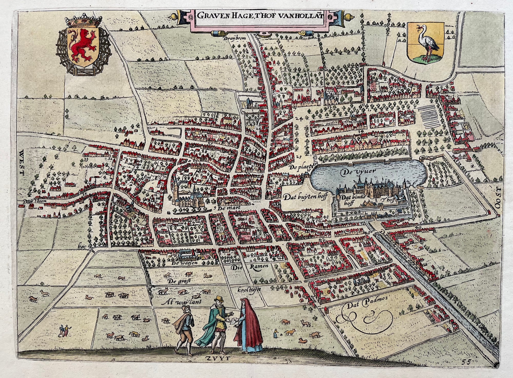
Map of The Hague
Sold Out
|
/
Quick Shop
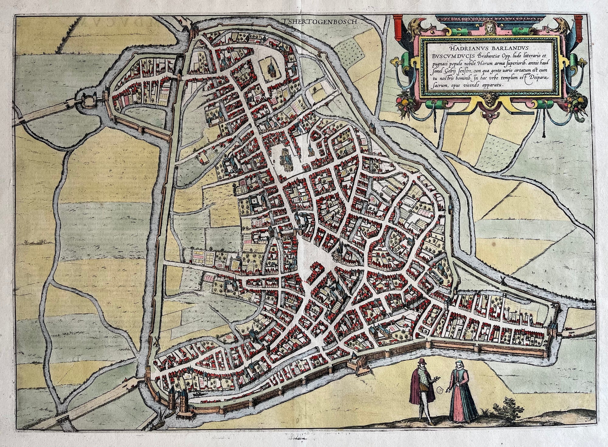
Map of 's-Hertogenbosch
€800.00
|
/
Quick Shop
16th century map of Maastricht
Sold Out
|
/
Quick Shop
Map of the Netherlands
€275.00
|
/
Quick Shop
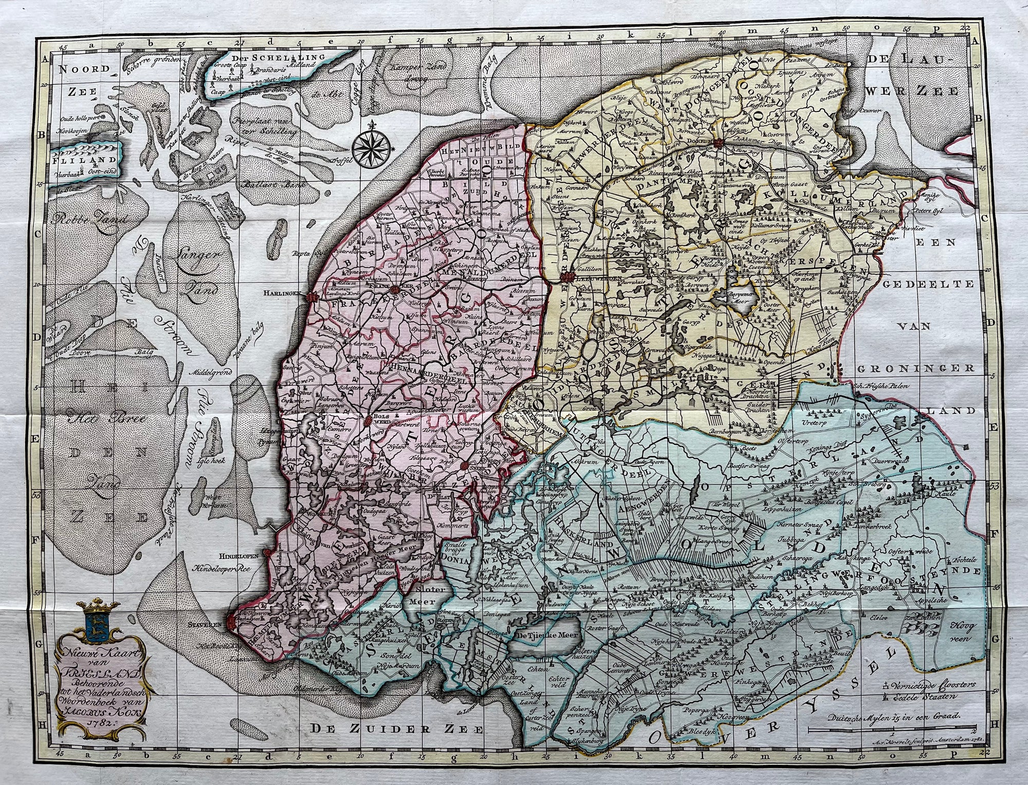
Map of Friesland
€275.00
|
/
Quick Shop
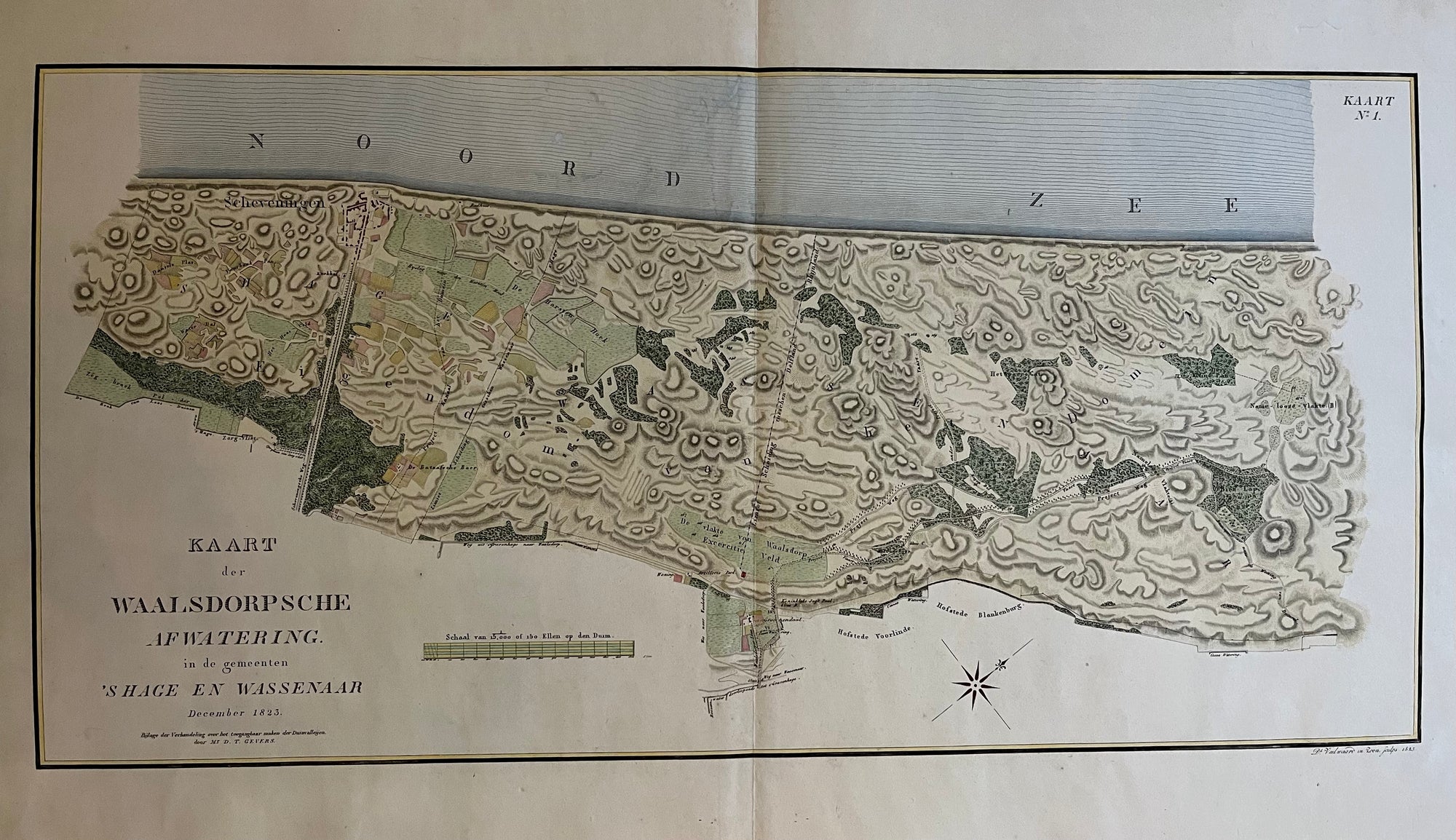
Wassenaar
€600.00
|
/
Quick Shop
Dordrecht
Sold Out
|
/
Quick Shop
Amsterdam in 1400
Sold Out
|
/
Quick Shop
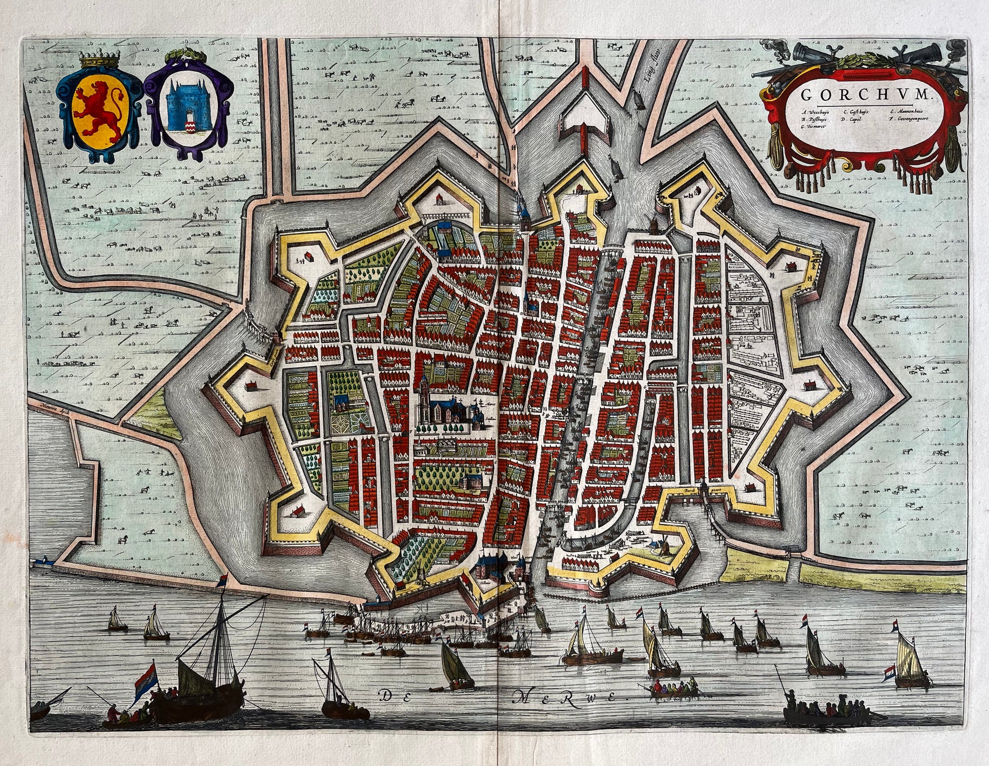
Map of Gorinchem
€550.00
|
/
Quick Shop
Noord Holland ,West- Friesland
Sold Out
|
/
Quick Shop
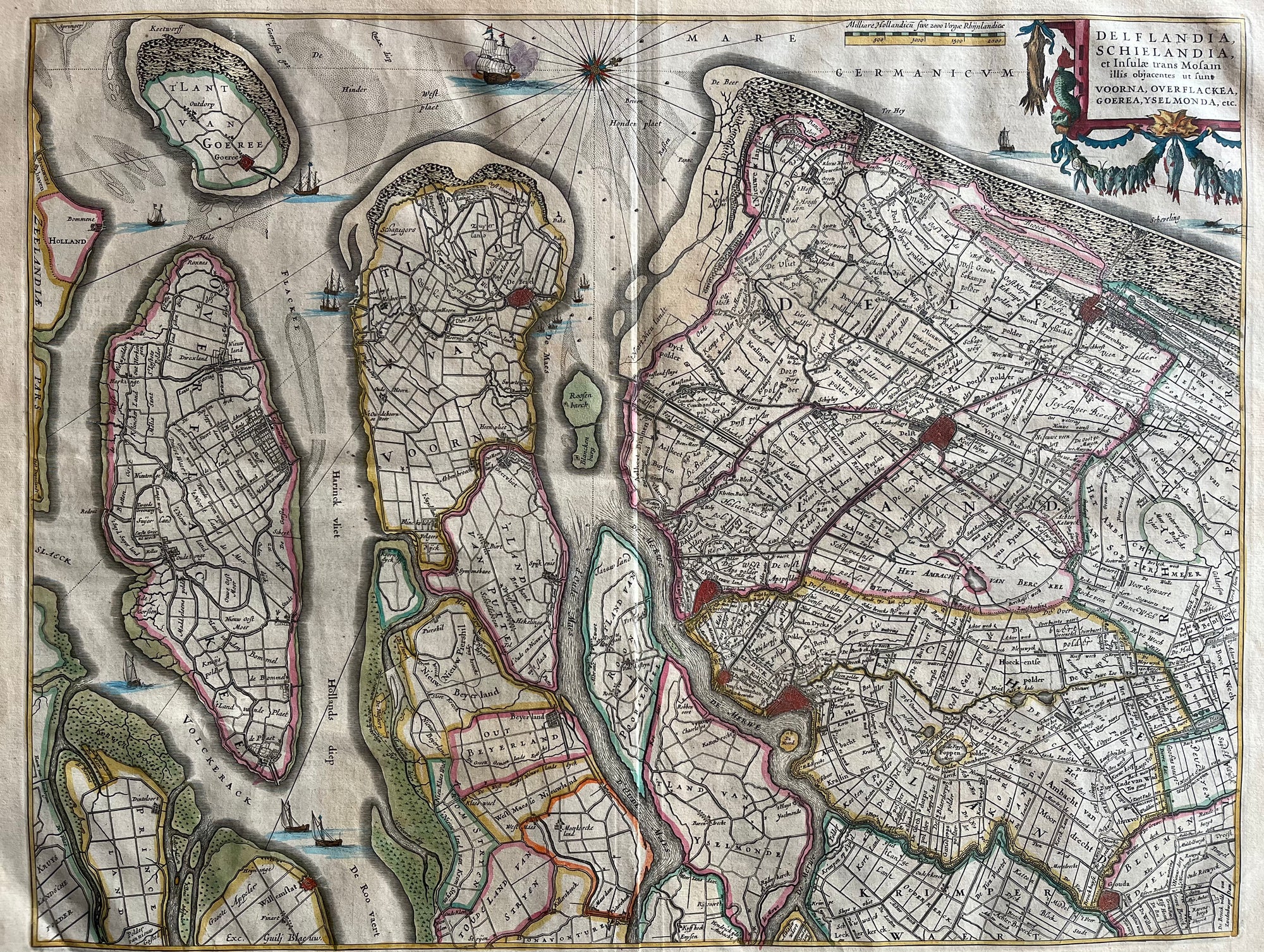
Delfland - Schieland
Sold Out
|
/
Quick Shop
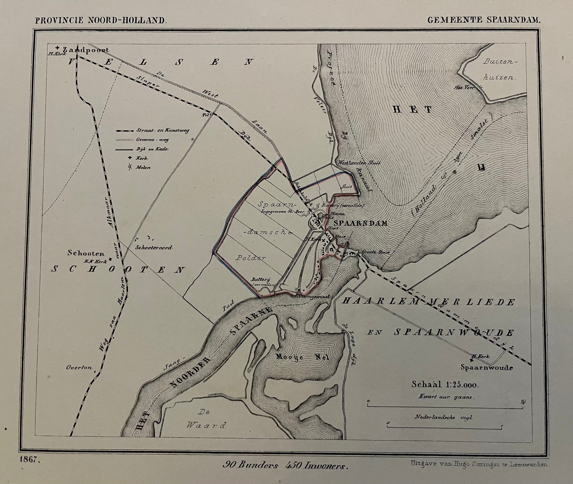
Gemeente Spaarndam
€90.00
|
/
Quick Shop
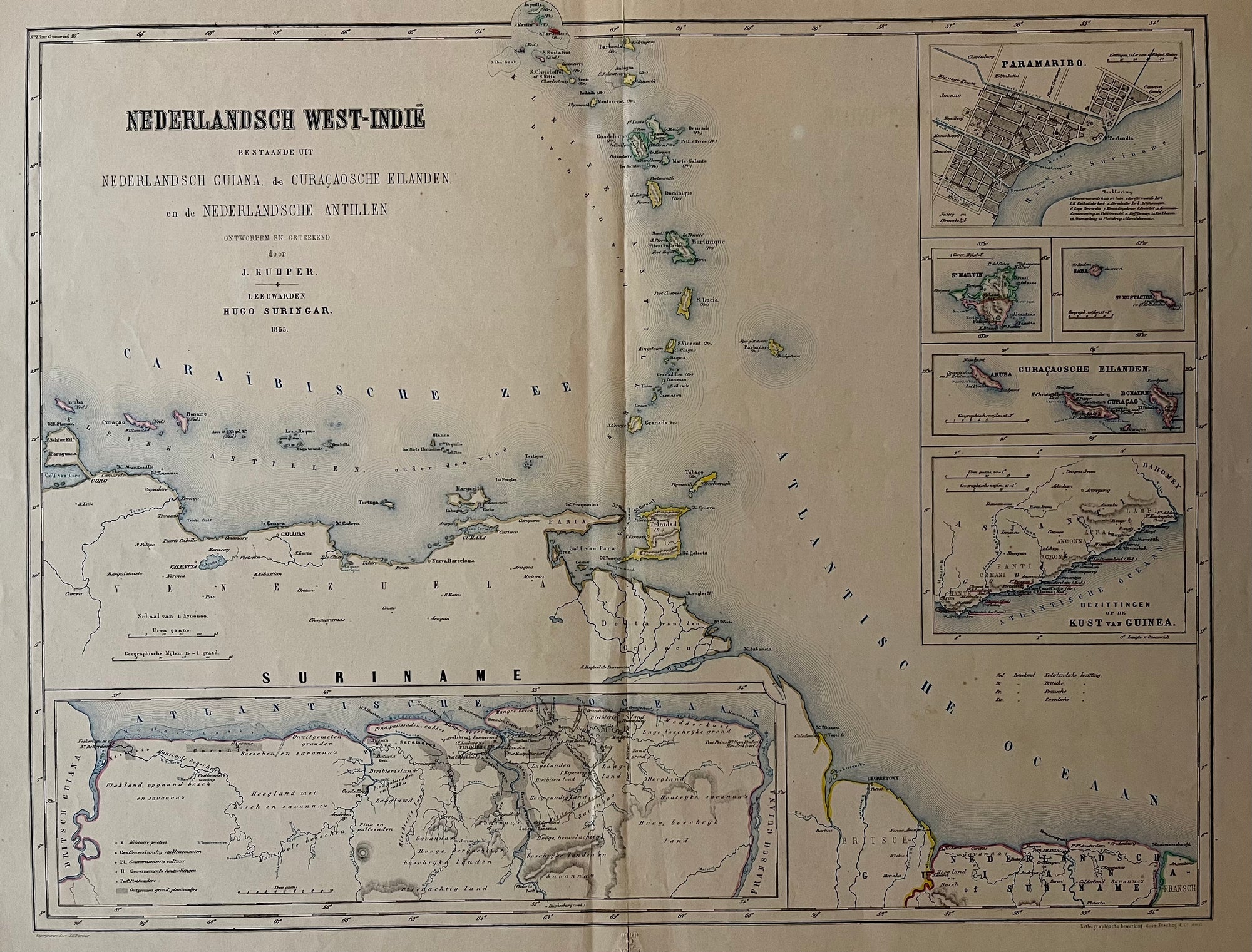
Suriname Guiana Curacao
€185.00
|
/
Quick Shop
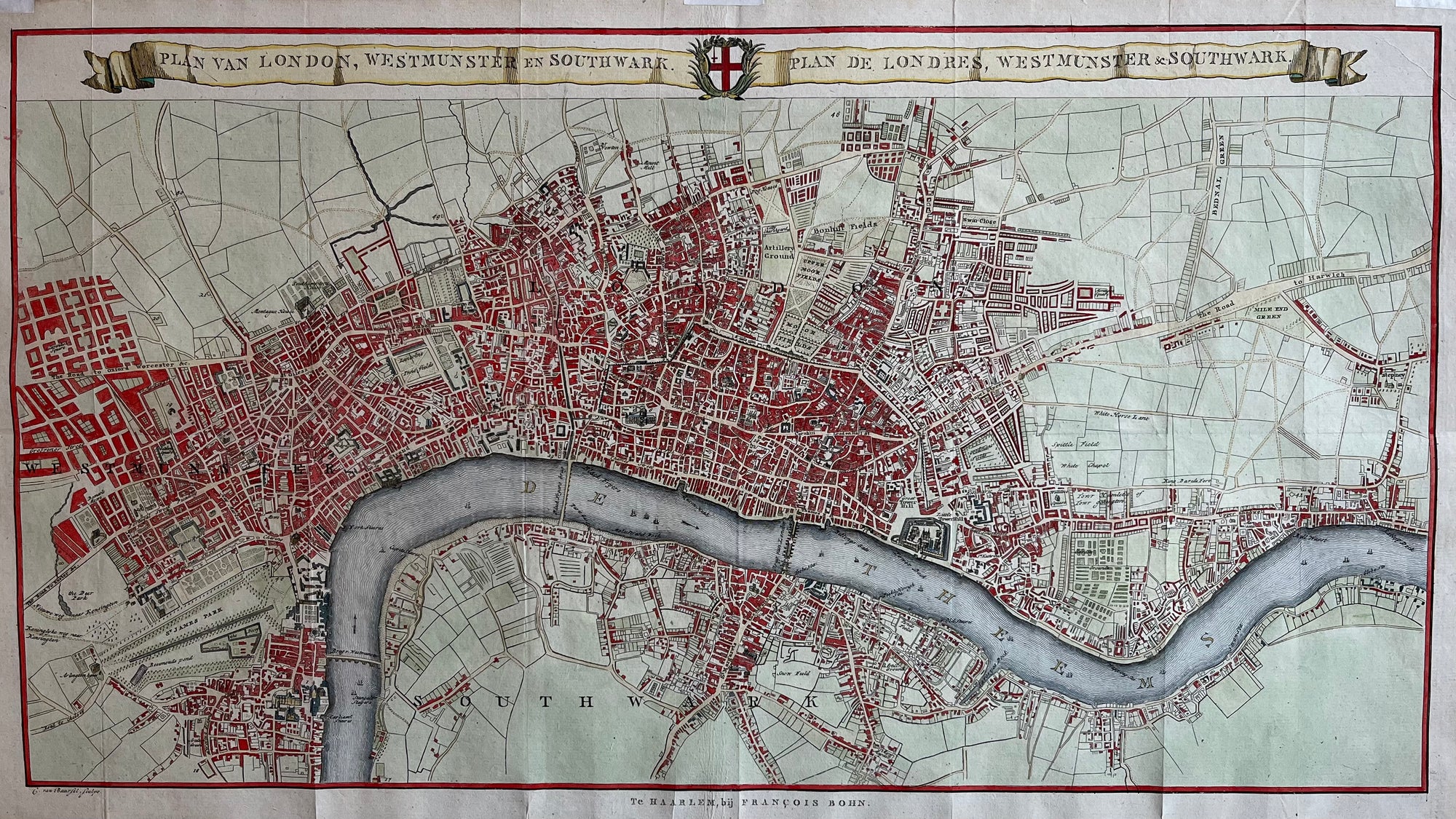
Map of London
€1,100.00
|
/
Quick Shop
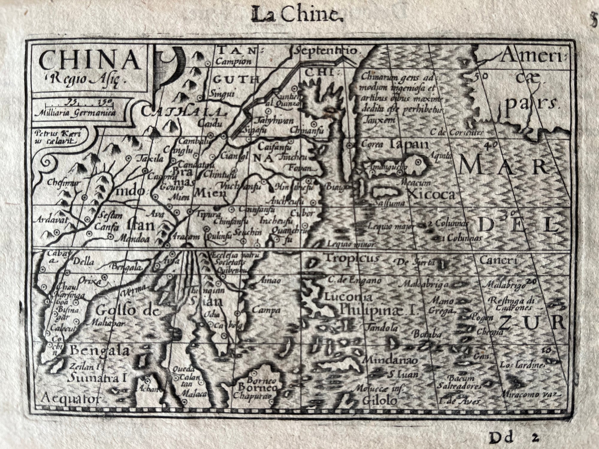
China 1598
€525.00
|
/
Quick Shop
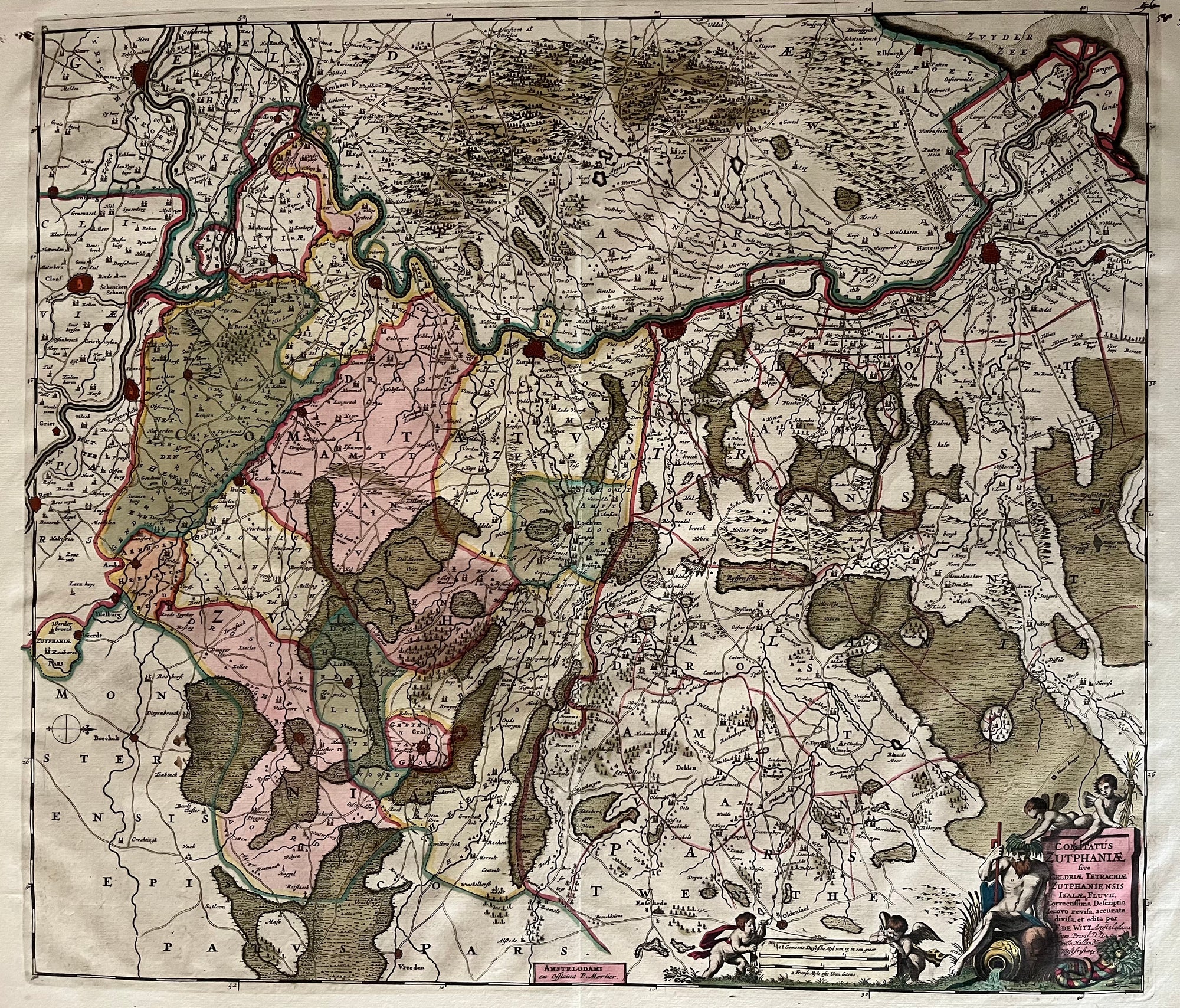
Comitatus Zutphaniae
Sold Out
|
/
Quick Shop
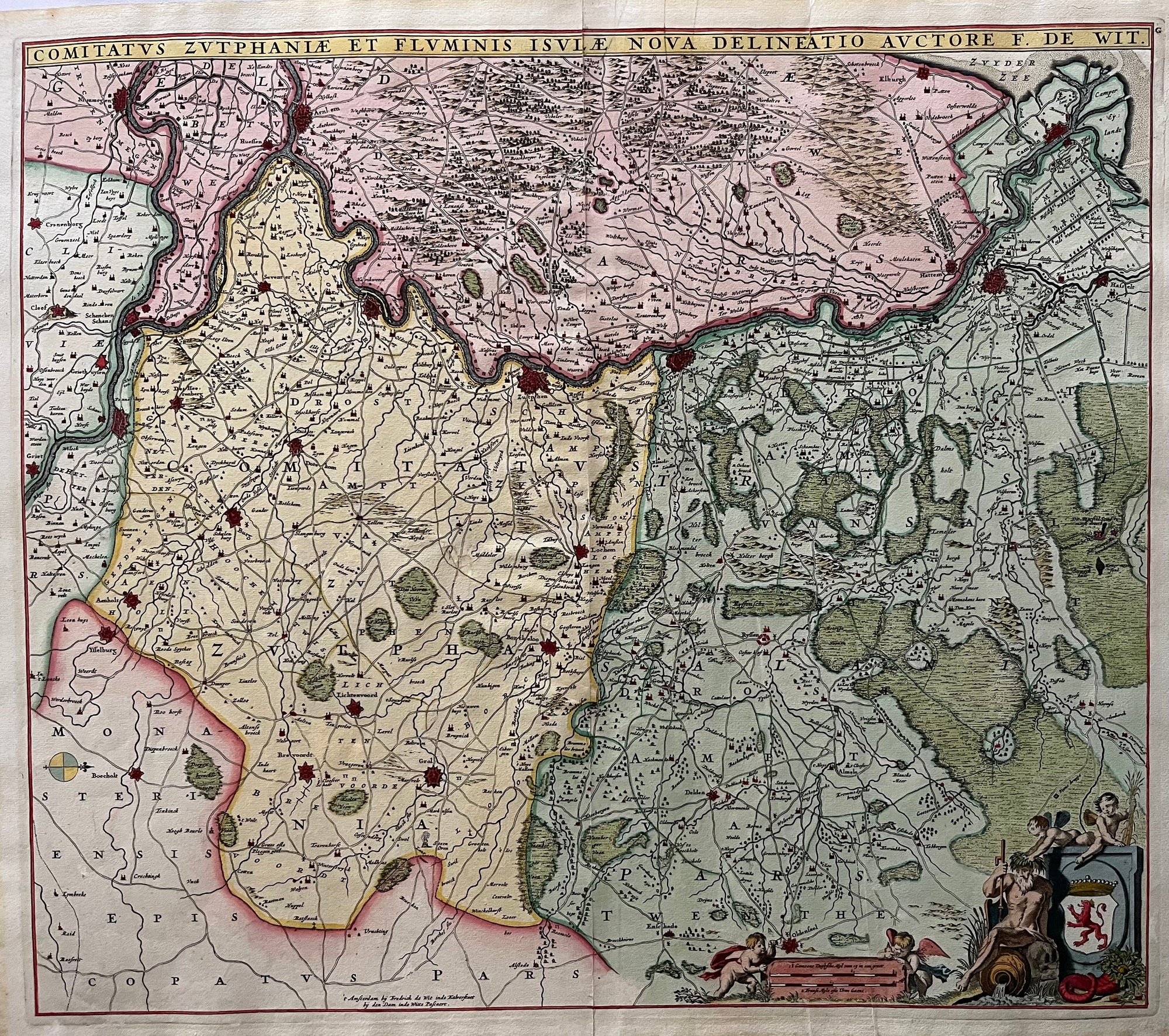
Gelderland by De Wit
€400.00
|
/
Quick Shop
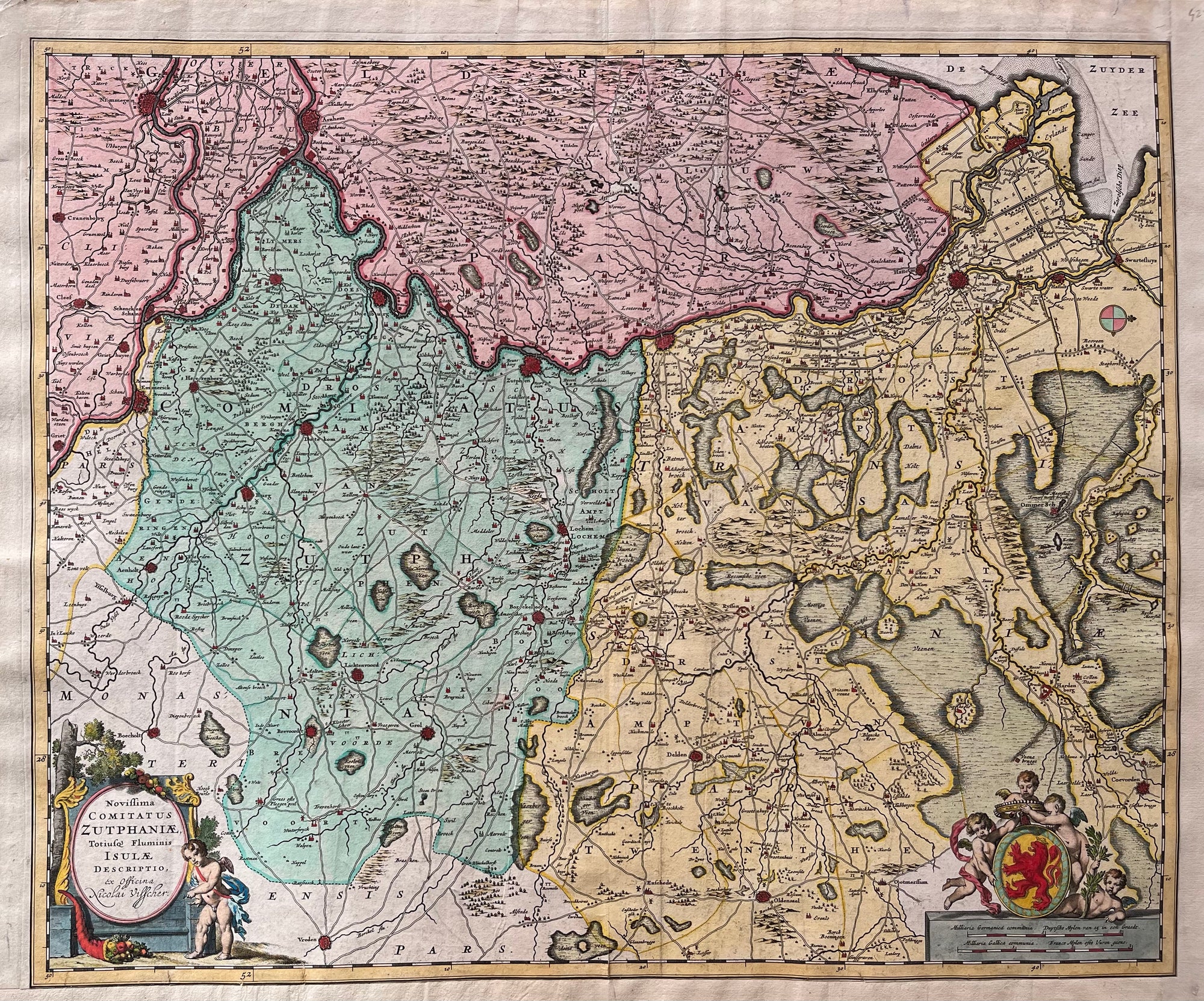
Map of Gelderland
€450.00
|
/
Quick Shop
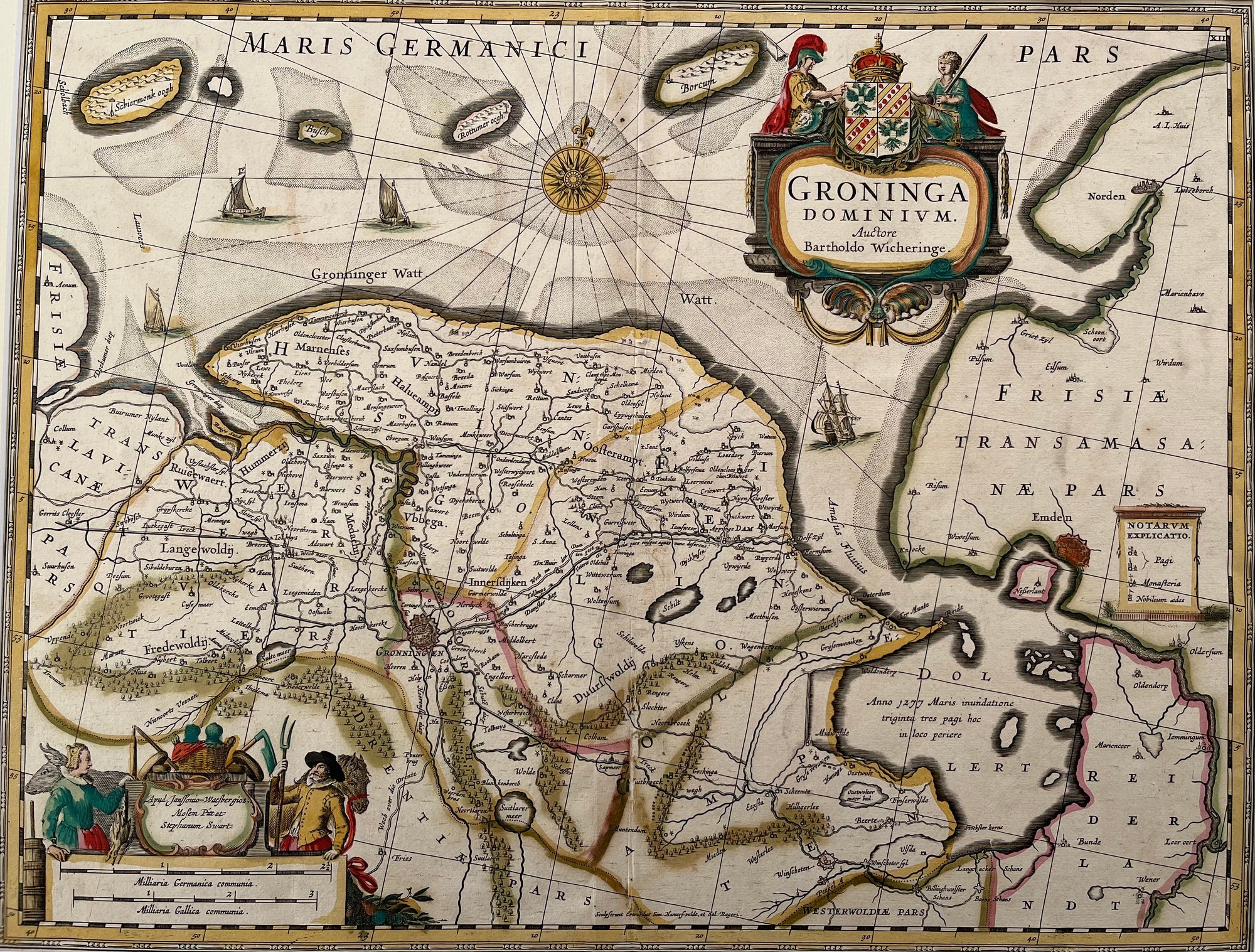
Groningen
€450.00
|
/
Quick Shop
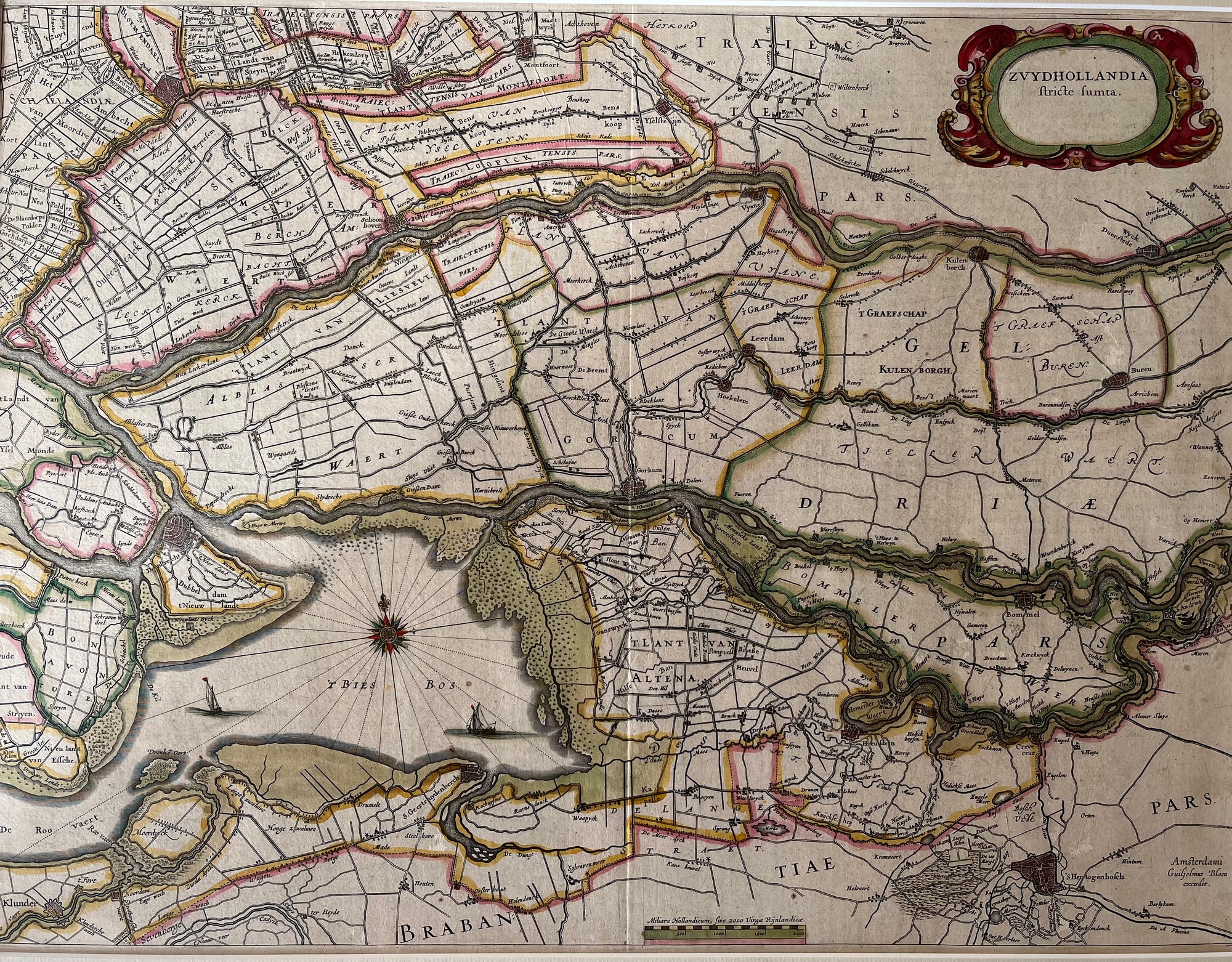
Map of South of Holland
€400.00
|
/
Quick Shop
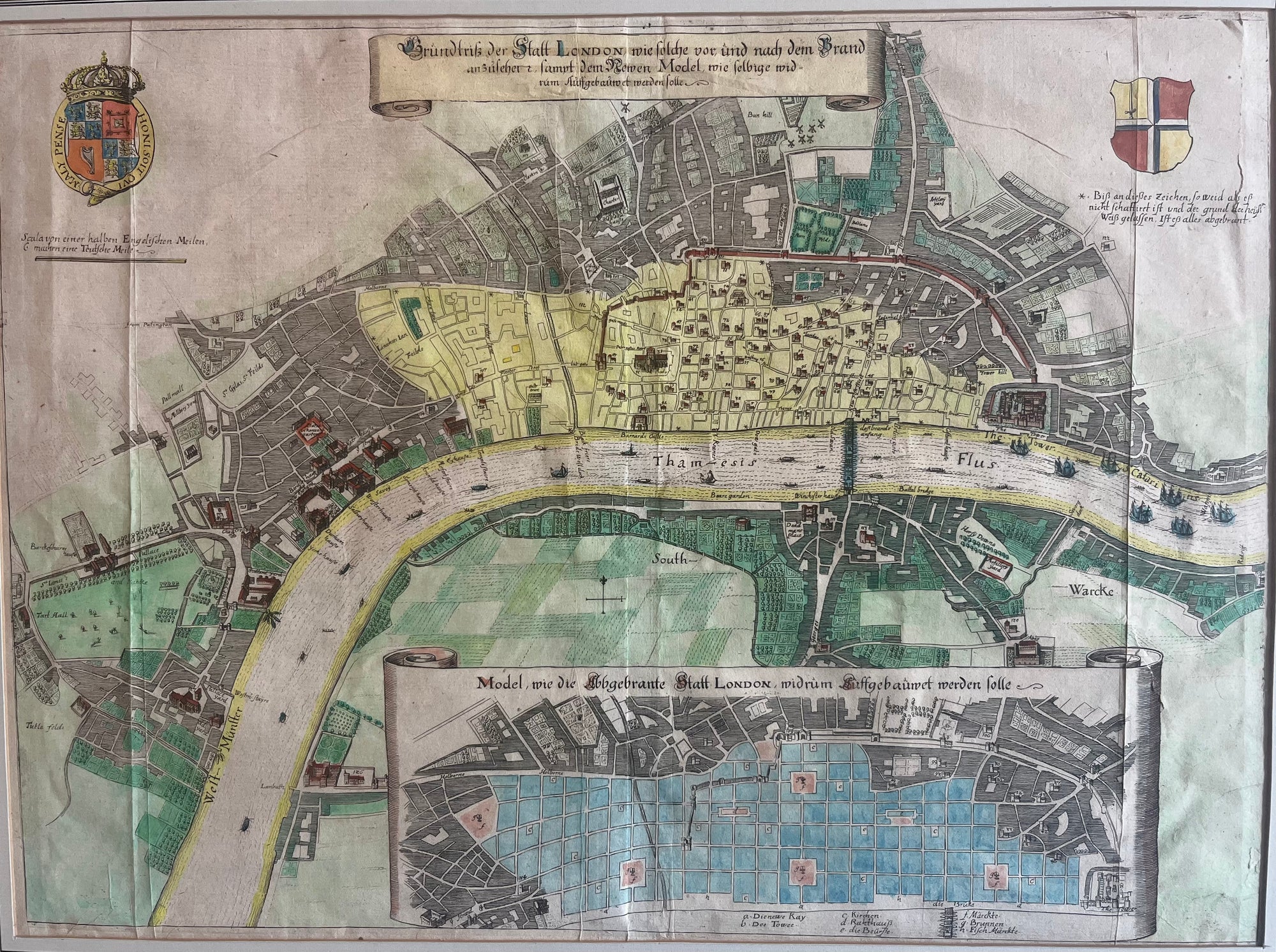
Map of London after the Great Fire
€475.00
|
/
Quick Shop
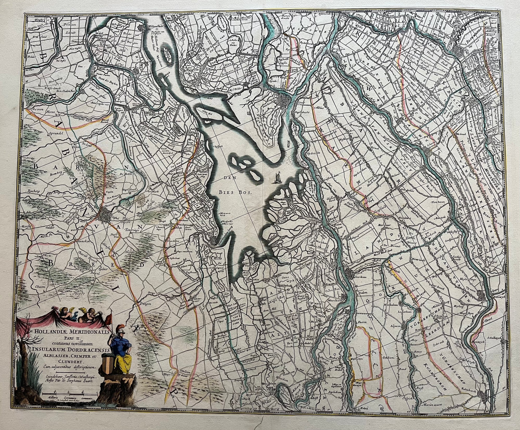
Zuid Holland, Biesbosch, Brabant
€375.00
|
/
Quick Shop
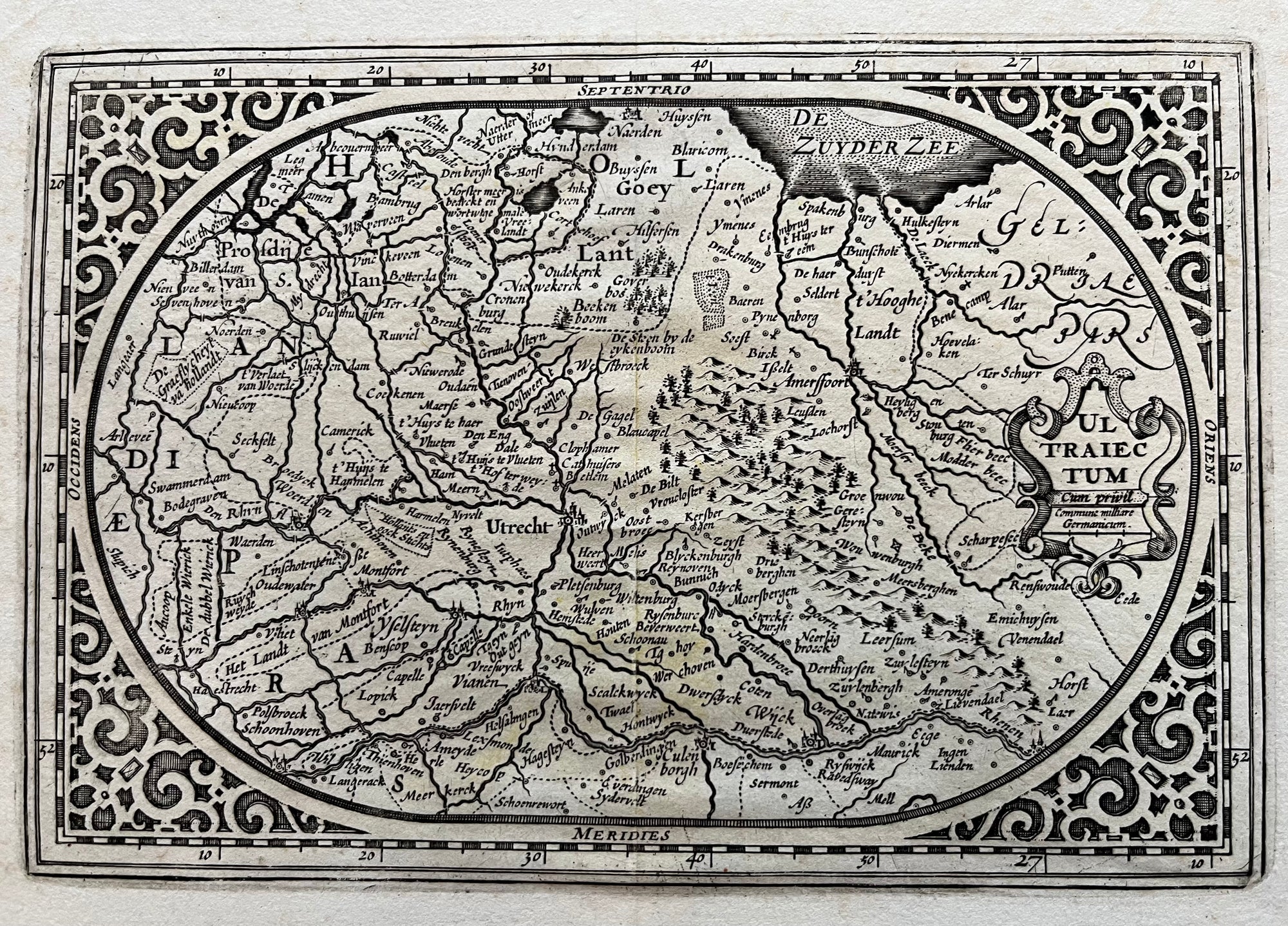
Utrecht region
€200.00
|
/
Quick Shop
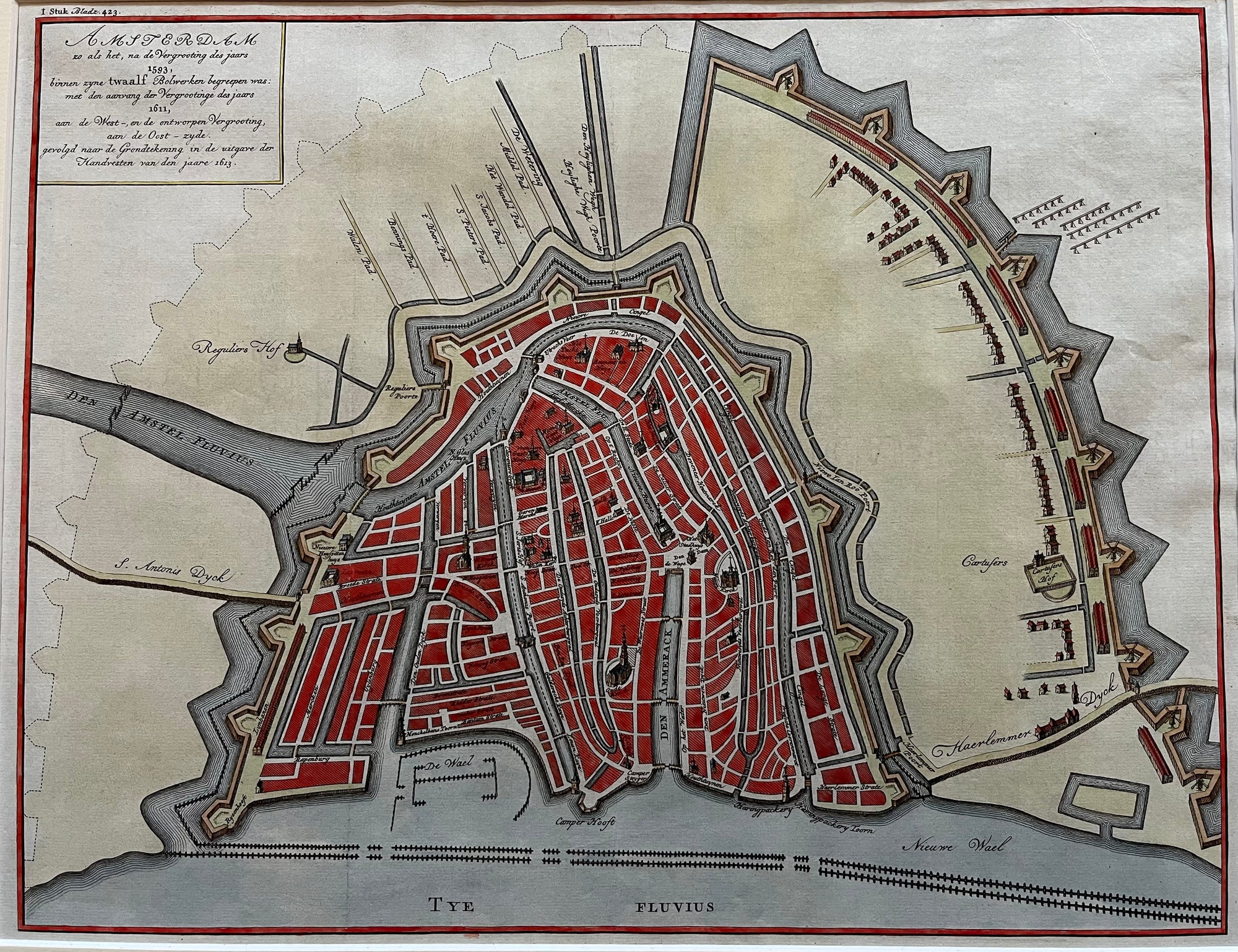
Map of Amsterdam
Sold Out
|
/
Quick Shop
Map of The Hague
€400.00
|
/
Quick Shop
Map of Alkmaar
€300.00
|
/
Quick Shop
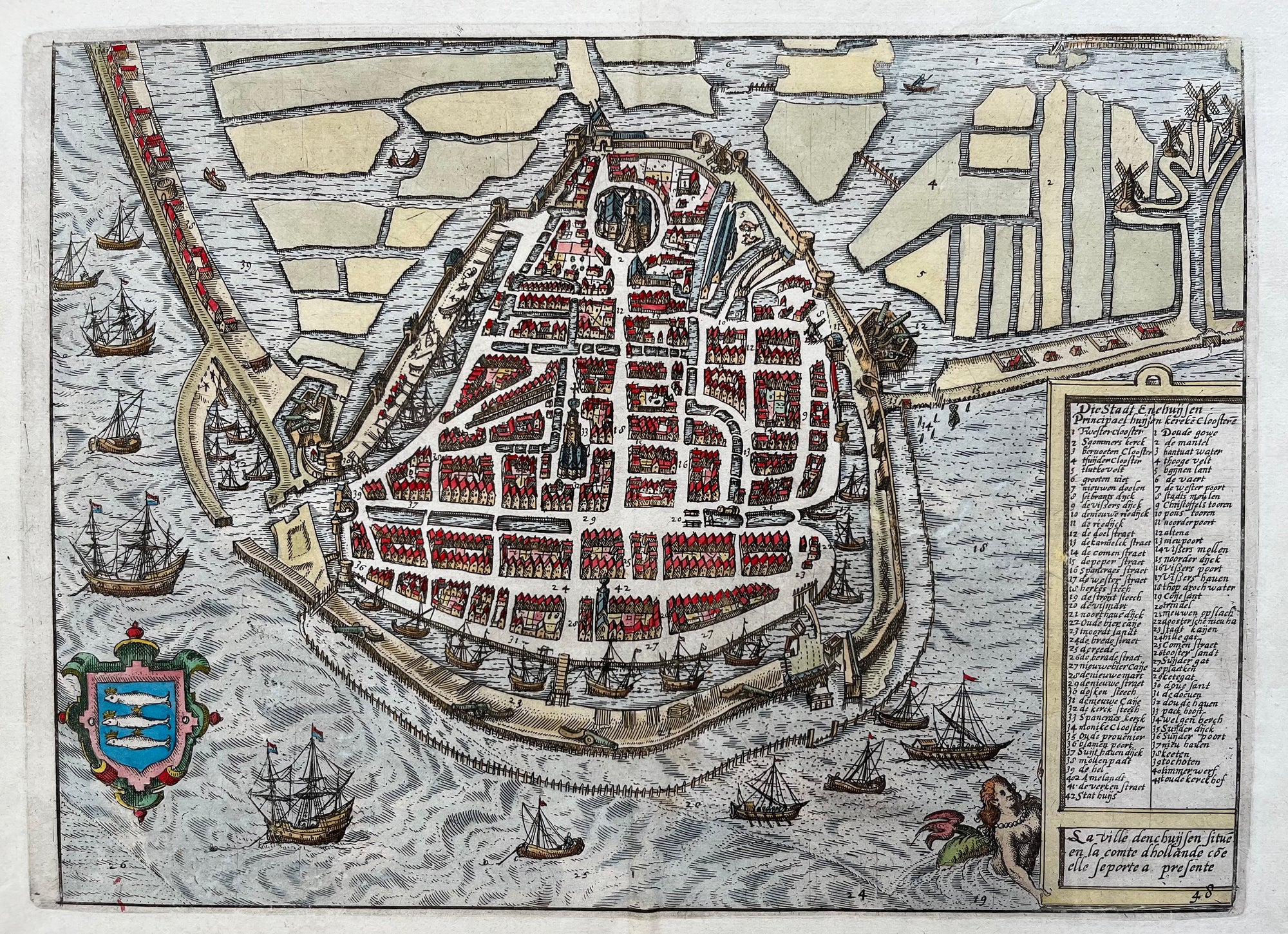
Enkhuizen
Sold Out
|
/
Quick Shop
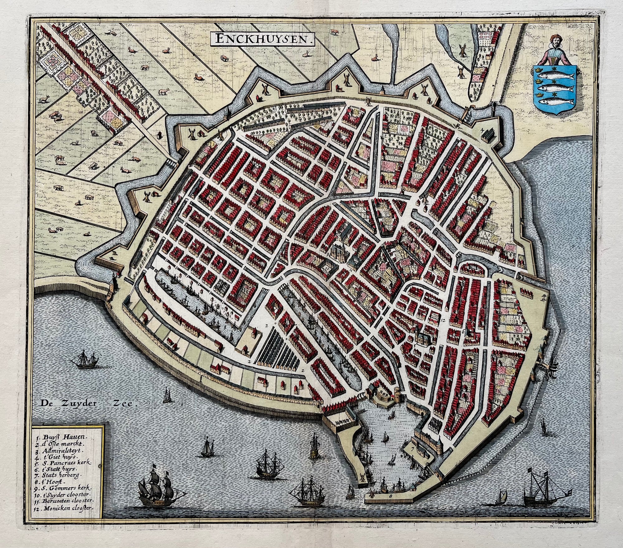
Map of Enkhuizen
€300.00
|
/
Quick Shop
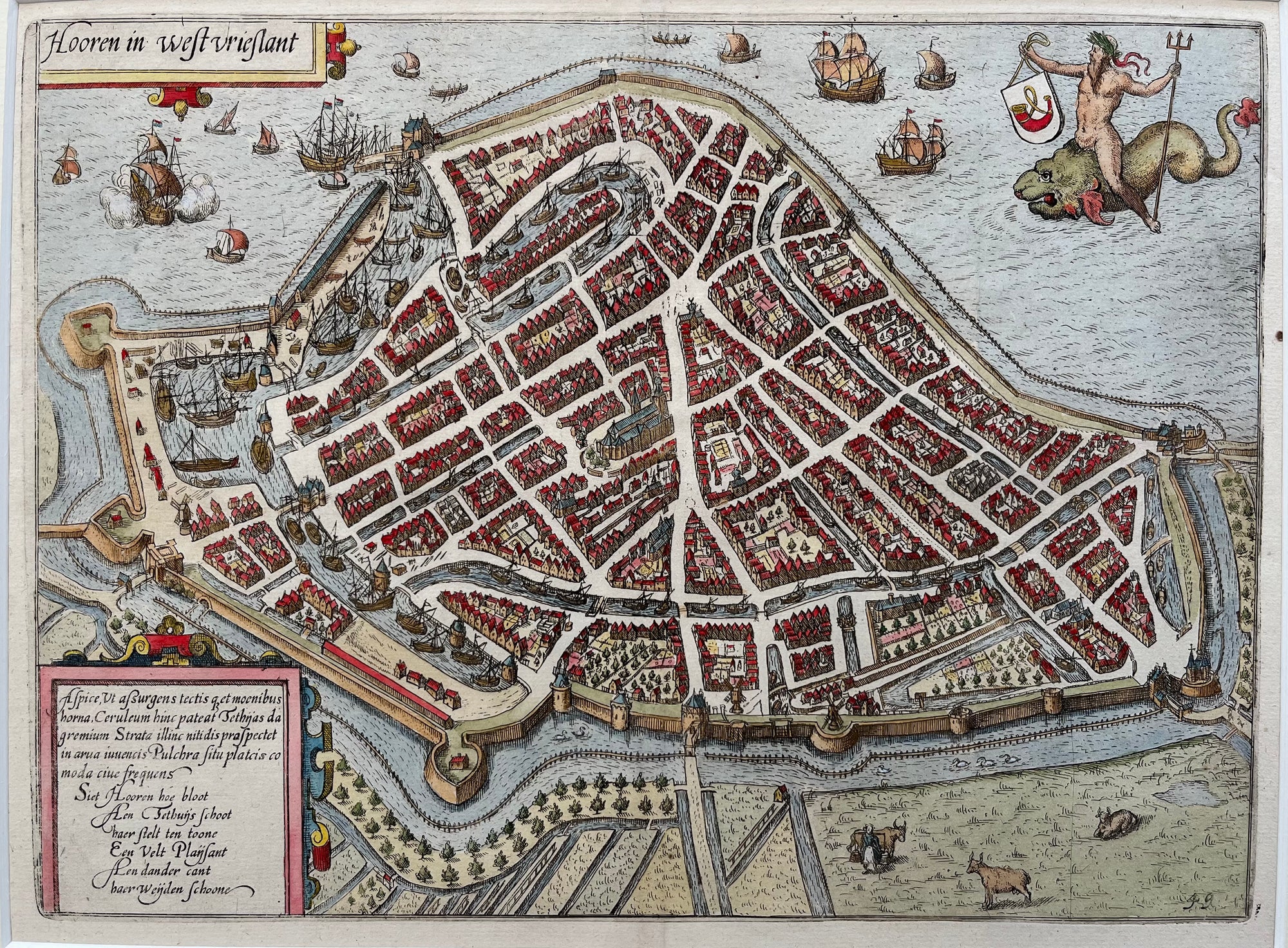
Map of Hoorn
Sold Out
|
/
Quick Shop
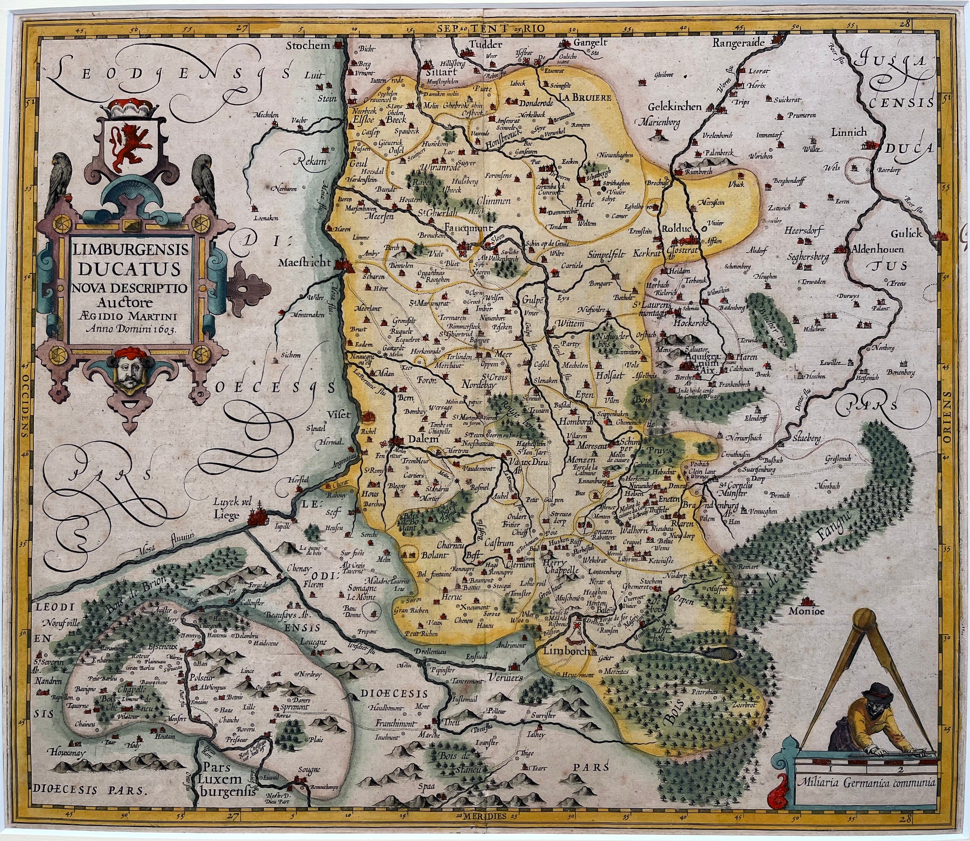
Map of Limburg
Sold Out
|
/
Previous
1
2
3
4
Next